Sunday, November 29, 2009

Better than cleaning chains and dodging pine cones

The storm that made riding unpleasant for much of the holiday weekend dumped abundant snow in the Whites. Hard to imagine, as it never got very cold in southern New Hampshire. Bretton Woods was open Saturday on 4km of trail and expected to open more for Sunday as they cleared storm damage. I needed a recovery day Saturday anyway, so timing would be perfect. The nearly foot of new snow would have a chance to set up.


Waxing skis is way less messy than cleaning dirty bikes.


I couldn't find any other takers on short notice, so I headed up solo. It was a brilliant sunny day. Heading up I-93, you could see that the Whites in the distance were indeed snow capped. Driving for nearly another hour, still no snow on the ground. There was zero snow in Lincoln and only a dusting at the summit of Loon Mtn Ski Area. As I began to head up into the Notch, it was like a switch flipped to winter wonderland. In two minutes it went from no snow to nearly a foot of snow. I feared it might be altitude only, but as I descended into Twin Mountain, the snow did not diminish at all. The snow bank at the corner of Rt 3 and Rt 302 was higher than my car. Awesome.

I got to Bretton Woods before 10am. The parking lot was full. Hope they had a lot more than 4km open, else things were going to be very crowded.


Thanksgiving weekend in the Whites

I waxed with yellow, figuring the wet snow was still saturated and it was supposed to rise above freezing. I think I got it right. Conditions were fast. The first grooming always contours the undulating terrain underneath, making V2'ing the first time on snow for the season tricky. Snow has much different feel to it than rollerskis on pavement. It took about 5-10km before I began to feel completely comfortable. I'd guess around 6-8km were groomed when I started, and the chainsaws were still going on some trails to clear the way for the groomer. Heavy, wet snow and subsequent wind took a lot of trees down.

There were numerous juniors there on classics, maybe out numbering skaters 3:1. Saw a couple familiar masters faces. Trails were busy but it rarely interfered with keeping a nice tempo pace going. I planned to ski about 2hrs/30km, but when I saw the groomer had made a new sweep through the biathlon range area, I kept going. How often can you skate right after the groomer on 10" of new snow and it is perfect? The moisture content, density and temperature were such that the freshly groomed snow set up instantly. Seems the wind carried the scent of fresh corduroy, as this new 2km of trail quickly filled with skaters. Big smiles all the way around, perfect V2 cruising material. After a couple bonus laps on this stuff, my turkey pop-out button popped. I was cooked.


All the flat stuff was groomed by the time I finished.

I skied about 37km in 2.4hrs. The only thing missing were hills. Due to limited terrain being open, BW was charging only $10. This includes showers and fresh towels! I think that was the best $10 I've spent all year. Sure beats another ride in glop and having to spend an hour cleaning the drivetrail again.  No chance of hitting BW mid week, so it looks like its back to dodging pine cones on rollerskis. Going to suck.

Friday, November 27, 2009

Better than shopping at Kohl's

Black Friday to some is Turkey Burner day to others. FOMBA puts this great ride on each year. I've been doing it as long as I can remember. Seen every kind of weather and conditions too. It was 25F with rock hard frozen ground one year, at least two years with 2" or more of snow on the ground, near short sleeve weather another time, and a few times with rain or wet conditions. This year was the wettest. Give me any other conditions.  Low 40's and pouring rain is the worst.


The line for Kohl's entry

A few of us hoped to hook up early for the ride. Getting up at 7am, it seemed doubtful anybody would be stupid enough to go mountain biking in what I was looking at outside. I didn't relish the thought, but the night before I emphatically stated I would go if anybody else did. SteveG didn't back down. The weak in spirit shall go nameless. That meant I had to kit up after all.

Getting there a half hour after registration opened, there were less than 10 cars in the parking lot. Last year there were over a hundred by the same time. It was pouring, and it was not warm. I signed the waiver, and Jack Chapman quipped they added a couple hills to the course just for me. He'd also like to make a CX convert out of me. Some day... We didn't bother putting our number plates on. They would've soon disintegrated anyway. Besides, it's just a fun ride.


The line for Turkey Burner registration

Steve and I were first to roll out. There were no other tracks in the mud. The 27 mile course begins by looping around Massabesic Lake on fire roads. There was no point in avoiding the puddles. It was all puddles. I wore AmFib tights with DeMoulas baggies under neoprene booties. Up top, a base layer, a medium weight PI thermal layer and a waterproof vinyl rain shell. A heavy weight beanie and lobstah mitts finished the kit. It worked well.

We finished the fire road section and got to Auburn Center. Funny, the arrows didn't go the normal way for the "hero" singletrack section. We surmised that maybe Jack wasn't joking, they routed the course over one of the ledges along the lake. Well, the short beginner loop does just that, a section we usually don't hit. Before we knew it, we were heading back towards the cars. Backtracking began. A bit of road took us back to Auburn. Either hooligans removed some arrows or things were marked more tersely, particularly the sign that normally splits hero from beginner loop.


Steve on Fireline. Pefect day for a MTB ride, eh?

Back on track, the 3+ mile Fireline trail was first, one of the more technical. FOMBA is characterized by super twisty singletrack with non-stop roots and rocks. It can be challenging to clean when dry. Do it in steady rain, it is definitely expert material. I think Steve and I were getting more chuckles per mile than we ever have, laughing at our own or each other's bobbles. Long Trail was next, 2+ miles, and the most technical. I dabbed three times, which is quite good considering conditions. Woodpecker is the newest trail. It is the most buff, but today was the deepest (water) and greasiest. We pretty much race-paced the thing. I could not shake Steve off my tail. I thought surely one of us would have a rendezvous with a tree before this silliness ended. We survived, barely.

On Lady Slipper, a few guys below on the rail trail spotted us and took a short cut up to Lady Slipper. They looked pretty serious, so I ramped it up a notch. One of them passed Steve and was gaining on me. Funny how something like that pushes you into race mode. This trail is lots scarier at speed than Woodpecker. More rocks to break bones. I managed to hold the guy off until coming back to fire road. We waited for our riding buds. Turns out that the group of three were lost and were puzzled by lack of singletrack. Hmm, Steve and I hit about 8 miles already. They also missed the turn in Auburn and went all the way back to the cars. They weren't familiar with the area and didn't know any better. Fortunately, we were near the kiosk with an area map, so I got them situated with the start of the "hero" section.


Steve had taken a header on Lady Slipper. Stuff like that happens when you are getting tired and fast guys show up on your wheel. He decided to call it a day with over 2hrs riding time so far. I was still doing ok, not getting cold, and figured I might as well finish it while I'm out there. There were still seven named trails to finish. The pace until now had been quite brisk at times. I backed it down for the remainder of the ride, a comfortable tempo pace just enough to keep warm. I did not see another rider for the next hour, and it didn't look like any of the trails had been touched yet (except for Fox Tail, which the group of three found by accident). There was a brief lull in the rain, but it soon came back with a vengeance.

When I got back to the cars, none of the cars that were there when Steve and I rolled out were left. Only a handful of other cars were there, and half of them might have been dog walkers. Most years about 300 riders show up.  Doubt even 50 made it today.  It was not the suckfest I anticipated. Not only was it better than shopping at Kohl's, it was downright fun. I finished with 32.3 miles on the odometer in 3.4hrs riding time. The ride normally goes about 27 miles without missing the Auburn turn. I wonder what next year's 'Burner will bring?

Thursday, November 26, 2009

Fat Doug Returns

Towards the end of summer, my sustained body weight was reaching a 30 year low, right around 160 lbs. I wasn't doing anything special. I traded intervals for "just riding my bike." I certainly didn't curtail eating. Research suggests interval training doesn't burn calories as effectively as steady moderate efforts. You do your hard 3-5 minute efforts, destroy your body in five of these, then you are done for the day. I've been doing a lot more mountain biking this summer and especially this fall. Without focused, intense efforts to break my body down, I can ride moderately hard for the whole ride and on most days. This undoubtedly burns more calories per week than doing a couple days with short uber hard efforts, often necessitating a rest day the next day.


Then work got busy. Hours went up. One- or two-day business trips with no chance to ride. Lunch meetings have become increasingly popular, as we are already working evenings, so the only time left to squeeze meetings in is at lunch (when I ride). This drives stress levels went up. Stress alone can cause one's body to make fat. Adding it up: reduced aerobic activity + increased stress + loaded meals in meetings or on travel = weight gain.

I didn't hold back feasting today. Out of curiosity, I stepped on the scale. Precariously close to 170! Not quite an apples to apples comparison though. I normally weigh myself in the morning when I'm partially dehydrated, not after eating half of a turkey and pumpkin pie. The body fat is inching up too. I'm normally around 9% in the morning (dehydrated) and 7% later in the day (fully hydrated). 10% late today is clearly a bad trend.

I'm don't freak over this shit. Do you? Some do but won't openly admit to it. I do not obsess over food or my weight. I've had no trouble maintaining a weight in the mid to low 160's for 10 years. The sooner snow gets here, the better though. XC skiing burns calories at a much higher rate than riding.

So what's with the Fat Doug bobble head? We all have good days and bad days on the bike. A while back, I was having a surprisingly good day when SteveG and I headed into the woods at lunch. He wasn't having as good of a day. Apparently I have a few annoying phrases, or euphemisms for wondering what is holding things up.  One of these phrases is "What's going on?" You know, wondering if maybe they had a mechanical, and that's why it took so long to come up that last hill. Maybe the brakes are rubbing or a tire is going soft. I guess when you are just sucking wind or have lead legs that day, you don't want to hear smart-assed rhetorical questions.

Back at work in email chatter, Steve commented to DaveP all he needed to finish making him go batty was a Doug bobble head that repeated "What's going on?", "Do you have a soft tire?", or "Is a brake rubbing?"  It just so happened that I had a Michelin Man bobble head in my office, something that was thrown in a race swag bag this summer. Yeah, that will work.  A quick print of a Fat Doug picture from the web and a permanent marker completed the Fat Doug bobble head. It was perfect Steve wasn't in his office when I placed it on top of his monitor. I could almost here him go GAH! from the other side of the building when he returned. Yeah, we can have fleeting instances of fun at work.

So now Fat Doug stares back at me by my home computer as a reminder.  The equation is a pretty delicate balance. When weekly volume normally burns the equivalent of two pounds of fat, a protracted period off the bike would produce a dramatic weight gain. Even a 25% reduction in volume could see a two pound gain per month. That's probably the realm I've been in the last couple months. As long as other factors don't interfere with riding and training, my weight takes care of itself. When training runs into interference, some manual intervention may be needed in the diet. Not looking forward to it.

Monday, November 23, 2009

Hill Junkie Basement

I placed separate orders recently for two kinds of tires - 26" studded tires and 4" rollerski tires (actually wheels minus bearings). They arrived the same time. I've gotten about five seasons on my Nokian Extreme's. The tread is still in pretty good shape, but the carbide studs are about half gone. This means they no longer offer superior performance on icy surface. Suitable for road riding, but risky on off-road ice flows. The new Nokian's, now called Extreme 294 (294 studs per tire), have a modified tread design. It is more open. I suspect they will roll slower on hard surfaces, but that is hardly a concern for winter riding. I'm mostly after the quality of riding outdoors, getting good training value, and avoiding the dreaded "point ride" on a trainer. Bikeman.com had a good price on these at $70 each. I spent about as much for two new tires as I did on my new Niflheim rollerskis with four wheels.


26" Nokian Extreme 294 with 4" Pursuit "slow" wheel

The 4" wheels are replacements for my Pursuit rollerskis. I've half used the wheels that were on them in two seasons. They don't handle the same when the wheel diameter gets smaller, they are more susceptible to skidding on stones and pine cones, and they seem to be getting faster with less rubber on the wheel hubs. They were too fast to begin with. So I'm replacing all four wheels with higher resistance tires. I will continue to use my Pursuit's on rainy days, especially after roads are salted, and for lunch break workouts. Salt is very nasty to bearings. I'll use my new Niflheim's for hilly endurance workouts.

When I scouted for a hook to hang my new Nokian tires on, I was confounded. All my tire hanging hooks were already overloaded. A quick count around the room revealed I have over 40 tires not mounted on bicycles right now. At least 10 of those are new, 20 of them barely used, and the remainder still in good shape. I don't keep junky tires around. How does one accumulate so many tires? I think a lot of the slightly used ones were experiments. They looked good on paper but performed poorly on the road or trail. Time to have a sale.


Pan of Hill Junkie basement. Much smaller than it looks. Hi-Rez

I also took note of my tube inventory. Over 50 in stock! Most of these are brand new in the boxes. I have several sizes of MTB tubes, from 1" for road slicks to 2.2". I even have a 29" tube and don't have a bike for it yet (I needed a spare when I rented a 29er last month). On the road side, I have 23mm tubes for racing and training, 28mm tubes for the tandem, 650c tubes for a bike my wife doesn't own anymore, and 35mm tubes for 'cross. Then mix in thin and thick wall, butyl and latex varieties into the mix. This adds up to enough tubes to last me 15 years. I don't throw away a tube from simple punctures either. I'll patch a tube up to two times before I discard it. I rarely flat.

I am completely out of space in my workshop. It is supposed to be a wood working shop, but bicycles and skis have completely taken over things. My Delta contractor's tablesaw doubles as additional workbench space when my primary workbench becomes clogged. Back in Michigan, I had a detached 1000 square foot building to keep this stuff in. That's when Fat Doug did multiple wood working projects per year and did not own any bikes.

Some day I'll design and build another house. It's hard to visualize that being more satisfying than riding and racing bikes right now. Cathy and I built our house in Michigan ourselves with very little outside help. We hired out only the site preparation, foundation, and thin-coat plaster work. We did everything else. It is a huge commitment, essentially a second full-time job for a year. No way I'm selling off the wood working equipment yet. I have two options to gain more space. I could move some of the equipment up three flights of stairs to the attic and hope I don't need to use it any time soon. Or I could put up another building on our property, pay lots more in taxes, just to have a place to keep infrequently used equipment. I sure hope I don't take a chunk of plaster out of the wall lugging a 150 lb jointer up the stairs.

Sunday, November 22, 2009

Niflheim S600 Review

I finally got a chance to properly put my new rollerskis through the ringer. They are the Niflheim S600's. They come stock with speed reducers. I own a set of V2 Aero's with speed reducers, but I got sick of buying tires and tubes for them. Plus you never know when a tire will disintegrate. You could be 8 miles from your car. The V2 speed reducers work great.  I like to do hills and I'm not skilled or brave enough to go 30mph down roads with no means of slowing down or stopping. You roadies out there, would you go 30mph down a hill with no brakes on a free wheeling bike? I bet not.  Too much shit can happen, like cars, dogs, debris or potholes.  I've been using my Pursuit rollerskis most of the last two years. These use 4" solid rubber wheels, but do not come with speed reducers. The Pursuit's limit how hilly of terrain I can tackle. The loop I do at work has a modest blip in it, staying under 20mph on the descent. So I was looking for a low cost, low maintenance rollerski that could be equipped with speed reducers. The Niflheim's perfectly fill this niche.


Niflheim 600's with Pursuit's in background

I ordered a set immediately after learning about them on Alex's blog. I transferred bindings over from an old set of skate skis that are beyond "rock ski" condition. Out of the box, the Niflheim's felt quite heavy, at least compared to my Pursuit's. Some of the weight is in the speed reducer mechanism, but I suspect most of it is in the alloy shaft. The extrusion has at least 50% thicker wall thickness than my Pursuit's. Perfert for 200 lb guys. The shafts are also about 2" longer than my Pursuit's, presumably to accommodate speed reducers with big footed skiers. Longer rollerskis should emulate skate skis better.  I also noticed that in higher resistance settings, a sharp jolt could dislodge the speed reducer back to zero resistance. This worried me some. Could a crack in the road do this, right when you needed the most resistance? The escapement latch has a very wimpy spring in it. A spring with twice the torsion would solve this concern. The shape of the latch teeth contribute too. They angle down. I found that the powder coat paint was very slippery. I scraped it out of the latch teeth. The latch was much less likely to slip then.


Nothing but walls with no brakes

Sunday morning I met up with Brett R at his house for a two hour roll. He warned me to make sure I bring good working speed reducers (like my big-wheeled Aero's). I brought my new Niflheim's instead. Brett's route is more or less an out and back in Westborough, MA. It was friggin hilly. None of the Littleton gentle rollers, these were full-on walls. I think Brett wanted to hurt me. The steepest climb had a sustained grade of 16% per my Garmin. The pavement was not good, chip seal over busted asphalt. At the top, Brett said we had to go back down that! This is from a guy who's more cautious on the descents than I.

We hit a chip seal descent that was really rough. With no speed reduction set, the latches rattle something fierce on the S600's. It was so loud it was hard to talk to Brett over it or hear approaching cars. The rattle wasn't the only annoyance. The stiff aluminum shafts sent all that vibration into the ankles. It was so intense that it tickled funny bones in my feet, making me recoil from the vibration. I think my Pursuit's would behave similarly on this particularly harsh section of chip seal, but without the rattles. The extra heavy duty shafts on the S600's don't exactly help dampen vibration.


Min and max speed reducer resistance settings

Now here's the deal with the S600 speed reducers. If you set them to just rubbing the tire in the off position, you get only about 50% of the braking power of Aero's when going to max resistance. If I accept more resistance in the off state by adjusting the resistance bearing tighter, I get a little better max state resistance. But then I'm killing myself on the flats. Basically, the range of speed reduction is quite small. You can get 0 to 1/2, 1/4 to 3/4, or 1/2 to full by wrenching the initial preload in the resistance bearings. Starting with little resistance means you'll never get a lot in the max state.  I can get 0 to full with my V2's with no wrenching. Now you may counter with say, "competent skiers don't need all the speed reduction," or "if you really need that much speed reduction, route choice needs improvement." These are valid criticisms. I found I pretty much was using all or nothing of the S600 speed reduction range. Even in minimum state, slower rubber wheels and the residual speed reduction resistance made the S600's much slower than my Pursuit's, which frankly were too fast anyway.


Two ways to improve speed reducer resistance range

There are two ways to address this resistance range deficiency. One is to move the resistance arm pivot point back slightly so resistance ramps up more aggressively. The other is to space the teeth further apart, using a slightly longer latch mechanism that lets the resistance arm swing further. I just may make my own latch. It is very simple, laser cut aluminum. I could probably make a pair with a band saw and belt sander.

On our return, Brett and I went around the 16% descent but hit an almost as steep descent one road over. Brett yelled something at me as I bolted away. It sounded like "it get's steep," but he really said "it stops at a tee." I had my resistance on maximum, was snowplowing like crazy to scrub more speed off, and was still going over 20mph. It got steeper. Then I saw the stop sign at the bottom with ZERO run-out. It was hard to tell if cars were coming or not, so I was looking for holes through trees and rocks to bail if it came down to that. No cars were coming. I merged onto the cross road at about 20mph. I waited for Brett, who had and used twice the resistance I had available. I could see panic on his face coming through that stop sign too, at half my speed. Then he's laughing when I told him how insane that was. Proof he was trying to kill me. I think he's trying to eliminate a potential threat at the races this winter.


Plummet of Death with stair step climb in distance

We had a long stair step climb coming up next. We had been out about 90 minutes, and I still felt pretty good. Kind of knowing the way back, I passed Brett and ratcheted the pace up a notch. I V2'd pretty much the whole way up the sucker and put a little distance on Brett. That was payback for the hairball descent. We got back to Brett's house in exactly 2hrs rolling time, covering 17.0 miles with 1600ft of climbing. Seems really slow, but you'd have to see the climbs and some of the pavement to have the whole picture.

In summary, here's what I like and don't like about the Niflheim S600's:
Likes
Seem ultra durable
All stainless steel hardware (salty roads no problem)
Anodized shafts
Speed reducer releases easily (V2's are awkward)

Low price includes speed reducers

Dislikes
Speed reducer range is very limited
Speed reducer rattles in lowest setting
Tad on the heavy side (still 200g/ski lighter than V2's)
Sturdy construction transmits more road vibration

I'll definitely be using these more. I'm sure the speed reduction range is just fine for the Littleton loop. The Littleton course feels safer to me anyway. There was only one gradual descent to stop sign, and the asphalt on average is much better in Littleton. I felt quite stable on the S600's. They really don't handle much differently than my Pursuit's.  I think the S600 speed reducer design is quite clever, certainly worthy of patenting (if patents didn't cost so much).

Saturday, November 21, 2009

Going Long at Leominster

I had a choice today between doing a local CX race or going on a "high IQ pleasure ride." Race reports tend to produce more interesting blog fodder. The deal is, I've been enjoying the off-road riding more than ever this year. I also haven't done any focused intensity work in about three months now. That will change as the ski season ramps up. I weighed fun-factor of a 45 minute race versus a four hour ride at a place I haven't been to in a while. A fabulous fall day was forecasted. The long ride option won out. This means no race report. Sorry.


DaveP was also interested in a long ride. We considered options in the White Mountains, seeing there is still zero snow even at the summit of Mt Washington. Many routes I've been kicking around are untested. I really prefer to test them alone first, as I don't mind so much if I end up in 30 minute hike-a-bike rock scrambling slog.  Dave has never been to Leominster State Forest, and I don't think I've been there yet this year. With Wachusett Mtn nearby to stretch the legs on before heading into the woods, there is more than enough riding material there to keep endurance junkies entertained for 3-4 hours.

We started out with a jaunt to the summit of Wachusett. No hammering, just nice hard tempo pace for me. Took 21 minutes via the old Wednesday night TT route (minus the hairpin extension). Not bad at comfortable pace on full suspension MTB with knobbies, considering my typical time for the TT was over 18 minutes. Many hikers were up there. It was too hazy to see Boston though.


Dave cresting Wachusett summit

We went down the gated back side, a mix of badly busted up asphalt and gravel. We may have gone a little "wayward" heading down, sampling just a taste of forbidden fruit. Swinging back by the car, we picked up Camelbaks and headed into Leominster State Forest for the main course.


Undisclosed location, but might have something to do with coming down what's in background

A few neurons must've died since the last time I rode in LSF. I forgot how my loop started out and promptly got all turned around in there. After about 15 minutes, it came back to me. None of the trails have published names, so there's not much to say about which trails we hit. Basically, we hit almost all of the singletrack I know about. About a third of the way into the ride, we climbed Ball Hill. It should really be named Ball Buster Hill. With leaf drop and Friday's rain, traction was scarce in many places. Dave and I both cleaned the 300ft beast. Off the back side, heading kind of northeast, is some of the most brutal and technical terrain in LSF. Dualies are highly recommended. I ran my tubeless tires silly low, maybe close to 20psi, to find traction in the leaves. Dave was on a Santa Cruz demo bike and did not have the luxury to go as low with his non-tubeless setup. He still cleaned almost everything anyway.

Last year I dabbed continuously in LSF. More than doubling my off-road riding hours this year has paid big dividends. I've gotten most of my finesse and some of my cajones back. I was having one of those rides where I was just "on." Legs felt good, and almost no fear-factor let me carry much more momentum than I usually carry in LSF.

Poking around in Google Earth and on the web looking for ways to extend a LSF ride, I found the Monoosnoc Ridge Trail above the town of Leominster. Photos from vantage points looked nice. Had no idea if it was rideable, singletrack, or even open to mountain bikes. The vague map also didn't make it obvious how to link it in from planned LSF route. We'd have to wing it.

Towards the far northeast corner of LSF, I started looking for trails/doubletracks that might take us up to the Monoosnoc ridgeline. I did spot a brand new piece of singletrack, one I think Steve G was telling me about recently. It went up. A lot. And over many large rocks. It was wet in places too. Most of the riding thus far had been surprisingly dry despite heavy rain Friday. I had major fun on this trail, as when you are "on," you want to milk it for all its worth and keep going on challenging terrain. I dabbed only twice before cresting the high point. There were more spur trails from this trail that will have to be explored some other time. Unfortunately, this trail did not cross the Monoosnoc Ridge Trail. We came out on Elm Street by the Haynes Reservoir. Now I knew where we were. Monoosnoc crosses Elm St close by. The trailhead did not prohibit bike use, but did not specifically allow it either. Prohibited uses to permitted uses were at least 4:1. A man was hauling ice storm logs out of the town land and seemed cool to our presence. He commented most of the Monoosnoc Ridge Trail was indeed doubletrack. We decided to hit a few mile section to the next paved road then cut back into LSF to wrap up the ride. This took us over Bayberry Hill, no view, then bony descent to Wachusett St. Have to explore in here more some other time. It is a very large tract of land. There were spurs trails off the main trail, and we missed the northern section with alleged views.

We followed a bit of pavement to Parmenter Rd, the fire road that bisects LSF. This leads directly back to the cars parked off Rt 31. Another snippet of singletrack, which is actually signed Loop Trail was hit on the way. Many other mountain bikers were just heading out as we were wrapping up our ride. It was warm enough to go in short sleeves most of the day. Awesome for late November. I wore hunter's orange to be safe. A single archer was encountered. The ride finished out with 36.3mi, 4280ft in 3:50hrs on the Garmin. Definitely my longest ride in LSF, and nearly four hours there produces more punishment than twice as much at Kingdom Trails would. Just non-stopped brutal, and this time I totally loved it.

Tuesday, November 17, 2009

Lollipops and Spaghetti

How many of you think about the topology of your routes, be they running, skiing, biking? Are you content with out-and-backs? Laps around a circuit? Or do you like to cover some distance and the only place you see twice is where you started? I've always preferred single big loop routes, whether it be training, racing or just heading out for pure enjoyment. After reading Racin' Rick's post about the dreaded out-and-back, I thought a bit about this from an analytical perspective.

My favorite races this year were single, monster loop affairs that cover serious terrain. Some of these were the Battenkill road race, Ironcross CX and the Vermont 50. These races boast about their single loop epicness. You don't do laps around a circuit, you don't see anything twice.

I strive for the same in most of my riding and skiing. My favorite loop on the planet is the Monarch Crest Trail in Colorado. A 54 mile loop that encompasses many thousands of acres. At Waterville Valley, I love doing a perimiter loop on skis. This just so happens to hit all the high points on the trail system, and it encloses a lot of terrain in the middle.

Engineers love figures of merit, often abbreviated FOM. A great FOM that applies here is the Isoperimetric Quotient, or IQ. Not making this up. Follow the link.  Basically, in Euclidean geometry, a perfect circle encloses the most area for the least perimeter. In terms of riding, a circularly shaped route will enclose the most land for a given distance travelled. Thus if you want to continually see as new of stuff as possible the whole time you are riding, pick routes that have a circular shape to them. The IQ is normalized to the circle, so IQ = 1, or 100% for a circle. So let's look at other, non-circular ride formats.

The Out-n-back.  I generally dread these like Rick. Sometimes they are unavoidable, like hillclimbs. In these special cases, I'll suffer through a return descent, as the reward is the summit. Trail out and backs suck, road out and backs suck even more. A lot of tri-guys do out and backs on their tricked out bikes. I don't understand this.  The IQ is zero for these rides, as no area is encompassed by the route.

The Lollipop Loop.  I will do lollipop shaped rides once in a while, especially if the lollipop stick is short relative to the yummy part. If we assume the stick is equal to the diameter of the yummy part, we get an IQ of 58%. This is an infinite improvement over the out and back, but only a little better than half that of perfect circle. This means you are only encompassing about half the area you could for the distance you are riding, and almost half the ride is seen twice.

Triangle. The triangle is another possible ride shape. Some of my work lunch rides might be triangularly shaped, where I head out a ways, cut over an equal ways, then come back an equal ways. Not a bad deal in IQ terms, were a 70% efficiency of a circle is achieved.

Square. I can think of a couple rides I like that have square shape to them. Often, these are where I go up and over a mountain range, traverse over in the valley, then come back up and over the same mountain range at a different gap, finishing with a traverse back to my car. Riders that do two gaps of Vermont 6-gaps could encounter a square shaped topology to their ride. A ride I did in Silverton, CO this summer had a square-ish shape to it too. Getting much closer to a circle's efficiency here, with IQ = 78%.


No ride will be a perfect square or circle. But you get the idea. Simple shapes encompass the most area and have the potential to present the most scenery. These rides give you a greater sense of accomplishment. You could go to the Londonderry Track and ride 300m laps all day. It is nearly circular. But you'd have to divide the IQ of 100% by N, where N is number of laps. In an hour, your IQ would be down to about 1%. This spells retahded. Similarly for circuit road races. You might have a 10 mile circuit, do it five times for a 50 mile race, but end of with an IQ of 20% or less.

Some of you techie trail riders may say wait a minute HJ, you're missing the point. Some of the best rides out there wiggle and squiggle all over the place and never go any where! Non-squiggly routes follow boring fire roads anyway and don't seek out interesting features.  This brings us to one more route topology.

The Spaghetti Loop. The FOMBA trails near Manchester, NH are a prime example. FOMBA had some unique constraints to work within, namely having very limited acreage to build unlimited trails in. The IQ for some of these trail segments might actually be negative, as you come close to the same point many times. The distance travelled is large, but you never leave your back yard, so to speak. Trails like these, if purpose built for mountain biking, can be quite satisfying. There are many other examples in New England, like the recently built Russell Mill trails in Chelmsford, MA. When land space is limited, make the most of it. Perhaps the Isoperimetric Quotient shouldn't be applied here, and something more like a Fun-Factor makes more sense.  I probably wouldn't want to ride on dense trails like these every day, but once in a while can be quite a blast.


I've left out a class of routes that cross over themselves or momentarily touch in the middle. Sometimes this is unavoidable in some areas when putting a long ride together. Nothing wrong with that. You can still encircle lots of terrain in multiple lobes. In your training, make your miles count. If you want to go 20 miles, find a loop that makes many small angle turns, approximating something like a circle. Pick a route that puts the largest number of acres in the middle. You'll feel like you did more, went somewhere, accomplished something. Doing the same training rides throughout the year can get boring enough. Seeing the same thing twice in a single workout doubles the boredom factor.

Sunday, November 15, 2009

Destroyed

Thus far this fall, I've been averaging about an hour per week on the rollerskis. I've been using my Pursuit skis with medium speed rubber wheels in back and faster polyurethane wheels in front on mostly flat terrain. Since Saturday and Sunday looked like a bust for any kind of riding, Brett Rutledge called and said CSU rescheduled their Littleton, MA rollerski session to Sunday and it would be skate technique. Hmmm, was I really ready to train with some of the top masters on an unseen route in drizzle?


Brett had sent me a cue sheet for the route. It supposedly went 14 miles with 900ft of climbing. I figured rollerskiing would suck the least given the deluge we just received. I was in.

A year ago I put all new tires and tubes on my Jenex V2 125mm Aero rollerskis. I've grown to hate them. Tires don't last a season, and unless you carry spare with pump, you could end up walking. More than a year went by, and I still hadn't used the new tires, which cost a small fortune. I exchanged the PU front wheels for slower rubber on my Pursuit rollerskis to slow them down a bit. My V2 Aero's have speed reducers on them, the Pursuits do not. I can go down short 4-5% grade hills by my house on the Pursuit's at terminal velocity just over 20mph. I know the run-out, it does not scare me. I threw both sets of rollerskis in the car heading for Littleton. I left early, planning to pre-drive the course Brett sent me to see if I could get away with my Pursuit rollerskis without the speed reducers. The route seemed ok to me. I was going to give it a go.

Fifteen skiers pulled in. Only a couple did not have speed reducers. Seems there was a positive correlation between age and probability of speed reducers. Guess young bones bend, don't break.  I asked around. I got scared. Guys much better than me use their speed reducers.  I capitulated and went with the clunky V2's. Besides failing tires, the V2's are much heavier and less stabile. Their only redeeming quality is the pneumatic tires are smoooooth on rough pavement.

We push off, soon into a 400ft climb. I started at the very back.  I did not know any of the kids and knew only a handful of masters.  The plan was to no-pole this climb. Andy with about half the group bolted. Initially I stayed back with Rob, Jamie, Brett and others. About half way up, my glutes were screaming. I relented in a couple spots and use poles.  After a while, my legs were chomping at the bit. I did nothing on Saturday and was looking to get a good cardio workout in. I slowly pulled away from my half of the pack and was in no man's land for a while.

The lead group paused for a bit near the top, as I caught them, with nobody else in sight behind me.  I took off with them but quickly realized they descend way faster than I cared to, being my first time on this route in wet conditions. Then the unplanned happened. They went straight where my cue sheet and pre-drive said we should've gone left. Hmm, where are they going? To hit more hills of course! Some seriously steep descents too. Had I used my Pursuit's with no speed reducers, I would have been royally screwed. Even with two of three notches set, I was hitting speeds over 20mph. For you non-skiers out there, keep in mind speed reducers are not brakes. You have to bend down and pull a lever on each ski to set friction on the wheels. If a car backs out of a driveway when you are going over 20mph, you are S.O.L. Terminal velocity on my Pursuit's would easily have been over 30mph. So much for the pre-drive to familiarize myself with the course. I had no idea where we were going or how long the route was going to be now.

I lost some ground on another long downhill where I over cautiously set resistance. The lead group put some distance on me, and to my surprise, I caught up to much of the rest of the pack I left behind. They did not take the Harvard extension the lead group did. I decided to wait with them to see if Brett would come soon. He didn't, as I learned later he took the long route too. I starting to feel some deep hurtin' by now and there was no way I would have been able to hang with the fast group for another hour anyway.

We reached another decision point in the workout where a neighborhood extension could be added. A few skiers were interested, but once the juniors regrouped with Rob and Jamie, they took the most direct route back. Another young skier, Jimmy, wanted to go as long as possible and was cool with me tagging along. Looking at the GPS track, this added about 5km to the loop. It was all good stuff, nice pavement, no cars, modest hills, and comfortable pace.


Garmin Edge 705 GPS Data, 1620ft of Climbing

We still had one more climb to do, Hill Rd. This darn near killed me, being about 2hrs into the workout. Hill Rd pops out on Taylor St, which kind of sucked. Traffic, busted up pavement, debris on shoulder. Glad again I had my V2's with five inch wheels.

I got back to the cars with Jimmy, tallying 36.2km, nearly 500m of climbing, in 2:15hrs skiing time. My glutes and hip flexors were destroyed. That was easily three times what I do on one of my weekly lunch hour hammer sessions, and 60% longer than I thought we were going today. Need to get a few more of these in before the snow flies. There was one minor casualty for the day. Brett took a header and has a nice fist sized raspberry on his hip. I loaded my GPS track to mapmyride.com. Note they totally butcher the profile. Barometric altimeter gave 1620ft, Topo 7.0 gives over 1900ft, yet mapmyride gives only 745ft.

I sent my membership app in to CSU a couple weeks ago. Joined NENSA too. Haven't heard anything back on either yet. I also ordered some new rollerskis. About a week ago, Alex Jospe reviewed rollerskis from Ed's newly launched Niflheim Nordic venture. Low cost, 4" solid wheels, with a good speed reducer design. I immediately placed an order.

Friday, November 13, 2009

Lake Solitude


With remnants of tropical storm Ida moving in this weekend, I wanted to take advantage of the driest trail conditions of the year. Friday was a non-working Friday for me. I wanted to hit something different, maybe something I never rode before. There aren't any popular riding areas within 90 minutes of my house I haven't hit. That leaves only things off the beaten path. So how do you go about finding something stimulating to ride that you've never ridden before, something that gets away from cars and people? You begin by zooming out in Google Maps imagery view and start scanning areas of higher elevation. You can tell where these are. They have different color shades, plus you can go to terrain view to be sure. I've ridden much of the Midstate and Wapack Trails along the Wapack Range, including notable peaks along the way. A little further north, Mt Sunapee caught my attention. I learned to alpine ski there with my son many years ago. What I never realized is that there is a service road to the summit. Bingo. I have biked to most New England ski area summits over the years, but somehow this one escaped my attention. As a bonus, there were many singletrack trail options from the summit.


Mt Sunapee service road, 30% grade section near summit.

I planned to ride up the service road, maybe check out a spur trail to Lake Solitude, then see if it was feasible to ride the Monadnock-Sunapee Greenway trail along mountain tops to Pillsbury State Park. I've ridden a major portion of the Greenway from Pillsbury maybe 10 years ago. Barely remember it. I do know that as the trail progressed northward, it became more hike-a-bike. Perhaps from the north, it wasn't as bad heading south.

It was a typical chilly November morning with a little sun poking through haze. I parked in the middle ski base area parking lot where some racers park for the Lake Sunapee Road Race. I loaded a GPS track I traced out on bikeroutetoaster into my Garmin. The deal was, I literally went right into 12% grade with zero warmup. This with legs trashed by a hammerski session the day before. The first 500ft was gained on semi paved road. Many sections were washed out or busted up.


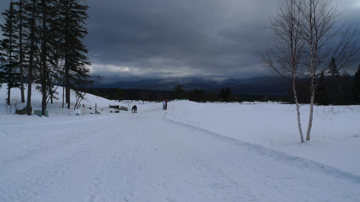
Lake Sunapee from near summit of Mt Sunapee.
Snow guns are all set for snow making.

About half way up the paved section, a fairly large animal runs out of the woods in front of me, stops a moment and stares at me. I thought whoa, what the heck is that!? It was the size of a coyote minus the bushy tail. It in fact was a bobcat. Although they are making a comeback in New Hampshire, sightings are still extremely rare. This was the first time I've seen a wild cat. They are much bigger than I expected. The one I saw stood two feet tall.


Bobcat from NHPTV website.

At the bottom of the Snowbowl Quad, the road becomes a narrow gravel affair and gets much, much steeper. There were many sustained sections over 20% grade. Fortunately the gravel was in pretty good shape. As I neared the summit, the grade kicked up at an angle that hurt my neck to look at. At first I thought it wasn't doable. This was granny gear, chest to bar, tip of saddle inserted you-know-where climbing mode. The gravel up here was frozen solid. There was no snow. I did make it, with the Garmin showing max grade over 30%. In just over a mile, the dirt road gained 1000ft. The summit of Mt Sunapee is at 2700ft, gaining over 1500ft from the parking lot. The view of Lake Sunapee was quite spectacular.


Solitude Trail. This was the easiest part.

After a few pics, I dropped down the road just a bit to where I saw the Solitude Trail head into the woods. At first I thought sweet, contouring singletrack! The trail quickly degenerated into rock scrambling for a bit. With that out of the way, the trail was intermittently rideable, maybe requiring a dozen dismounts in the next kilometer or so. It was much more rideable in the downward direction heading back. As the overlook to Lake Solitude neared, increasing patches of slickrock were ridden until the trail became all bare granite.

The view from the ledge of Lake Solitude was splendid. Who would've thunk there was a lake perched up on a ledge near the summit of Mt Sunapee? The dirt road/singletrack climb up here was well worth the drive. Bobcat sighting, and the climb was just long and hard enough to get the endorphins flowing. Throw great scenery into the mix, the buzz I had going was better than any of the stuff I did when I was a kid.


Near end of Solitude Trail on slickrock.

The route to Pillsbury State Park via the Greenway seemed like it would be more hike-a-bike than ride-a-bike. I decided to end this ride on a positive note and bomb back down the service road. I didn't realize just how steep it was. It scared me silly going down. I could not hit the water bars with any kind of speed. It was almost cold enough to freeze snot too. Cutting this ride two hours short meant I had two hours to ride some place else. I figured I hadn't been to FOMBA in a while, so I'll stop there just off the highway at Massabesic Lake.

It occurred to me that the Turkey Burner is just two weeks away, so I didn't want to ride anything I'll hit then. So what else is there, you ask? Lots. For starters, there's the old Watershed Wahoo course, which was positively the most roadie friendly course that every existed. All doubletrack, albeit some of it bony. And climbs, over 500ft per 6mi lap. Man I miss that race. Then there is a 1-2 mile singletrack climb across Tower Hill Rd that nobody knows about. I could work that in as an extension to a Wahoo lap. Finally, there's that "off the radar" trail near the FOMBA cluster. I see increasing forum discussion on this trail, but as of yet, nobody has disclosed the location. You would never find it just riding around. I see different names for it, like Hanger Banger, Evil FOMBA, or Hot and Cold. With the longest dry spell this year, I suspected the trail would be in mint condition.


Lake Solitude. Indeed it was. I had whole mountain to myself.

I parked at Massabesic Lake and set out on my plan. The only thing I would hit that the Turkey Burner hits would be the rail trail the Burner ends on. On the way to the Wahoo course, there's also another great piece of trail connecting the bottom of Tower Hill Rd with the rail trail. Probably legit, but nameless. After a Wahoo lap, I hit Evil FOMBA. Man, was it in nice riding shape, the nicest ever. Much of the area had been logged a few years ago, so most of the trail tread was devoid of oak leaves. That meant I could carry normal speed through all the tight twistiness. So why would somebody call it Evil FOMBA? Well, it is close to FOMBA, and it is like FOMBA on steroids. All the things FOMBA can't build are found here. There are no less than three huge teeter totters, over a dozen log rolls, some 4ft high, one A-frame over 5ft high, numerous hewn log bridges over water crossings, rock stunts galore including big drops. Everything is solidly built. The newest teeter near the middle is scary. I bet you are about 5ft up before it begins to teeter. I have yet to ride the A-frame. Wicked steep, too steep to walk over without slipping. I have ridden the other teeters on prior rides. The trail runs just over four miles and never has a dull moment.


The tallest teeter on Evil FOMBA.

I was going to post my GPS track for this ride, showing 24 miles of great riding that is not part of the Turkey Burner ride. But Evil FOMBA should still be kept under wraps me thinks. Hey, if you're doing the Turkey Burner and are interested in hitting the four mile wonder, let me know.

I finished the day with 32 miles, 3450 feet climbing, in about 3.5 hours moving time. I proved to myself I can still find hidden riding treasures close to home. I'll probably bike up Sunapee again some day, maybe see if I can work it into a bigger off-road ride out that way.

Sunday, November 8, 2009

Kelly Stand/Mt Tabor Loop

Great weekend for riding, eh? Unless you are a CX racer. Then you must've missed your double shot of brownie mix that has characterized most of the Verge series this year. Figures now that we have perfect conditions across New England, Dave Penney and I had to go out of our way to find less then perfect conditions. On 'cross bikes no less.

A loop that has been on my ride radar for a couple years now is the Kelly Stand Rd/Mt Tabor Rd double hump loop. Both roads reach high elevations adjacent to wilderness land in the southern Green Mountains of Vermont. Jim Hayssen, who joined us for 6-gaps a couple years ago, told me about these exquisite dirt gap climbs. I've ridden Kelly Stand a couple times, once last November, then again this summer on the tandem with my wife. Kelly Stand reaches about 2800ft elevation and is toward the front range of the Green Mountains. This means it accumulates snow earlier in the season than other areas, even the taller White Mountains much further north in New Hampshire.


Mt Tabor Road at Devils Den

We parked in Londonderry, VT. This was right at the base of the Mt Tabor climb. We planned to ride the loop counter-clockwise. It was barely above 30F when we rolled out in AmFib tights and lobstah mitts. Daylight is short these days, and we were starting a 5-6hr ride at 10:30am. Risky.  Steep climbing immediately began on paved Landgrove Rd. The coldness did not matter.  We soon ran out of pavement and found ourselves on 1.5 lanes wide dirt Mt Tabor Rd. Only a couple cars passed us the whole time on this 10+ miles stretch of dirt. As we reached the summit, there was a nice dusting of snow in the trees and on the ground. This implied there would be much more snow on the higher Kelly Stand pass.


The Vermont Valley with Green Mountains in background

The descent was marvelous, dropping about 1500ft in four miles. There were some nice views through the trees of the valley below from the winding bench-cut road. This dropped us on Rt 7, a paved road with wide shoulders. We promptly got off this on Mad Tom Rd, which climbs at a heinous pitch for a mile or more until levelling off after gaining 700ft. This too turns to dirt for several miles before dropping back down much closer to Manchester, VT.

We stopped briefly to refuel in Manchester before heading further south to pick up Kelly Stand Rd. Kelly Stand is one of my favorite dirt gap climbs. It is never steep as it follows a rushing stream for 10 miles up a narrow canyon. It also gains 2200ft from the valley. We hit the lowest elevation of our loop between Manchester and base of Kelly Stand Rd. The temperature had risen into the 40's here.


Kelly Stand Rd nearing high point

Climbing Kelly Stand gives you several false hopes of achieving the summit. You're climbing for 6 or 7 miles, see blue sky through the trees and think, ah, finally there. Nope. You round the bend and see another half mile of 5-7% grade. You go through this a few times before you really hit the high point of the climb. The deal today was we started seeing snow about halfway up, the same elevation as the top of Mt Tabor Rd. Last year when I rode this in November, there was no snow at the bottom, but 6" of snow and unrideable ice at the top. I worried a little bit. I knew it had snowed here earlier in the week, but I figured the sun had burned it off by now.

By the time we reached the summit, the temperature was below freezing and the road was ice covered. There was 2-3" of snow on the ground. The road was just barely rideable and made for white knuckle descending. A little ways down the ice and snow turned to slush and made a mess of bike and body. We could have ridden anywhere else and stayed clean, dry and warmer, but no, I had to drag Dave out into the boonies to find freezing cold slop.


FS-431, with Stratton Mtn in background, threw a bit of everything at us. Steep uphill grunts, bony descents, brush and blow-downs, snow and slush, sand and deep leaves. Not your typical drop-bar riding.

The prior times I rode Kelly Stand, I bombed all the way down on pavement, cutting across the Statton ski base area and down to Rt 30. I had a special treat in store for us today. Pavement is for pansies. We were going to cut across on Forest Service Route 431. This skirted high up on the flanks of Stratton Mtn, maybe half way up the ski area in altitude. I had no on the ground intelligence on this route. It can be seen in satellite imagery. We were on 'cross bikes afterall. Many people ride Kelly Stand and Mt Tabor on road bikes, but we came equipped for any uncertainties and some adventure. I had trouble finding FS-431. I thought it started before we picked up pavement on the descent. We backtracked. found a forest service map at the Appalachian Trail kiosk and got reoriented. Should have trusted the GPS. That cost us maybe half an hour. Our daylight margin was now down to about zero, and we had 25 miles to go, half of it off-road with unknown conditions.


One of several drops along the high terrain section of FS-431

We found FS-431. It was little more than a doubletrack rutted "cow" path. And still being above 2500ft, there was plenty of snow and ice around too. We'd have to average about 10mph on this 10 mile connector to get back to car before sunset. I recalled from the profile that there was "fuzz" along this part of the route. Normally, these sharp spikes aren't real in Topo 7.0. But dang if they weren't real this time. We must have went up and down about five times, rising and falling more than 100ft each time on bony doubletrack. Much of the descending was washed out rock garden, something heinous to tackle on a 'cross bike with 80psi tires. Then throw liberal coating of leaves and snow over the rocks for good measure.  Flatting out here with no daylight margin was not an option. Neither was poking along. I think we averaged about 7mph for the next 10 miles. We lost all the vertical in just the last couple miles. It alternated between rock garden, loose sand, snow, deep leaves, and many, many large water bars. You could never tell how deep some of the water bars were, as they were filled with leaves or mud. Dave whooped it up once we hit a real gravel road at the bottom. FS-431 was supposed to be the highlight of the ride. Don't think Dave saw it that way. It was barely CX bikeable. You'd even have to be careful on a full suspension MTB to avoid pinch flatting.

Once we hit pavement below Stratton, it was 10 miles back to the car. The temperature was plummetting fast, probably back down around the freezing mark. There were two modest 200ft climbs along the way. Dave lit it up on the steep 12% bitch. I nearly died trying to stay with him. He said it was payback for FS-431. The sun set before we got back to our car and cars had their headlights on. That is how close we cut it. The thought of having to spoon with Penney in the wilderness to survive the night was a strong motivator to not mess up. The GPS could have died. It was the only thing keeping us off the many spur two-tracks. FS-431 is gated, so it was cluttered with plenty of tree debris. A sheered derailleur would have meant trying to find our way out of the woods in darkness too.

I find the most satisfying rides are ones that you barely finish, either by physical limits or length of day. I've had closer calls with night fall, especially one time riding solo in California. Our ride went 76.7 miles with a 5.3hr riding time, climbing 6740ft. About half of the route was on dirt, and way more than half the time was spent on dirt. This is the longest dirt ride I've done with my CX bike, and a punishing ride it was.  Dave and I both agreed the Mt Tabor climb and descent totally rocked. We'll definitely be back to do this loop again, although I may have to rethink the FS-431 part.  I have some even more grand loops in mind for next year.

Tuesday, November 3, 2009

Dual State Double Header

Sheltowee Trace Trail, Kentucky


One of the objectives of my short riding trip was to hit two states I haven't mountain biked in yet. I saved Kentucky for the last day of my four day trip. Monday was forecasted to be a picture perfect autumn day. I drove up to Laurel River Lake, the backstop of the Laurel River Dam. I parked at the dam with intentions of hitting two parts of the Sheltowee Trace trail, a 200+ mile long trail that starts in Tennessee and runs the length of the Daniel Boone National Forest in Kentucky. The first section contoured the lake. The second section followed the Cumberland River. I figured both parts would be easy riding and I could tick off 40-50 miles in no time flat.

It was the coldest morning of the trip, about 39F starting out, so I finally had to break out the arm and knee warmers. They soon came off, however. There was nary a breeze nor cloud to be found. Temps soon hit 60F. Four miles of road took me to the entry point of the lake section of Sheltowee Trace. Some minor elevation change here and there, but the trail was mostly totally hammerable, wide benchcut singletrack. Heavy leaf cover had me nervous, but I rarely encountered any surprises. The trail was very well designed and drained, but there were a few nuisance blow-downs in one section. It seems long dead pines hit by beetles are still dropping. Laurel Lake is very clean. You can see bottom a long ways out from shore. I finished the 8 mile segment of singletrack in no time, swung past the car to drop shed layers, then ventured out on the longer, part two of the ride.

The drop into the Laurel River gorge was harrowing. The trail became hard to follow along rock cliffs and became extreme hike-a-bike. I eventually abandoned the bike to find the trail, to no avail. It was full-on hands and feet bouldering. Eventually I back-tracked and found a Sheltowee Trace trail marker. The trail continued deeper into the Whitman Branch gully. At the bottom, it was nothing but moss covered truck sized rocks. I learned chamois in your shorts work well not only for saddle rash, but they prevent butt burn when sliding down a rock slab with your 30 pound mountain bike too. I managed to bloody both legs up bush whacking through this section. When I finally crossed the actual stream, things didn't get any better. A huge blow-down made it darn near impossible to get through with my bike. It was shear cliff to high side and impossible steep bolders to the other. A fall down in here was not an option. Nobody would ever find me. I spent a good 45 minutes to cover one mile of distance. This was definitely not a mountain biking route.

I finally reached the Cumberland River at the boat launch. I figured I was good to go now, as the Sheltowee Trace trail was supposed to contour the river all the way to Cumberland Falls. Nope. A bit more hike-a-bike kicked things off. Then I drop down into another gully, not as steep as the Whitman Branch. At least it had a newly built bridge over the actual stream crossing. But it also had a sign warning of bridge out three miles ahead and crossing was extremely difficult. What the heck did I just do? If that was not difficult, what would extremely difficult entail? After Sunday's debacle, I became half a brain cell smarter and decided to cut my losses here and now. I climbed back out of the gorge via the paved boat launch access road and headed back to the car. I figured I had just enough time to ride at Big South Fork, not far out of my way back to Knoxville. For the morning, I logged 22 miles in 2.25hrs with 1850ft of climing. That would be the extent of my Kentucky riding this trip.

Big South Fork National River and Recreation Area, Tennessee

Yeah, that is a long name, and the only National River and Recreation Area declared by congress. This is another area of Tennessee where rivers have cut deep into the plateaus over eons to create great chasms in the Earth. This makes for great riding and viewing opportunities. I still hadn't reached great vistas by bike on this trip, and I hoped to score some good views by coming here.

I got to the rec area around 1:30pm, kind of late to begin a ride in remote country after the clocks went back an hour. Interestingly, the central/eastern time zone boudary runs right through the middle of this park. There was nobody here. Looks like they pretty much boarded things up for the season. Fine by me. I wasted no time in hitting the dirt.

There is a loop referenced in the trails guide book I picked up I wanted to try. It is open to bikers only on weekdays. Hikers have sole access to it on weekends. The loop links the Grand Gap Trail with a section of the John Muir Trail, an 18 mile singletrack loop along cliff ledges. A few miles to and from the loop on dirt road brought total mileage to about 25 miles.

The trails were eminently rideable and meticulously maintained. I stopped for pictures frequently on the Grand Gap segment. Many of the ledges were Moab-class with free-fall drops of hundreds of feet. The trail never came freaky close, but I suspect if you bobbled in a ridiculously bad way in a couple places, it would be your last bobble. The trail came close enough to nothingness that I was accutely aware of what I was doing. Signs warned trail users of impending death if you weren't carefull. Porcupine Rim in Moab had a couple true no-fall zones. The most exposed bits on Grand Gap and John Muir trails required dismounts to walk out on them. The GPS track shows how many fingers the trail went out on. There were many, many photo ops. I did not expore very many of the spur trails. The sun was getting too low in the sky and I had to get a rental bike back before the shop closed. The sun was positioned perfectly for most view points though, to my back.

The John Muir segment was totally hammerable. It begged to be hammered, and I had surprising spunk left in my legs. Time was short anyway. I rode much of the John Muir trail at threshold pace, frequently hitting speeds of over 20mph on skinny singletrack. The trail seemed to climb for two or three minutes followed by a minute or so of floating above saddle, coasting, not needing brakes, ripping around turns at 20mph. Very high fun factor. I could not have picked a better trail to end four days of riding on. I covered another 25 miles, all on dirt, in 2.2hrs with 1590ft of climbing. That brought the day's total to 47 miles, 4.4hrs moving time with 3440ft of vertical. A fairly flat ride, but the unique terrain and vistas certainly made up for it.

Thoughts on the 29er

So I got in about 16hrs of riding in four days on a Gary Fisher 29" bike. I picked up on a few more nuances between 26" and 29" bikes. I was certainly impressed with both the climbing and descending performance of the big wheeled bike. I think a slightly longer wheelbase may have something to do with that. Big wheels mean bigger contact patch. That is good when going over obstacles, not so good when something grabs your wheel. You see, deep mud or roots that catch your wheel has more leverage against you and forces you to put more muscle into the bar. I suspect a wider bar could offset some of this. The biggest negative I noticed, and this may just be an artifact of the Gary Fisher Genesis 2.0 geometry, is it is hard to get the front wheel aloft. It seems the rear wheel is much further back. I found it very hard to wheelie up onto something compared to my 26" hardtail. I did not notice this as much when I demo'd a Specialized 29er. Definitely have to do some spec research between the two bikes. Overall though, I think the 29er concept is a net win for the type of riding I like to do. I will probably kill myself first time out on my 26" bike when I stuff the front wheel into some the big wheels just roll right over.

Looks like this will be it for cycling trips for a while. Had some good trips this year, four in all. Early April was a family and friends trip to the islands packed with riding. At the end of April, Brett Rutledge and I went down to Asheville, NC with road bikes for some "spring training." In August I went to Durango, CO for a week of high altitude riding, which I justified as "training" for the Shenandoah Mountain 100. I finally wrapped up the season with four days in the southeast. Last year I hit Arkansas and Oklahoma in December. I have six states remaining on my list to hit. Maybe next fall I can hit Mississippi and Louisianna.


Laurel River Lake Dam


Contour singletrack along Laurel Lake


What if this thing decided to give way as I crossed under it?


30 minutes of bouldering through this stuff in bottom of Whitman Branch


Singletrack on Grand Gap loop


Ledges across gorge on Grand Gap loop. Trail followed precipices just like these.


One of many vantage points hanging out over the abyss. River is approximately 600ft below.


Another shot of Big South Fork Cumberland River looking southerly.


One of a dozen or more natural rock shelters the Grand Gap and John Muir trails pass under. Archeologists say humans inhabited these areas thousands of years ago.