Sunday, March 29, 2015

Double-Dipping Dilema

I've discussed "double-dipping" here before, some time ago. It's always been in the context of refusing to let go of the cycling season as the transition to snow sports begins. Well, this year I suffer from the malady on the other side of the pendulum swing. It is hard to let go of the Nordic ski season.

Double-dipping refers to doubling up on long duration workouts chocked full of intensity. The last few weekends have been burying me. I'd arrive at the start of a new workweek in a catatonic state. Not a bad thing necessarily, being properly anesthetized for the stressful environment that work is. But it is sub-optimal from a training perspective I suspect.


Double-dipping weekends go like this. Pummel myself on skis or bike the first day, usually solo, getting finely tuned dose I what I perceive is needed. Then on the second day, join a group activity, of which most are sporting fresh legs and jonesing for a hard workout. 4300 feet vertical on skis Saturday, then group hammerfest on snowmobile trails Sunday? Yep, that will put you in a hole. Or how about 4000ft of solo threshold work on the bike on Friday, then hit sticky snow on skate skis with two others on Saturday. That works too. I must really like those catatonic Mondays. It has become the Hill Junkie way.

Upper Snows at Waterville Valley on March 28, 2015. Photo by Skogs.

Clinging on to winter this season certainly has not been an act of desperation. Much of New England still looks like winter wonderland. It's not as if the dry mountain bike trails beckon. Heck, it could be another month before snow melts on north facing slopes. It snowed lightly all day over much of New England on Saturday. Even though skiing moist powder at Waterville Saturday was very hard work, it sure would have beat riding the wet, messy roads. The roads were even treacherous in spots. Many accidents heading up to Waterville Valley in the morning.

Dave, HJ and Skogs on a very wintry March 28. Photo by Skogs.

I'll be heading down to North Carolina in a week for "spring training camp" with three others. Hoping for warmer, drier weather than two years ago when I went down there. It will certainly be warmer and less messy than around here. I do hope to ski one more time when I get back, a final double-dipping weekend!

Wednesday, March 18, 2015

Final Ride: Tucson Mountain Park

For the final ride of our trip last Saturday, Isaac and I hit Tucson Mountain Park (TMP) and the adjacent Robles Trails. Local's do variants of a big loop connecting these places called the TMP Big Loop. Our ride doesn't quite tip the scale as big, but it was non-trivial no less, especially after climbing Kitt Peak on dirt first thing in the morning.

We fueled up on gas station food heading back from Kitt Peak to TMP. Yes, the Fat Doug that still lurks in the Hill Junkie managed to corrupt Isaac, who is usually much more careful with his diet than I am. This ultimately became my own undoing, as I didn't eat enough and didn't pick up enough calories for the next four hours of rugged riding.

The loop I planned would head south, cross Ajo Rd in the 4ft culvert, hit much of Robles including sections I haven't ridden before, then cross back under Ajo Rd in the 6ft culvert into TMP. The Robles trail system is much newer than TMP, so the trails are relatively buff and designed with mountain biking in mind. In other words, they are wicked pleasurable to ride. I was feeling pretty ragged though, having ridden longer than Isaac the day before and already had 2+ hours in my legs from Kitt Peak.

After crossing back into TMP, we climbed the Cat Mtn trail. I had ridden this once before with Dave, James and Mike. Even though I was on a 29er this time, it wasn't any easier. I suffered mightily with several forced dismounts. This is one of the more techy trails in TMP. It is an important connector in creating a nice loop with Robles. Otherwise I'd probably avoid it. Isaac had far less difficulty than me, and for a bit I wondered if he was going to leave me for coyote bait.

After linking up a few classic trails, we hit some of the west side cruiser trails that I've never been on. I was a little concerned on two fronts. a) bonking spectacularly and b) running out of daylight. Actually, I was worried about a) happening first and that causing b) to happen. I completely lack judgement in these matters. And cajoling from Isaac didn't help. He had a less than optimal day the day before and wanted to see where the Hill Junkie's breaking point was. It was our last ride of the trip after all. So we headed all the way out on Ironwood trail, which was more miles than I estimated. Of course, from the far point it was a better part of 1000ft of climbing back to the high point of the ride.

To speed things up a bit, we took paved Gates Pass Rd up to the Yetman trail instead of one of the trails. I was completely destroyed by this point, out of food, nursing the last two ounces of water for the last hour. Yetman was way more hike-a-bike than I remember. This was one of the first trails I rode here in 1999 during my first visit to Tucson on business. The trails I hit back then were good enough for me to fall in love with the place and to keep me coming back most years since. But time has not been kind to this trail, which may go back many decades and not designed with today's knowledge.

It was mostly downhill back to the car from the top. I was seeing cross-eyed in my glycogen depleted state and just had to avoid crashing on the insanely risky descent. Isaac cleaned the whole thing like it was nothing. I hesitated on one set of big granite stairs and dismounted. Soiled my chamois in several other sections.

I had heard much of the Yetman wash was rerouted, an undertaking that took years to get approved. The trail used to follow and chris-cross the wash, often in 6" deep lose stones and sand. The new reroute, which took the trail up out of the wash, was fabulous.  Nice flow and likely very sustainable.

Due to my poor map reading skills in a bonked state, I made a navigation blunder in finding the easiest way back to the car. I took us back up a couple hundred foot wall of chunder that sucked to descend at the beginning of the ride. Of course, Isaac scooted right up it. I capitulated and sobbed instead.  Don't think I ever reached that level of wrecked-ness on a trip.  This ride bumped us up to six hours for the day.

For the trip, I logged 31.5hrs in the six full riding days. That is a new all-time record for me. I've ridden 25+ hours several times on previous trips, but never came close to breaking 30 hours. Factor in how rugged much of the terrain is around Tucson and how little riding I did leading up to this trip, I rightfully ought to be wrecked.  We had perfect weather the whole time. New trails were explored almost every day.  We never got to ride the 100k AZT loop north of Tucson, but that can wait for another time. We hit everything else and then some. One of my best trips yet to the desert.


This might be 36th Street trail in TMP

Casabel loop in Robles

Isaac at top of Cat Mountain trail in TMP

View of Mt Lemmon and part of Tucson from Cat Mtn trail

On Cat Mtn trail, photo by Isaac

Sunday, March 15, 2015

Kitt Peak the Dirty Way

On our final day of the trip, Isaac and I decided on a double-header day. Actually, it was more of my choosing, but to my detriment later in the day. Kitt Peak is a popular roadie climb that gains about 3700ft in 12 miles less than an hour southwest of Tucson. I've ridden it once before on a hardtail MTB when there was 100mph wind up top, which was also socked in with clouds. It was wicked windy Friday morning in town, so I feared a repeat at the summit, except for the clouds. It was a mint bluebird sky day.

Riding full-sus bikes up big paved climbs ain't all that much fun. I found in the Strava heat map a faint track going up a jeep road to the summit. Same vert in a lot less miles. That looked sweet. Zero cars, more wildlife (there are mountain lion sightings here), and maybe a little more sheltered from the wind.

At the base, I realized I forgot long layers, including a windshell. Crap. With the wind and soaking wet reaching 7000ft, I would freeze in minutes. The last time I came up here in February, there was snow at the summit. What to do... Improvise. I had a wicking VT50 tech t-shirt. Zero wind block, but it was something. I also has a ripped apart Watershed Wahoo cotton t-shirt from about 10 years ago we were using for a chain rag. Nasty dirty, it stunk, but it was something too. It went into the camelbak. I had nothing for the arms.

Isaac cut his ride short the day before, so I suspect he was feeling more chipper than I was. Why was I starting out another long day with almost 4000ft of climbing again? The jeep road gained vertical steeply and persistently. For the first half, you could see how dramatically vertical was gained by looking down on the car. It helped take the mind off suffering. We started at about 3200ft.

At about 5000ft, Isaac lets out the most girlish of squeals and swerves violently into my path. I freaked too. Was it a rattler? No. He almost flattened a Gila monster. It didn't move until he was almost on it, then it moved quickly to defend itself. Second Gila monster of the trip, and I wouldn't expect to see one that high. It was more brilliantly colored than the others I've seen.

We crested a false summit, more like a notch really, to the south facing side of the mountain. Now we could see the observatories up top, still way the heck up there. The road was glorious climbing. It was not gated, but posted emergency use only. Thus no vehicles.

Only when we gained the final few hundred feet did the temperature really begin to plummet. So windy you had to brace yourself too, when standing.  Kitt Peak is a sky island, which are sprinkled all over Arizona. Sky islands are massive mountains that just randomly poke out of the desert floor, not part of any mountain range. I donned my tech t and ragged t for the chilly descent.

The descent was treacherous as we bombed in and out of nooks and crannies. You never could tell which way a random gust was going to hit you. At times the headwind was so strong we were forced to pedal down 8% grade!

That was a great 21 mile loop, one I'd readily do again. With Kitt Peak, we hit the big three in Tucson, which includes Lemmon and Hopkins. This mornings track.  For the afternoon, we hit Tucson Mountain Park (TMP) with a foray into Robles Trails. Isaac dragged me to hell on that loop, which I'll have to share later.

Starting out, summit on right, long benchcut through center

Gila monster at 5000ft

A lot of double-digit grades looking a blue

Cresting the ridge, the summit area 1500ft above comes into view.

View from big dome looking down on paved descent

Hypothermia prevention. I smelled like a grease rag the rest of the day.

From near summit, looking down on upper 1500ft of climbing

The descent is non-stop carving into nooks and crannies.

Friday, March 13, 2015

More AZT Goodness

With too many hours in too few days in our legs, I drafted an impromptu route in Strava's Route Builder for today's ride. Neither of us had a 100k-er in us, a loop I had hoped to hit on this trip that entails 8000ft of climbing on one of the most remote sections of the Arizona Trail (AZT). So instead, we hit a portion of the AZT just east of town that I've ridden twice and is good stuff.

Heading out on Redington Rd, Isaac spotted a Gila monster on the edge of the road. Maybe good thing we spotted it and spooked it back into the desert. Would have ended up a very dead Gila monster. Lot of interesting critters out here.

Heading up dirt Redington Rd, Isaac drifted back. Hmmm, I wasn't feeling particularly spunky, but I wasn't feeling as awful as the day before either. Maybe it was Isaac's day to finally hit the wall. I was totally cool with an easy day after the big mountain days this week.

I hadn't ridden out to Chiva Falls in a long time, so our route peeled off Redington Rd after gaining 1500ft to head through "The Chute." I vaguely remember this from maybe 10 years ago. I think I walked a bunch of it back then. Some white knuckle skidding down bare rock and chunder for sure. We both rode all of it. Much gnarly climbing and descending ensued on jeep track out to Chiva Falls. Was cleaning all of it, sometimes just barely. High pucker factor on some of the downs.

The baseline track I laid out visited Chiva Falls and then looped up around above it. This entailed a hike-a-bike, and Isaac was ok not doing that, being on the cusp of provoking susceptible injuries. The falls were nice, with recent rain there was fair amount of water flowing (often dry this time of year).

Isaac was confident the entire planned ride was not in his interest today, so after hitting the first portion of the AZT, he'd head back on Redington Rd where the AZT crosses it. He was cool with me continuing, having an e-book to read at the car.

The next section of the AZT, called the Bellota Trail, is some of the finest rideable trail in the greater Tucson area. It offers technically challenging terrain but excellent flow all the while high up with panoramic views of the Santa Catalina and Rincon mountains. There were huge areas ablaze with blue-violet flowers as far as you could see. Aromatic too.

All good things come to an end. The planned route followed the AZT up and over the pass to the Mt Lemmon Hwy. I had done this once with Dave. It involves extensive hike-a-bike. I forgot just how much.  Fortunately, I was not feeling tired. The one pitch alone gained almost 700ft, about 90% of which I had to push/carry my bike. I need to note here, once and for all, that I don't need to do that hike again. There is a bailout to Redington Rd before reaching this climb, which means you don't have to do the full Bellota Trail to hit all of the best part of it. Still though, the descent on the other side of the pass to the Mt Lemmon Hwy is mostly rideable for me. The remaining 2000ft plummet back to the car on pavement is a great way to end a ride.

We never saw another person while off-road. There is so much open space in this area chocked full of Jeep and ATV trails that are fun to MTB. Challenging terrain with great scenery. Plus at 4000-5000ft elevation, it is about 10 degrees cooler up there than in town too. It was a windy day with perfect temps. I finished with 44mi in 4.8hrs with almost a vertical mile of climbing.

Gila Monster. About the size of my forearm.

Isaac rounding one of many switchbacks on Redington Rd.

About 1200ft up Redington Rd looking across the city to Tucson Mtn Park

Jeep track en route to Chiva Falls. "Way steeper than it looks."

Chiva Falls. Is this really in Tucson?!

Bellota Trail #15

Lots of contouring on the Bellota/AZT trail

Wildflowers as far as you can see

Selfie on Bellota/AZT

One of at least 20 switchbacks on the Bellota hike-a-bike

Looking down on the Bellota trail from near the top of the hike-a-bike with what
I think is Mica Mtn in background

Assault(ed) on Mt Hopkins

After 300km, mostly off-road in three days, I was completely wrecked. Guess I underestimated how well mostly skiing and running would carry me into a trip like this. Isaac put in about three times the saddle time and other cycling specific leg work than I did this winter, and I have three USAC age groups on Isaac. Put the two together, I felt really old staggering out of bed this morning.

I could sense Isaac really wanted to do the dirt road climb up Mt Hopkins about 45 miles south of Tucson. Low risk, low impact compared to much of the bony terrain around Tucson, and almost zero cars. The road, one lane gravel most of the way up, accesses an observatory up top at about 8500ft. The climb starts at 3000ft. A vertical mile-plus on trashed legs? Sure, why not dig that hole deeper.

The overcast looked threatening. Hmmm, forecast showed 0% chance of precip the night before. Now there were pockets of rain around Tucson. I've frozen myself silly on Hopkins before. Could be 80F at the base, head up in short sleeves, only to find the summit covered in rime ice. You wouldn't think on the Mexican border to find temperature gradients like that. We took some extra layers along.

Heading up on the gradual approach, I found only 2 of 8 cylinders firing. That did not improve with warming up. Reaching the visitors center where the real climbing begins, I commented to Isaac that was all I had. He was like Whaaaat? I wasn't joking. And just like that, he was gone out of sight ahead of me.

I could muster no better than L2 intensity level, essentially conversation pace. This was going to be a long, slow slog. Over the next hour, riding in my own little world, only one car went by coming down. That is one of the great features of this climb. The scenery and serpentine route alone put it on par with any Euro climb in the Alps. But then factor in near zero cars? It puts Hopkins over the top.

I tried to pick Isaac out on upper switchbacks to gauge time gap but could never spot him. Turned out he was just way too far ahead. At least I made the summit without cramping in about 2.5hrs. Isaac put 17 minutes on me in the last 90 minutes and wasn't even pushing the pace. It was cold up top, but probably above 50F. With the wind, you didn't want to stand around too long soaking wet. At least the menacing clouds didn't soak us. Could feel a random drop every now and then.

It is very tempting to rip the descent with reckless abandon. But the one-lane road is barely wide enough for a car much of the way. Just can't risk it. Nearing the visitor center, there's a paved section where you can let your speed run out to 40mph. It rises and then drops again, completely blind behind the rise. Little did we know, two border patrol officers were just about to pull out in front of us off a side trail. That caused me to panic brake and almost sent Isaac into me. Had they not seen me in the last millisecond, it could have been ugly.

Apparently the area is very active in illegal immigration. Not sure seeing border patrol out in remote areas makes me feel safer or at risk instead. Regardless, it was a great ride, and Isaac thought that was possibly the best climb he'd ever done. It was at least my fifth time doing it, hitting it solo at least twice, once with Dave, once with Alex and now with Isaac. We both were done for the day, for different reasons. I've hit bedrock bottom in the hole I dug myself into, and the choppy descending over the last few days is giving Isaac some tingling in his hands, maybe nerves getting abused. Today's track,

View from Mt Hopkins summit to west, with crow hovering in place.
Visitor center nearly vertical mile below in center right of image.
Note switchback straight down about 500ft.

View to south with upper half of climb in view. Blast to bomb down.

View to east of Mt Wrightson wilderness. Our first big ride of the trip was just
on the other side of Mt Wrightson. The finishing grade shown here and way
down out of sight was about 20%.

Wednesday, March 11, 2015

Crushed by the Lemmon

We did one of the bigger planned rides today. Our plan was to started in town, ride our dualies to the very top of Mt Lemmon on the highway, then attempt to hit several sections of trail back down. Only problem was, I was already feeling a bit wrecked from yesterday's ride, and today's ride would entail more miles, hours and vertical than I think I did in all of February. Kind of dumb, huh?

Right from the get-go, I could tell Isaac was ready to rip. Reaching the summit entailed 7000ft of climbing. Do this on a 28 pound MTB with 2.35" wide tires and a 12-15 pound Camelbak, well, it is probably twice as hard as on a road bike with 1 or 2 water bottles.

Half way up at Windy Point, I could already feel warning signs of cramping. We stopped to take in a few calories and the view. The temp was nearly ideal for climbing, just staying ahead of the heat as we gained altitude.

Isaac bolted once we turned onto the ski area access road. Yeah, Mt Lemmon hosts the southern-most ski area in the US. Not sure how often it opens. There was snow left from a week ago on north facing slopes. Hmmm, wonder how that was going to factor into an off-road decent into Summerhaven?

Isaac was passed out on the pavement at the observatory gate at 9100ft. I could have done the same, except I think every muscle in my legs would have cramped had I moved the wrong way. It was cold up top, but not quite cold enough to demand putting a windshell on immediately. I manged to stay short sleeves for the ride.

Heading down, the Aspen Trail was quite muddy at the top. I suspected it would only get worse as it traversed north facing slopes, maybe even snow covered. Crap, so much for riding something new. We bombed back down the paved access road to Summerhaven, which sits at 8000ft elevation.

The Cookie Cabin is almost world famous for their paper-plate sized cookies fresh out of the oven. You can't ride up there from town and not get one. Isaac and I each got a sandwich and a cookie, both very good. Sitting there a good while and putting some real food back into my body brought me partially back into the world of the living.

The next segment of trail started just below the village in Marshall Gulch and climbed back up to the Mt Lemmon highway. The trail disappeared into a gorge of granite, no way out but hands and feet scrambling. Argh! Another trail segment that I wanted to check out, but thwarted. The heatmap suggests people ride it, but we sure couldn't tell which way to get out of the gulch. Maybe hikers are mislabeling their Strava hikes as rides?

Next up was a climb up jeep road Bear Wallow Rd to the antenna farm on Mt Bigelow at around 8500ft. From there, a trail I didn't know much about was to be taken back down to the highway, Sky Islands Traverse. Finally, a trail that worked. Did run into some ice/snow near the top though on the jeep road. The descent was pretty bony material, forcing a few dismounts on the way down. Good to hit some challenging trail after all those hours on pavement.

On our way up the highway, Isaac saw the hike-a-bike to get to the top of Bug Springs trail. He said nope, not interested. But after getting a taste of Mt Lemmon downhill on Sky Islands, he was reconsidering. I had nothing left, but that was our original plan. I had ridden Bugs once before with Dave, and it is a ruckus riot. We decided to give it a go.

The 400ft hike-a-bike was a slog. But once the gradient pointed down, Isaac was gone. I can't believe he rode a couple sections. It was mostly a matter of consequences if something went wrong. You'd rag-doll on nothing but rock. The descent goes on forever, dropping 1300ft on continuously gnarly terrain.

Crossing over the highway, the descent continues, not as steeply. This is the Molino trail, which drops another 600ft or so. Together, the Bugs/Molino drop almost 2000ft. My wrists were shot after this, with death grip on bar and brakes the whole time.

From there it was the bottom five miles of the highway plus another four miles back to the car in town.  The ride finished out with 73mi, 6.6hrs moving time and 9300ft of climbing. I'm pretty sure that took more out of me than a D2R2 ride does. Now Isaac is talking crazy, like going over to the Mt Hopkins for a 5500ft dirt climb tomorrow. I'm pretty sure he wants to kill me.

Starting out, a few miles up the Mt Lemmon Hwy

Much further up, the rock formations never get boring.

Windy Point food stop.

Proof. The summit.

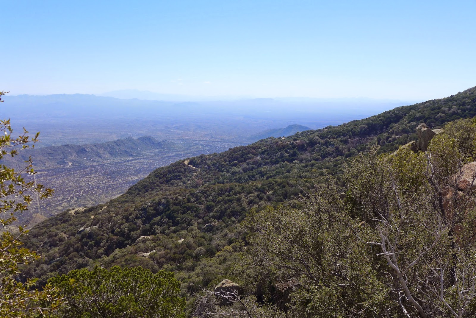
Tucson from the summit looking over the 2003 Aspen Fire burn area.
Mt Wrightson (where we rode yesterday) and Mt Hopkins just to right in distance.

The Cookie Cabin. Rebuilt after the fire. In fact, the whole town was rebuilt.

An inch thick and piping hot from the oven. Oatmeal Raisin.

Peanut Butter.

Isaac heading up to Mt Bigelow.

View east from Mt Bigelow.

Descent from Mt Bigelow.

Very chunky terrain. Bugs later stepped it up a few more notches.

Tuesday, March 10, 2015

From Freezer to Frying Pan: AZT 50 Miler

Hit one of my favorite sections of the Arizona Trail (AZT) today, roughly from Mt Wrightson to where it crosses Rt 183. Isaac and I started out on pavement, heading south on Rt 183. Pavement gave way to dirt, jeep road initially, at the 17 mile mark. There was a fair amount of climbing to get over the pass at around 5200ft elevation. Isaac pulled my sorry butt all the way up there.

Not even a mile from the car, I was futzing with my GPS. It was not working. I was on the negligible shoulder of the road not looking forward. Without warning I crashed through a thorny bush (there are no other kinds in the desert) that was overhanging the shoulder. Just like that, I had bloody streamers running down my right leg. Glad I could provide entertainment for Isaac.

Garmin's are notoriously temperamental. I've had good luck with my 510 until now. Worked perfectly Sunday. Monday morning, FUBAR. The GPS function itself would work, meaning it could show me where on Earth I was, but none of the cycling/computer/data recording functions worked. First full day of a trip where GPS navigation is crucial. SOB! It's bad enough when you lose data for an epic ride, but it looked like I was screwed for the whole trip.

But that was only the beginning of the climbing. Once on the AZT, there are innumerable drops into washes with steep climbs back out. This took a huge toll on me, with so few cycling hours in my legs. I'm sure Isaac was loving it. There are a lot of sketchy switchbacks too, several of which I dared not attempt. Why are right-hand switchbacks so much more challenging to me than left-hand?

I extended the loop this year from all my previous rides on this section of the AZT by picking it up much further south. The added content is a keeper. Climb to a higher elevation, about 5800ft closer to the Mt Wrightson Wilderness, before a ruckus singletrack descent we both liked. (Strava track)

The prized part of this ride is the last 10 miles which steadily lose elevation on buff, rollercoaster singletrack.  Isaac said his cheeks were hurting from smiling so much. Yeah, it's that good.

After a couple hours surfing forums, I regained some functionality of my Garmin 510. Had to reformat, as in storage device FAT formatting. It still behaves bizarrely when Windows attempts to mount it, but I was able to capture a track and upload it to Strava. We shall see if it works for a 6-7hr ride planned for Tuesday.  Anyway, it is late, so I'll leave you with a few photos.

High point of the ride, looking towards, maybe into Mexico.

Isaac at high point with Mt Wrightson Wilderness in background.

Nothing but cooler temps and grasslands up here above 5200ft.

Many miles of steep, gnarly terrain.

Approaching switchback none of us can clean.

The ripping smooth last 10 miles.

Saturday, March 7, 2015

Abrupt Transistion

What a ski season it has been, and it is far from over. This past Tuesday was the last points race at Weston. I skied six of the seven points races. An eighth race was cancelled due to a blizzard. The Tuesday Night Worlds, as some call it, were a staple of my fitness routine for most of the last two months. With ample snow and a long course set up, I could expect to suffer mightily for 25 minutes.

There is mounting evidence that intensity, not volume, helps older athletes slow the inevitable decline in fitness metrics. After reading excerpts from Friel's new book, I'll have to pick up a copy. Weston, and Nordic skiing in general, places very high demands on the cardiovascular systems, certainly way more than I could ever experience on an indoor trainer. And ski racing with another 80-90 like minded crazies is a heck of a lot more fun than stuffy go no where indoor routines.

My performance is becoming more consistent across a variety of conditions. I wouldn't say this was a break-out year for me, but I have been finishing closer to the front of Weston races and just posted my fastest time at Rangeley. I guess when cycling is almost impossible outside with the weekly blizzard series we had this year, there is nothing to do but ski. It should be no surprise this brings about more consistent results.

On Saturday, I hooked up with long time no see Dave Penney for a skate at Waterville Valley. You'd never know the last time Dave skate-skied was almost two years ago. Conditions were almost as good as they get. Firm, maybe a tad squeaky due to low overnight temp, and mint weather.

Yes, Dave is still alive. Top of Upper Snows looking at Thornton Gap.

Myself coming around Bob's Lookout. Snow still almost up to top of picnic tables.

It's time to start thinking about cycling again, transitioning ski hours to ride hours. But how do you do that when there is still 30" of snow on the ground and roads are too dangerous to ride? Head to Tucson, Arizona for a week.

With any luck, on Sunday Isaac and I will get in a short ride in Saguaro cactus forest before the sun sets. Then it is a full week of desert trail riding with temps soaring into the 80's, some 80 degrees warmer than my last MTB ride. I've never gone into a week of huge volume with so little hours in the legs. I've barely average 2hrs per week for a couple months. This will be the most abrupt transition to riding I've experienced, both in temperature and in volume. We have some 100km+ rides mapped out. Going to be tough staying hydrated. We'll go from a cold dryness to a dry heat. Some will argue you dehydrate just as quickly in the cold as you do in the heat. I don't know. I've never chugged a 32oz bottle of Gatorade without coming up for air in the cold like I did after a ride in the desert one time. Really looking forward to it. The skiing has been great, but I miss the bike.

0% precip for the week and almost too hot. I'll take it.