I've always wanted to ride an Alpine Tunnel loop that straddles the Continental Divide. Lots of history in this area, and plenty above tree line riding. The Alpine Tunnel was a rail tunnel through the Continental Divide. The rail line wasn't in service that long, and eventually the tunnel collapsed. The rail grades are now trails. Much of the area is open to motos. I don't have a problem with that, as there are jeep tracks that visit some pretty amazing areas. Motor vehicles can make more challenging riding terrain though.
Another feature that caught my attention more recently in this area is the Canyon Creek Trail. Mountain bikers rave about this 3000+ foot descent on singletrack. You have to earn this one. There is a massive ~1000ft vertical hike-a-bike before beginning the plummet. Yet many suffer this slog for the descent. I knew there would be one other hike-a-bike (HAB) on this ride. It goes over the divide at the collapsed tunnel. This one was only a few hundred feet, so tolerable.
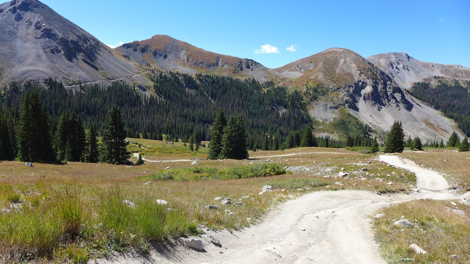
Starting out from the Snowblind Campground on FS #888, the well maintained dirt road was a breeze to climb, ignoring the fact there was no air to breath at 9200ft for a low-lander like myself. Once past the settlement of Whitepine, the road became more interesting. It got steep and more closely resembled a creek bottom. This would be a taste of much to come.
Tomichi Pass was the first hurdle to clear at almost 12,000ft. I might have ridden all of it. It was early in the ride. Looking over the other side, I see another pass with a road that looked like it went right up the fall line. I hoped that wasn't my route. I bomb down the back side of Tomichi, then dread begins to set in as I realize that indeed my track goes over that road I saw, over Hancock Pass.
Almost immediately, I ran out of gas on the cantaloupe chunder. At altitude, this low-land dweller had only 50% power available. Then apply that to chunder on big double-digit grades, another 50% of what's left is wasted. That leaves only 25% to get work done. Upward progress was painfully slow, especially pushing a 28# bike with a 22# pack. That is 50# of crap to take with you up steep, loose grades.
Eventually I reached the 12,140ft Hancock Pass on the Continental Divide. The views were pretty sweet, and looking back at Tomichi Pass struck fear in me. I'd have to climb back up that after riding the Alpine Tunnel loop.
I was looking forward to a rip down back side of Hancock Pass. Rip, it was not. This was some of the nastiest chunder I've ridden. Not only did climbing take an eternity, now the descents were a slog too. What did I get myself into?
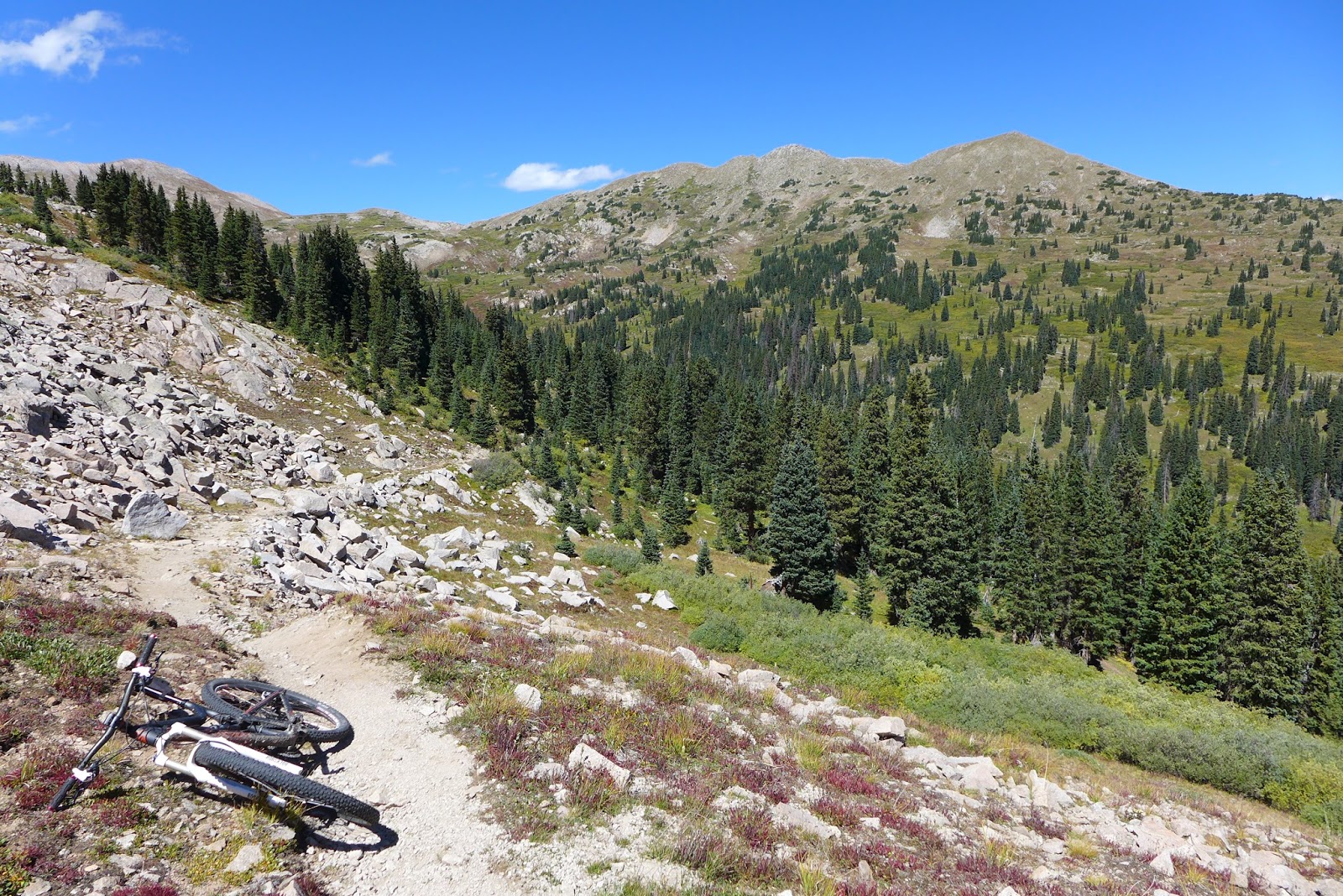
When I finally dropped down to the Alpine rail grade after more than 1000ft vertical of chunder, I could finally take a "breather." The rail grade was closed to motos and climbed at a modest 2-3% grade.
At the collapsed tunnel, I had to get back over the divide to close my loop. A trail connects both sides of the tunnel over the divide. There's a reason the railroad engineers tunneled through the divide. It is some steep-ass shit! I knew this would be a chunky hike-a-bike from reports I read. At least it was over quickly and the west side was mostly rideable.
There is a rail station on the western portal, called Alpine Station. A few bits are preserved with interpretive signs. Seems so out of place, middle of nowhere, and so high up. A few miles of bombing down rail grade brought me back to the bottom of Tomichi Pass, which I now had to climb back over from the north, nearly 1000ft gain. Intermittent bouts of HAB ensued. I hadn't even gotten to the mega-HAB yet.
From Tomichi Pass, I looked over to the big dome that Canyon Creek Trail goes over. How hard could it be? Didn't look that big. However, in big sky country, everything is bigger and further away than it appears.
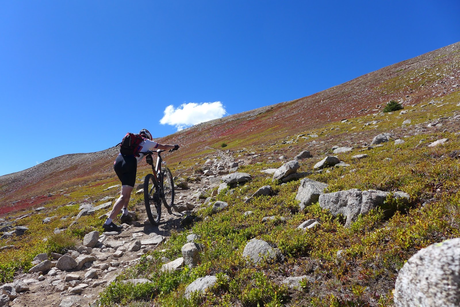
I was almost immediately off the bike heading up Canyon Creek. From tracks, it looked like some rode parts I was walking. Then I got to a chute of chunder that would have been difficult to even hike in good hiking shoes. Hiking it with metal cleats and 50 pounds of crap? Death march! Then I looked up and saw a silhouette far above, pushing a bike. WTF, that guy is so tiny and so far away. Funny how something like that suddenly puts perspective on what you're up against.
I kept plugging away. I deliberately brought two pairs of MTB shoes on my trip so I could destroy an old pair on this ride. As I climb, the views became more and more impressive. This mountain, for which I could find no name, stands off by itself and offers incredible 360 degree views. The summit looked a lot like Mt Washington summit, a big rock pile of lichen covered granite. I had the summit to myself, the other riders having left before I got there. It was very windy, but very comfortable at 12,500 feet on this September day.
The descent starts a little bony off the summit cone. But once on the alpine meadow, it was a buff speed fest. Yeah, this was starting to make that 40 minute HAB worth it. The trail pops back into tree line and gets even better as it follows the canyon down. Endless roller coaster is the best way to describe this trail. Every time it leveled out for a bit, I'd think wow, that was fun, only to find it rips down a whole bunch more. Canyon Creek is one of those rare singletrack descents that gives you descent fatigue.
I passed a very large group on the way down, the first and only cyclists I encounter on this all-day ride. They got a bit spread out, and some waiting further up the trail asked if I was with the bachelor party. Um, no. There must have been 20-25 guys and gals in that group. When I started my ride, there was only one other car at the trail head. When I got back, maybe over 15 cars.
Near the bottom there is a PUD (pointless up and down, a hiking acronym) that about killed me. I had been out of water for an hour and didn't feel like stopping to filter from a stream of dubious quality. 300+ feet up steeply, with some more HAB for good measure, only to give it all back just as steeply. Then there the car was. A great ride, very satisfying, but one I'd modify when repeating.
No altitude sickness this time, thank goodness, as most of the ride was above 11,000ft. Big photo dump follows. There was not a dull view in this ride. 34.5mi, 6650ft.
 |
| Many stream crossings heading up Tomichi Pass Rd #888. |
 |
| Once I got past the settlement of Whitepine, much of the rest of the ride was chunder |
 |
| Heading up to Tomichi Pass |
 |
| View south from Tomichi Pass |
 |
| That is Hancock Pass, next climb I hit. Looks like it goes straight up, which it does. Unbelievably difficult. |
 |
| Tomichi Pass |
 |
| Some mining ruins between Tomichi and Hancok passes |
 |
| Heading up Hancock. Power output was half due to altitude, the half of the remaining half was wasted spitting cantaloupe sized rocks out from your rear wheel. |
 |
| Looking back at Tomichi Pass, which I'll have to climb again much later in the ride |
 |
| Hancock Pass on the divide at 12,140ft |
 |
| Looking up Hancock Pass Rd. Glad I was going down, but still barely rideable. Forget about any speed. Zero payback on all that HAB. Was literally creek bottom much of the time with water flowing down it. |
 |
| Looking down Hancock Pass Rd |
 |
| Finally a non-moto trail. See the difference? This is Alpine Tunnel trail, an old railroad grade |
 |
| Valley from Alpine Tunnel RR |
 |
| Alpine Tunnel |
 |
| The tunnel caved in many years ago, so there is now big HAB trail over the divide |
 |
| Back on the divide above Alpine Tunnel |
 |
| At least most of the descent was rideable from Alpine Tunnel divide |
 |
| Tunnel closed off. Trail went over divide above it |
 |
| Turn-table |
 |
| Alpine Station |
 |
| Only preserved building at this station |
 |
| Alpine Station ruins |
 |
| Granite wall where rail grade was blasted out of cliff |
 |
| Looking back up Hancock Pass later in day with different lighting |
 |
| Heading up Tomichi Pass for the second time. At least most of it was rideable. |
 |
| Canyon Creek hike-a-bike. This was so steep you needed hand holds and would take step up and slide back two. |
 |
| Summit of Canyon Creek Trail. Can you spot the rider pushing his bike nearly 1000ft above me? There might have been F-bombs... |
 |
| Maybe now you can see the rider. |
 |
| Ugh! The never ending stumbling drunk hike-a-bike. |
 |
| Looking back down the Canyon Creek HAB |
 |
| Getting closer to the Canyon Creek summit. Still pushing |
 |
| One of the Canyon Creek HAB switchbacks. At least the views don't suck. |
 |
| Panoram from enar the summit. Nearly my entire ride in one gaze. Tomichi Pass right of center, Hancock Pass left of center, Alpine Tunnel on left. |
 |
| Zoom on Alpine Tunnel from top of Canyon Creek trail |
 |
| Hancock and Tomichi Passes from top of Canyon Creek |
 |
| Summit looked just like Mt Washington, a big rock pile. |
 |
| Top of Canyon Creek trail. Anybody know the name of this peak? About 12,500ft. Very windy but a warm day for September. Totally digging the weather. |
 |
| The express train down. This is what so many suffer 30-40 minutes of hike-a-bike for. The Canyon Creek Trail descent. 10 miles, nearly monotonic, 3000+ feet drop. |
 |
| Canyon Creek |
 |
| Looking back up Canyon Creek to the bald dome |
 |
| View south from Canyon Creek Trail doesn't suck |
 |
| Canyon Creek Trail wrapping down around this bowl. Looks like contour, but it is ripping fast downhill. |


No comments:
Post a Comment