Sunday, November 28, 2010

Hillsborough Fuster Cluck


The photo above pretty much sums up the ride DaveP and I did Sunday. Dave was really antsy to get in a decent ride, being a freshly minted new dad. His son Zach came into the world unexpectedly early this week, but all are doing well.  I had hoped to build on the success of last week's 'cross bike ride. My route research proved less than thorough this time. The ride turned into the mother of all boondoggles.


The Hillsborough Classic mountain bike race was one of my favorites when I first started racing bikes. It was a single 32 mile loop, mostly on jeep roads and ATV trails through Fox State Forest. I thought if we stuck to named roads on maps, we'd have a reasonable probability of staying on our CX bikes in this area. I should have known not all would go well. Cathy and I tried to hike Mt Cardigan on Saturday and did not get far at all. It was crampon conditions right from the parking lot. There was an inch of conformal coat ice on everything. This is much further north than Hillsborough, but the higher elevations around Hillsborough did not escape Friday's freezing rain. To compound matters, an inch of snow fell Saturday night. This meant you could never tell what lurked below.

It was 23F when I left the house and only slightly warmer when we rolled out of Hillsborough at 9am.  We started out on Center Rd, climbing several hundred feet along Fox State Forest on pavement. Pavement soon gave way to gravel. An ominous sign (as in Dead End) welcomed our right hand turn onto County Rd. It was great riding for a while. Eventually it petered out to rough double track. We soon learned why. Beaver activity, probably long ago, put a lengthy section of this "road" under water. The ice wasn't quite trustworthy enough to walk across. A bush-whacking we went. We got far enough off my GPS track that I wondered if we could even get back to it without crossing this great chasm of wetlands in our way. We did get back on track, but not without getting torn up by briers.

County Rd starts out innocuous enough

We were higher up now, and random ice flows were becoming more frequent. This made climbing the 20+% grades without studs quite frustrating. Next up was W Dunfield Rd. This was a "bonus" 500ft climb. We could have gone straight and fared much better, but no, I had to take us on a highly suspect road that showed up as a trail in DeLorme Topo. Google Maps showed it as a through-road, but barely there in satellite view. Since I pummelled my body all week, I told Dave to go ahead and get an interval in if he wanted. He didn't go far before the road dead-ended. Hmm, track says road should be right... here. It was, barely. We started riding on a crunchy frost heaved surface that would collapse under our skinny tires. It got progressively steeper. The snow got deeper. The ice got more solid. Needless to say, we gave up and shouldered the bikes. We gained a couple hundred feet this way. To our horror, the descent was even less rideable. It sucks even more to hike down. It basically looked like a creek bottom. Nothing but rocks and ice. The trail continued to peter out. If it weren't for my GPS track, we'd surely have gotten lost.

Coming up West Dunfield Rd

It was a relief to see a house. The initial north facing gravel descent was insanely steep. The view of the Sunapee range was quite spectacular. Little did we know that there was hockey ice under that dusting of snow. Dave was so kind to point this out as he ditched his bike and went chest surfing down the hill. How I stopped without going down is beyond me. Damage: banged up elbow and bananas ejected from jersey pocket. I think I went 4mph the rest of the way down that hill, which normally could easily be taken at 40+ mph.

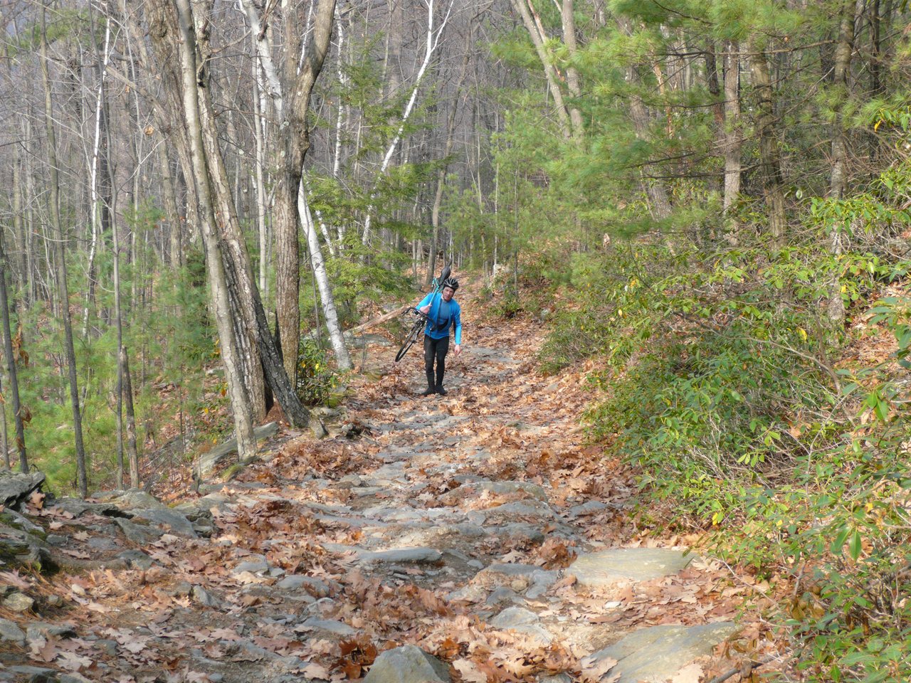
A left at the bottom had us on pavement for a bit. This kinda sucked. It was salted, so a sloppy mess. Our bikes were clean until that point. The pavement gave way to gravel again. The road was nice for a bit, veered right, but oh, my track goes straight on another gory looking jeep track. This one really sucked, as it was even steeper and gained 900ft. We hiked most of that vertical on Old Mountain Rd. At the top, our average speed for the ride had dropped below 9mph! This was supposed to be a three hour, 43 mile ride.

Old Mountain Rd where it leveled off for a moment

Coming over the top was not much of a relief. There was a lot of ice under that snow. My rims had frozen up again. Cantilever brakes suck when performing at their best. Let them freeze up, you have nothing. I was using my feet to control my speed. A little further down the descent levelled out a little. I reached a flat spot where I thought, wow, this is really smooth here. About the same instant I realized I was riding on ice, I was bouncing off said ice. I must have used my left kneecap to test the hardness of the ice. The ice was solid alright. My knee hurt so badly I could have hurled. Of course, Dave was behind me and found my sprawl across the ice quite entertaining. I had enough wits to throw him my camera while I was still writhing in pain.

We shortly picked up a gravel road that saw a little traffic. This was finally rideable without fear of death. It was mostly south facing, and the frost was coming up. It was a juicy mess. The rollers meant it was also a lot of work in puddy material.

We crossed over Rt 31 and rode along Highland Lake next. There was yet another uncertain connection here. Google Maps doesn't show East Shore Dr going through, where Topo did. Turns out the segment in question is on conservation land, and it appears the locals that live on the lake maintain a nice path through the woods here to access scenic Pickerel Creek Pond. This was close to riding singletrack. It was uber steep at the top, but doable. Crossing another gate on the other side, we were back in business on gravel road.

Pickerel Creek Pond. Bring out the hockey skates!

Old Antrim Rd is a cut-through to Rt 9. All maps show it as an auto road. It wasn't. About a mile in (all up, of course), it was under water. Neither of us were in the mood for another massive bush-whack. We cut our losses, turned around and took pavement all the way back to Hillsborough. Busy Rt 9 was not the most pleasant way to finish the ride. I was riding on fumes for much of the ride, so Dave towed my sorry self back.

We finished the ride with 48.5 miles in 4:14 hours riding (and hiking) time on the odometer. The baro altimeter says we did 4760ft of climbing.  The loop Dave and I did from Keene last weekend was a keeper. Today's loop will be relegated to the half-baked rides folder. I don't think there is any way to tinker with it to salvage it. There just aren't other through-routes in this area that aren't paved. Hopefully Dave got something of a workout. I got more than I bargained for.

Friday, November 26, 2010

Frozen Turkey Burner


I haven't missed the FOMBA Turkey Burner for at least as long as I've been keeping a cycling log, since 2002.  Today I've come the closest ever to bailing, seeing nothing but pink and dark green on the radar maps when I got up. The night before, Steve G and I decided to wait until 8am on whether to pull the plug on the T-burner this year. The forecast was not good. 8am rolls by, nothing from Steve. Finally I send out a feeler email. No way was I going to bail first. I think he was waiting for me to bail, and I was waiting for him to bail. Funny how that works. Of course, neither of us bailed. I sensed another dose of character building was going to be administered while driving up the Everett Turnpike. It was 32F, raining, and the pine trees were caked with ice.

There were actually more than 2-3 cars at Massabesic Lake. Last year it was 10F warmer, pouring rain and fewer cars than today. We did score a small break in the rain while registering and kitting up. It always sucks more to actually start out when it is raining. I went back through my log to see how prior years compared. Here's what I found:

2002  3" snow, hooked up with Phil Keyes
2003  40F, drizzle changing to downpour
2004  30F & Windy. Scott N broke Elbow on ice under leaves.
2005  17F & 4" of snow
2006  50F, greasy trails
2007  33F, greasy trails
2008  32F & sleet
2009  44F & pouring rain
2010  33F & freezing rain

So out of the last nine years, there were only three decent years where it wasn't raining or no snow on the ground. This year it had rained all night, so there was plenty of standing water. There was no point in even avoiding it on the double track sections. We scooped up Joe Reagan at the start, so we had a nice three man posse heading into the woods.

Seems riding with Steve this year has gone no where good for me. Ankle fracture in May, then on the x-ray table again a couple weeks ago. I've very nearly recovered from the most recent injury. That meant I was due for another mishap. What better way to maximize the probability than riding on slimy roots and rocks for three hours? I put a governor on speed but wasn't afraid to burn matches every now and then on short climbs. The Fireline trail seemed to take an eternity. Nearly cleaned it though. I was riding quite well as long as I focused on technique and not speed.

After a speedy romp through Woodpecker, Long Trail was next. It used to be the longest trail until fireline was extended to over three miles. Long trail offers the most opportunities for bad things to happen. I managed to not hit the deck and escaped with just two dabs. Another group was kind of loosely hanging with us the last 30 minutes or so. Some were frigid. Joe seemed just a little too eager to show them the direct way back to the cars. We still had eight more singletrack loops to hit. Now it was just Steve and I.

Lots of close calls over the next several trails. We passed another group of two, then there were no more tracks in the mud. We were on the vanguard. Or whacked. Everybody else might have wizened up and bailed. Steve could no longer feel his brakes or shifters. I wore lobstah mitts and was still doing ok. We both had baggies and neoprene booties on our feet. My feet stayed dry for the whole ride. I could squeeze water out of my mitts though. Everything else was saturated too.

Steve set a pretty hard pace starting out, so I was not going to let him bail early (like last year). He was going to finish the whole ride this time. He bonked pretty spectacularly on Fisher Cat. A Power Bar brought him back to life for the last couple loops.

We finished 28.1 miles in 3:05 riding time. There might have been only 2 or 4 biker cars left in the parking lot when we got back. It figured the sun was poking through just as we finished the ride. Well worth heading out. The Turkey Burner streak holds for another year.

Wednesday, November 24, 2010

Lamenting Dyna-Sys

There is huge churn in the world of bicycle standards these days. For most of my years as a cyclist (about 14), things like head tubes, bottom brackets and handlebars were standardized. Head tubes on frames were set up for 1-1/8" head sets. Bottom bracket shells were 1.37" with 24TPI. Bottom brackets themselves were square taper.  Handlebar diameters were about 25mm. Now we have all types of integrated headsets and even different diameters top on bottom. When bottom brackets went external, some genius figured out that wasn't such a good idea after all, so now we have multiple integrated bottom bracket standards. There are now two popular handlebar diameters, one creatively named oversized.

I've been pretty much a life-long Shimano devotee. My first bike when I became reacquainted with cycling back in 1996 came with Grip Shift controls. I moved to New England a year later, and every bike since, about 16 bikes in all, has been Shimano equipped.

One thing I really came to like about Shimano was they held the actuation ratio constant among almost everything they sold. Actuation ratio is the ratio between how much the rear derailleur moves vs. how much cable the shifter moves. Until now, Shimano was claimed to have a 2:1 actuation ratio. This means the derailleur moves 2mm for every 1mm the cable moves. I measured this on a bike, and I get something closer to a 1.6:1 ratio. Shimano doesn't publish this anywhere.

A universal actuation ratio is important for me as a hillclimber. This allows me to mix and match road and mountain bike components. As long as the number of shifter clicks matches the number of cogs in back, it will work. I could shift mountain bike XTR derailleurs with road Dura Ace levers or even the other way around if I wanted to be goofy. 8spd, 9spd, 10spd, it didn't matter. Clicks = cogs, it will work. Three of my bikes with road shifters have mountain bike derailleurs on them right now, my hillclimb bike, cross bike and my all-around road training bike. I never need worry if my gearing is suitable for a hundred miler with 20% grades in it.

When Shimano first adopted 10spd road gruppos, it messed things up a little, as if I wanted to "upgrade" my hillclimb bike to 10spd, I didn't have a suitable MTB 10spd cassette to put on back. Sure, folks like IRD made a Shimano compatible 10spd cassette with some pretty big cogs in it, but it weighed a ton of bricks, being stamped steel. It was wait and see if Shimano came out with 10spd drivetrain for off-road use.

Personally, I think 10spd is stupid for road and even stupider for off-road. When MTB drivetrains went from 8spd to 9spd, problems with chainsuck quadrupled and things wore out twice as fast. I really didn't want to see Shimano come out with a 10spd drivetrain, as that probably meant 9spd would go away and my bikes would be left with orphaned drivetrain components. I can only imagine how much more 10spd will cost, how much shorter it will last, and how much less tolerant of mud it will be.

Well, Shimano not only introduced 10spd MTB drivetrains this year, they changed the friggin actuation ratio too! They call the new gruppo Dyna-Sys.  This means I will not be able to mate a new 10spd Shimano derailleur to my 10spd road shifter. Shimano reduced the actuation ratio, which means the shifter must move more cable per cog. This also means you cannot backfit any older 9spd stuff with 10spd shifters or derailleurs. You gotta replace the whole deal - shifters, derailleurs and cassette.

I can't really blame Shimano for doing this. To make 10spd work in an off-road environment, they had to make this change. 10spd gear changes with the old actuation ratio would mean little more than a millimeter of cable pull to effect a shift. That is pretty fussy. No idea what they new ratio is. All Shimano says about it is the derailleur uses new "Long Arm" technology, which simply means they put bigger lever arms at the cable/housing attachment points on the derailleur.

SRAM went to a 1:1 actuation ratio in their 10spd off-road stuff, calling it "Exact Actuation." At least they tell us what the ratio is. I've occasionally ridden SRAM drivetrains over the years on rental and borrowed bikes. I've never been very impressed with the shift feel. This is especially true for their road indexing. I haven't tried the newest off-road 10spd shifters yet.

I'm betting Shimano will jump on the 11spd road bandwagon soon. When will this madness end?  If Shimano does, I suspect they will roll the new actuation ratio into 11spd. This would bring a little harmony back into the drivetrain realm.

Sunday, November 21, 2010

The Other Pisgah

It was another fine weekend for exploring New England on cyclocross bike. DaveP and I headed over to nearby Keene, NH for a 56 mile loop around Pisgah State Park. Mountain biking opportunities are still limited within New Hampshire's largest state park, but that could be changing soon. Neither of us have done much riding in the very southwest corner of the state. It is quite mountainous and sparsely populated. The first couple hours of our planned route would be anything but mountainous, however.

Earlier in the week, Dave pointed out a rail trail near his house and wondered how we might loop in some dirt roads for a CX ride. I poked around on the web a bit further and found there is a vast network of abandoned rail lines around the state. Particularly interesting was a near loop in the Keene area. I've done the triangle in Manchester already, but it kind of sucked due to one leg being open to ATV traffic. The trails in the Keene area are closed to motorized wheeled vehicles. The three rail trails on the loop are dirt, but I had no intel on surface quality. Illegal ATV used can muck things up. Lack of maintenance can foster muddy areas or overgrowth. This ride would surely be an adventure.


Saturday turned out to be a much better day to be in the woods than on the open road. It was feeling more like winter and it was wicked windy. We parked at the Shaw's right off Rt 101 in Keene, where the Ashuelot Rail Trail can be picked up from behind the building (some references say it is pronounced Ash-we-lot). 21 miles of flat to slightly downhill did not mean it was easy. The surface varied from fast hard park, sandy, rocky to grassy. There was only one brief muddy spot. It was steady tempo work with no recovery for nearly two hours. It was perfect for cross bikes on a cold autumn day.

The Ashuelot Rail Trail along rushing river by same name

The Ashuelot trail merges into the Fort Hill Rail Trail at the Connecticut River. We took a 180 degree turn to head north right along the east bank of the river. Very scenic. This 9 mile section terminates at a major bridge over the river with rails still in place. Reports say it is unsafe to even walk across. We planned to stay on the NH side of the river and take a short bit of Rt 119 to Wantastiquet Mtn. A dotted line on a map caught my attention here. It was described as a wide hiking path. Were bikes allowed on it? Was it even rideable? It gained 1100ft in less than two miles. That is pretty steep, especially for biggish geared CX bikes. Dave was running 38mm city slick tires. I had knobby 35mm tires.

It was a CX ride after all. This is Wantastiquet Mtn.

There were no signs at the bottom, just an iron gate. The path looked like a maintained fire road. We were game. It started harmless enough. After two switchbacks (there are 10), we hit our first hike-a-bike section. Another switchback, the hike-a-bike became more intense. A older hiker presumably with his grandchild commented that I must be incredibly fit or lack common sense. Couldn't it be both?  We reached a point where more than half the vertical was gained, so we decided to finish the deed no matter what. In hind sight, probably not a good call. The last half was more hike than bike. The view up top from a rocky knob was quite good though on this hazy overcast day.

Brattleboro, VT from summit of Wantastiquet Mtn

I have been babying an injured leg, and a ride of this duration was questionable in the first place. I conned myself into thinking it was ok, as I would only be riding, not going too hard, and riding doesn't entail much calf muscle effort. Well, this climb completely blew my shaky thinking out the window. The descent scared me. I had no ankle supports on. It was all loose rocks, water and oak leaves with nylon soled booties. I had ZERO traction on anything I stepped on. The descent was a rolled ankle ambush waiting to happen. It seems eccentric muscle contraction really aggravated my calf injury. I was using my bike as a crutch. After reaching the bottom, I fretted over how many days that was going to set me back. I opted out of doing the Velocross CX race on Saturday to give my leg more time to recover. Can't say this was any better than racing for my leg.

Gulf Rd

Continuing north along the river, we followed a few miles of gated fire road before picking up Gulf Rd. Gulf Rd was a real gym. It is essentially a one lane gravel road through a gorge with a rushing stream along side it. It reminded me a lot of Kelly Stand Rd in southern Vermont. We gained about 600ft on this road, climbing into the Pisgah mountains just north of the state park. Dave had no mercy on me, setting a pace to surely punish me for whining about my leg. The next ten miles repeated a pattern of climb a couple hundred feet, descend a hundred feet, on mix of gravel and paved roads. We rarely saw cars. I was pretty spent when we finally reached the high point before beginning the descent towards keen.

Wantastiquet Mtn climb (3x vertical exageration)

Shortly after crossing Rt 9, we hopped on the Cheshire Rail Trail for the last few miles, still downhill, back into Keene. The ride took 4.4 hours and entailed about 3500ft of climbing, nearly all of which was in the last 24 miles. Certainly something I would do again on a cross bike, minus the Wantastiquet climb. It's a great loop to get away from people and see parts of the state you wouldn't normally see.

Monday, November 15, 2010

Mt Kearsarge Rollerski Hillclimb

My doctor would have made me another doctor's problem if he knew what I did just a few days after seeing him with a potential leg fracture. Rollerskiing up a mountain is one of the most abusive things you can do to your body. At least I experimented on rollerskis Saturday to see how my leg would respond. I was pleasantly surprised to find that skate boots laterally immobilize the ankle joint and reduce the level of discomfort I experienced while raking leaves all morning. That was good enough for me to give the timed climb a try.

I had benchmarked myself on Kearsarge a couple weeks earlier, a non-serious ski up to see how hard it really was. It took me about 36 minutes. I figured I could readily take a couple minutes off that in a more serious attempt.

It was a fabulous weekend - dry, mild, calm winds. For the second of two CSU organized races, classic rollerskis would be used by most of the gang. I use only skate technique these days. There were a number of us planning to use skate technique, so Brett Rutledge and I would not be the only ones.

About 30 minutes before race start, Albert and John came down the road and said "we have a problem." The park toll road is closed for the season, and it seems wind has taken some trees down, some really big trees in fact. Cars were not going past the 1.4 mile mark of the 3.4 mile climb. If skiers were to go to the summit, there would potentially be multiple ski dismounts and who knows how much debris to trip on for the last two miles. And we'd have to walk back down in ski boots. This simply was not a viable option. Race organizer John recommended to move the start below the park entrance to the last downhill on Mountain Rd. This would put 0.9mi and a few hundred feet of climbing back into the course. The race turned out to be about 2.3 miles with 960ft of climbing. Was I disappointed? Yes, mainly because I would not learn what I could do relative to my benchmark two weeks earlier. But this would still make for a pretty grueling 20 minute effort.

Garmin Edge 705 data.
Modified course profile. Toll gate was around mile 0.9.

I used my Pursuit rollerskis with some pretty worn down tires. The pavement on the public road was exceedingly rough and I had great difficulty skating on it. The roughness was so bad that sometimes a ski would stall out on the steep parts. The toll road inside the park was recently repaved, so it was sweet skating.

This was my first rollerski race.  Uphill rollerski races are about as exciting as uphill bicycle races. Not very. You quickly go into a personal world of hurt and stay there until the top. The usual things happen. A few people go out way too hard and implode just as hard three minutes later. The really fast guys are out of sight in a few minutes, not to be seen again. The rest of us just settle into our groove and slowly spread apart from one another. When I reached the finish, I hadn't seen anyone in front of me for some time. There were two not far behind. I thought to myself that felt just like an Ascutney climb or a Weston sprint race. It hurt pretty dang bad. Just the endorphin fix I needed.

I figured that since I couldn't compare my time from two weeks ago, at least I could do a relative comparison against Brett. But he was many minutes back. I knew something was up. Of all things, he flatted during a rollerski hillclimb race! I never liked my 125mm V2 Aero's. His 150mm V2 Aero's are much more reliable, but not this day. He finished, although at extraordinary energy expenditure. I had no reference at all. I finished in 22:40, which was second out of eight skaters and 5th out of 22 total skiers. Talking with a couple skiers that skated two weeks ago and classic skied this week, the consensus was classic is faster. I'd like to believe that. I got smoked by a 14 year old junior on classic rollerskis.

My form 0.1mi from the finish was horrible. I arrive in the video below at around 57 seconds. I'm probably babying my sore right leg. I'm dropping my left shoulder. My pole plants are way too wide. I was just dying at this point. A spectator yelled "tenth of a mile to go," but I thought he said half of a mile. I almost blurted an expletive but asked again how much and heard only a tenth of a mile.


Video by Tom Smith

Despite an abbreviated race, it was still worth heading up there. Probably not the wisest thing to do nursing an injured leg. No way I could have gotten that kind of workout raking more leaves. Before rigor mortis set in my leg, I hopped on the mountain bike from home and hit some ATV trails I hadn't ridden in years. Managed to get in 21 miles in two hours before the light waned. A good day.

Loop from my house just dipping over the state line in lower left
corner. Still possible to put a 30 mile loop together here with
minimal pavement contact, although new developments are making
this harder.

Saturday, November 13, 2010

Without a Leg to Stand On

As Steve Gauthier and I were rolling out of the parking lot Wednesday, Jim Kingston drives by and rhetorically hollers to me "didn't you learn anything this spring riding with that guy?" Steve and I were headed into Mine Falls on our lunch break. I had my newly repaired Titus daulie back on line finally. I had no idea how ominous Jim's comment would be.

Like usual for the past few weeks, I was riding a tad tired. I did a hard 65 minute rollerski workout the day before and hadn't really recovered from the weekend. I typically have an aerobic superiority over Steve, as he's a track specialist. But this advantage has diminished recently. He's been doing a lot of sculling on the Merrimack river. I've also learned over the years that guys who've raced motorcycles, whether track or off-road, tend to have superior handling skills in the woods. Steve used to race at Loudon years ago. I think it is a combination of genetically missing the fear gene and genuine acquired skill. So when you couple skill, lack of fear and improved cardio ability, you get somebody like national champion Kevin Hines, or Steve Gauthier to beat me up on local rides.

We get into the woods to find it deeply blanketed in oak leaves. I was still sporting girlish tires, 1.95" Mutanoraptors. I really like them a lot, but hook up in deep oak leaves, they do not. Steve was railing the turns at anaerobic effort. I was making all kinds of mistakes trying to stay with him. This is exactly how I was riding back in May when I shattered my left ankle.

A tricky section near the Mine Falls Dam got a bit more tricky this summer due to a blow-down. Steve had crashed there a few weeks ago, narrowly escaping serious injury. I had ridden through that section a couple times with no issues. On Wednesday though, somehow I ended up in front of Steve in this section and didn't want to slow him down. I went a little faster than I would have riding alone and botched the maneuver. Of course, was going to dab to the right, which meant I was going for a big tumble into rocks.

I got my right foot out but had no chance to ditch the bike. There was nothing but air to put my foot into. It was a big drop to rocks and tree debris. It seemed I had eons of time to ponder how badly this was going to suck. My leg promptly crumpled and I rolled into rocks. It was one of those situations where one assesses bodily parts before moving anything. My knee hurt. My right ankle, my GOOD ankle, hurt a lot. Amazingly, things like my back, shoulders and pelvis missed the pointy rocks. I surmised my ankle wasn't broken, but I couldn't stand for a while. My whole lower leg was searing in pain. A fractured fibula crossed my mind. This is the little bone that doesn't bear much weight.

I was able to get riding again in a diminished capacity. It hurt a lot to put any pressure on the front or side of my foot. Doing so sent stabbing pains down the outside of my lower leg. We finished the ride. I took a small handful of Ibuprofen when I got back to the office. I couldn't find any localized pain, other than both my knee and ankle were moderately swollen. My plan was to see how I felt in the morning and decide then if I needed to go in for xrays. Jim Kingston was right. I hadn't learned a thing.

Being the stubborn idiot I am, I packed a bike Thursday morning. I figured if I could ride trails back from my mishap on Wednesday, I couldn't be seriously hurt. But as the morning dragged on, I realized something was far from right. I could not put any weight on my right leg going up and down stairs. I called to see the doctor. I was in a state of panic, as if I broke my fib, that would kill the whole ski season. I got xrays that afternoon. Before leaving radiology, I had to know if there was an obvious fracture or not, so I asked the xray tech if I might have a look before leaving. She was totally cool with that. My fib looked fine to my completely untrained eye. Ankle looked good too. My incident in May had bones at almost right angles. None of that this time. I felt some relief already. Of course, a radiologist still had to review the images to make a diagnosis.

Friday was a scheduled off-day. I had planned to do a big ride in the mountains, especially since it would be so pleasant out. I had no idea if I could even make the pedals go around. I wasn't going to let the day go to waste though. After getting impatient waiting for the doctor's office to call back with results, I packed a bike and headed for Lincoln, NH. A White Mountains west half loop sounded nice. This meant riding up the Franconia Notch bike path (which I normally avoid in season), bombing down Rt 18 to Franconia, climbing up and over the dirt Long Pond Rd mountain pass, then finishing over Gonzo Pass. I have pretty low gears on my Dean road bike, so I figured I could always soft pedal if my leg was too ornery.

Franconia, Long Pond and Gonzo passes

Starting out was touch and go. I could only put a fraction of the force on my right pedal. For six months now, I got used to my left leg being my bad leg. But now my bad leg was my good leg. It seemed I didn't have a leg to stand on. Fortunately, the bike path was free of leaves and ice. That would have been more than I could handle. The frost heaves were something else though. Each one would send piercing pain through the side of my calf. It seemed like one of my ankle stability muscles was f'd up. The primary calf muscles seemed fine.

Top of Franconia Notch from bike path

By the time I made it to the top of Franconia, my leg had loosened up considerably. 600mg of Ibuprofen might have helped too. Riding south to the next climb felt semi-normal. Long pond was a bit of a disappointment. It looked like frost was coming out of the gravel. Many areas were wet and had the firmness of crunchy style peanut butter. It was all rideable, but demanded 50% more kilojoule expenditure than normal. Fortunately the south side was mostly dry. It probably took me better part of an hour to ride up and over this 9 mile dirt mountain pass. Only one car passed me the whole time.

Ok, blogger picture loader is broken right now. Any other app
opens this pic rotated 90deg. Long Pond Rd, note tire imprint.

Next up was the biggest climb of the ride, 1700ft up and over Gonzo Pass. Even though it had reach low 50's in sunny areas, there was still frost on the ground on north facing slopes. I started the ride late. The sun was getting low, and the temp was plummeting. I bonked horribly climbing Gonzo. No apparent reason for it. I rode recreational pace for most of the ride. I did eat next to nothing during the ride though and ate almost no carbs the night before. Cresting the summit was heavenly. The view of the Presidential's was quite spectacular with the sun setting behind me. Bombing 40mph back to Woodstock touched on all the senses. It smelled like fall. There were pockets of ice cold air. The gravity induced wind pushed back on me. It was one of my better descents all year.


"Is it Memorex or is it Live?" Remember that commercial?
So of these two photos, which is correct? There was nary
a hint of wind in the Whites on Friday. This is Baker Reservoir.

I wrapped up with 58.6mi, nearly 6000ft of climbing, in 3:40 riding time. This was about half and hour slower than I planned. Bum leg, tricky bike path, mushy dirt climb and bonking all were a factor. On the drive back, my wife informed me the xrays were negative. Good to know after I climbed three mountain passes.

Franconia Ridge with Mt Washington in distance from
Gonzo Pass after 3pm

My injury now seems to be consistent with a pulled muscle. Anytime that muscle fires to maintain stability, my knee buckles from automatic pain reflex. Things were a little better Saturday. At first I wrote off the Kearsarge rollerski race on Sunday, but after trying rollerskis Saturday, I might be alright. It seems the laterally rigid skate boots actually help me out and I had little pain skating. We'll see how race pace goes. I might be using a lot more upper body than normal.

Monday, November 8, 2010

Whites by CX

It's transition season here in New England, that period between short sleeve riding and Nordic activities.  Many gravitate towards cyclocross competition. CX perhaps stirs more enthusiasm than road and mountain bike competition combined. Given my genetic predisposition and training habits, CX could potentially be a good fit for me. But it requires considerable handling skill, and I need some portion of the year where I need not stress over competition. I choose fall. I prefer to take advantage of the cooler temps, usually dry conditions and lack of bugs by riding off road.  No training pressures, no racing, just pure riding bliss.

Saturday Dave P and I finally hit the White Mountains on cross bikes. After two full days of rain, local trail riding was not viable.  Scouring over Google Earth maps, I scouted out some new terrain in the Whites to sample. Our plan was to hit as much back road material as possible that is not suitable for road bikes but a mountain bike would be overkill on. One of my favorite such loops is Sandwich Notch/Campton Mountain. This loop can be extended by going over Tripoli Road, but that involves a lot of paved riding for a few miles of gravel that is usually road bikeable. Another area I've never ridden is west of I-93. Over the last couple years, readers have recommended climbs on that side. My plan was to ride up Ellsworth Hill Rd, wrap around Stinson Lake on dirt road of same name, then on way back down from Rumney, pick up wildcard East Rumney Rd. I had no idea of condition of this last road. Was it paved? Did it even go through? All I knew is it had a sizable climb in it.

I suspected double track Algonquin Rd would be very wet along the Beebe River. Thus Dave and I opted to ride the Sandwich Notch loop in reverse and climb upstream along the river. This would reduce the wetness factor. It proved to be a wise choice with lots of standing water. Algonquin Rd is a gated forest service road. On Saturday, however, there was some equipment back in there brushing out a power line through the mountains. Algonquin Rd ends on Sandwich Notch Rd, which climbs more earnestly. Dave turned on the afterburners for the last few hundred feet of climbing. I called him names upon summitting between gasps. I secretly hoped he'd pay for that later.

Algonquin Rd along the Beebe River

Still on dirt, we bomb down the north side of Sandwich Notch. Pretty dicy on cross bikes at 20% grade, high speed and rutted out surface. After very brief stint on Rt 49, we're back on dirt on Chickenboro Rd climbing Campton Mtn. This is the second climb in the profile below. It's a total spanker that keeps on giving. Reaching the highest point by bike is a bit questionable. If ever asked, "I have a map that shows it as public land access." The view is nice.

Sandwich Notch on the left, Stinson lake on the right

A mostly paved descent took us back to the car to top off water and head out for stage two of our ride. Ellsworth Hill threw some deliciously steep pitches at us. MattK says he hits 55mph coming down this road. That kind of speed would seem pretty sketchy to me with blind dips and bends. As we neared Stinson Pond, the road turns to dirt and undulates. Wouldn't you know it, a town line appears when we're already pretty much tapped out. We go for it anyway. I held about a 4" lead over Dave for the longest time to the line. Stupid. We both wobbled all over the road cross-eyed after that one. This gravel section lasted only a few miles before picking pavement up around the lake. The climb offered many views to the north and east, and the lake was highly scenic too.  The gravel was well groomed with minimal traffic.

View from Campton Mtn

Coming into Rumney, we took Quincy Rd down to East Rumney Rd. This quickly turned to gravel. It was the very bumpy, large aggregate kind of surface, something you'd never want to ride a road bike on. A couple miles in the climbing began, often steep. We were in Rumney and heading back to the car in Campton. There had to be another town line around here, right? We were both trigger happy. Dave got me going on a green house number sign one time.  When the town line finally came into sight, it was on the descent and I was ahead. No killing each other this time.

Brown Brook Falls near Stinson Lake

We got back to the car with nearly 56 miles on the odometer in 3.9hrs riding time. The ride entailed around 6000ft of climbing, mostly on dirt. I'd guess about 40% of the route was gravel, but well over 50% of the time was spent on gravel. A chilly day with temps only in the 30's, but a great day to be on two wheels.

Friday, November 5, 2010

Double Dipping Dilemma

It's that time of year again, where I refuse to let go of cycling yet ramp up rollerskiing efforts. I call it double dipping, where I go to the intensity well twice as many times per week than when I'm just riding. This has an accumulative effect on the body. After a couple weeks, you don't feel so well anymore. Rest days have all but disappeared recently.

Last weekend was particularly tough. I rode and rollerskied hard four days in a row leading up to the Wicked Ride of the East on Sunday. Of course, I hooked up with Steve Gauthier who felt quite snappy. That was exactly how I broke my ankle in May. Dougie trashed, Stevie fresh, let's go out ballistic and see if we can turn Dougie into minced meat. I might have learned a thing or two since May. Ending Sunday's ride with a crash was not in the plan. I've crashed each of the last four or five years during the Wicked Ride of the East.  So I backed down.  I ended up riding by myself (with 500+ other riders in the woods that day) for the first hour. Steve was on a Yeti 575 (almost 6" travel front and back) while I was perched on my Dean 26" hardtail. My Titus dualie was waiting on fork parts, and I still have the onion skin tires on my Superfly 29er.  Yeah, I totally was in the minority in the equipment department. Almost nobody rides 26" hardtails anymore, although I did run into another rider on a Dean Ti hardtail just like mine. He's had his for 14 years.

Steve's enthusiasm eventually wore him down so I could keep up with him without risking life and limb on that grim terrain. This year's route contained only the "good stuff," thanks to feedback from riders that don't like any fireroad content. So my body got pummelled for over 2.5hrs on nothing but rocks and roots. Nary a hill to be found anywhere. Not really my riding style anymore. Perhaps if I bought a real trail bike sometime, I'd enjoy it more. Trails being built these days are matching the capability of bikes. 6" travel bikes have become the norm, so to keep riders entertained, terrain must scale proportionately.

This past Tuesday, I did one of my most punishing 1hr rollerski workouts yet this fall. What is my reward on Wednesday? Get schooled some more by Steve on new trails by work. Guess the trails were mostly new to him too, but we still had an equipment mismatch. Something tells me when I get back on my Titus dualie with fresh legs, Steve is still going to be doing the schooling.

I have this very simple rollerski loop I do near work. It is about 1.2km around and has some modest grade variations. Min to max elevation change is about 60 feet I think. One side is slightly up hill and makes for a great 40-50sec double pole interval. Around the back side, there's a 30-40 second hill at 5-7% grade that is perfect for a V2 interval. I usually do about 14-15 laps. These intervals are very short, stuff I never do on the bike, but it's the best I've got within five minutes drive from work and doesn't require speed reducers. 15 times around (30 total intervals) usually does a nice job leaving my body in shambles.

Steve joined me with rollerskis on Friday and stopped before I did to capture some video. I always cringe when I get video feedback on my form. It always sucks, but I have to say I'm starting to suck a little less. The clip below was taken on my 13th lap, so I was pretty much imploding at this point.


Whittier Rd Rollerski Loop from D. Jansen on Vimeo.

Any skiers care to critique technique? Hoping for an early winter again like last year when I was skiing by Thanksgiving. I'm also finally doing some things I haven't done in over 25 years: push-ups and sit-ups. When I first did sit-ups a few weeks ago, I had to stop after five! I was pretty sure something was starting to tear. Now I can do 34. Yeah, still a pittance, but a 600% increase from where I started. For push-ups, I can do 24 now. This is a 100% increase in a few weeks.  That medicine ball I bought more than a year ago, well, maybe that will get some use soon too.