Saturday, March 29, 2014

Arizona Day 6 - Schnebly Hill and tamer trails, except for Hiline

Friday I winged a loop around Sedona. No pre-planned GPS track, no specific route I was going to follow. After getting battered at the end of Thursday's ride, I sought out some of the easier trails. Aleve and a 2400ft climb to start things off should get the bruised hip working smoothly again.

The weather has been quite phenomenal for riding. That's good and bad. The guy at Absolute Bikes was hoping for rain this week when there was a slight chance. He said if Sedona doesn't get some rain soon, the forest service could close large tracts of land to reduce risk of forest fires. I overheard a couple locals talking about how Sedona never had a winter this season. For me, it made dressing for rides easy. Maybe only a windbreaker was needed to start out. By midday, the temp was ideal.

I headed over to Schnebly Hill Rd, which gains 2400ft from town as a rough jeep road. I've climbed it on two other occasions I believe. I had thought about riding all the way out to Mormon Lake, but that would have been a full day of doubletrack riding. Instead, I rode to the highpoint and turned around. I felt surprisingly good, climbing steadily for an hour-plus at a light to moderate tempo effort. I took photos on the way down, not up, so I wouldn't interrupt the climb. An early start meant I beat the jeep traffic on the climb, but it was a steady parade of touring jeeps coming up on my descent.

I worked my way over to the Village of Oak Creek after that on easier trails. Topping off water in Oak Creek, I continued on trails I missed on Thursday's ride, like Hiline. I first rode Hiline with Alex a couple years ago. It is an official trail now, on the map and all. Very well maintained and constructed. That doesn't mean my wits wouldn't get the best of me and force me to dismount to walk perfectly rideable sections. Just something about the prospect of falling to the outside and rag-dolling for a couple hundred feet.

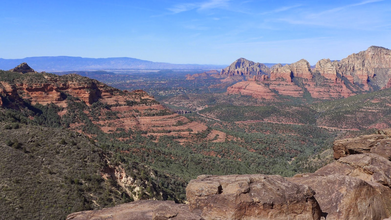
What draws me to the Hiline Trail is the view. Of all the trails I've ridden in Sedona, Hiline offers the most dramatic views of popular sites. When I rode Hiline with Alex, I think we rode most of it. Not today. There was nobody up there. A fall would have been disastrous.

I always seem to blank out the least desirable parts of rides when repeating them. The descent from Cathedral Rock not only confounds me, but the fact that people actually can ride it seems to defy physics.  You have to see riders cleaning it to believe it. While I was contemplating how to get down one section on foot without breaking both legs in a fall, a rider approached and stopped momentarily above me. I asked if he was going to ride it. He said yeah. I got out of the way. I thought for sure I'd be pulling out my phone to dial 9-1-1. But no, he cleaned it. Then he proceed to BOMB all the sections below that were just as nasty.

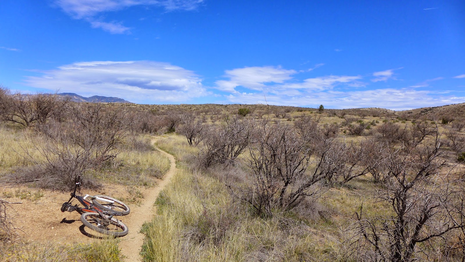
I crossed Oak Creek the same place I did in Thursday's ride. This time I was smahtah. I took my shoes and socks off to make sure wetness wouldn't attract red clay dust to form concrete in the cleats again. I finished up the loop by linking several trails that are "behind my hotel." Didn't see many people in this area, just west and south of the airport. The cool kids play in other areas now. I actually liked some of these trails, like Ridgeline. Tough climb, great view from the top, fast flowy descent.

I finished with 47.8mi in 5.3hrs riding time with 6000ft of climbing. That makes six days in a row riding significant new content, probably well over 100 miles of trails I've ridden for the first time. I've been to Tucson maybe 10 times now, and this was my fourth visit to Sedona. There are so many trails in both cities I haven't ridden yet, and new trails are being constructed every year.

After dark, Cathy and I headed out away from town to a trailhead. Spooky dark there, no moon in the sky, just stars. It was the first cloudless night of the trip. Sedona doesn't have much city lighting, so not much light pollution. The sky was pretty impressive, the first time Cathy saw the Milky Way. It wasn't quite as good that one time Dave and I drove back to Gunnison from Ouray though. That was much higher elevation and further away from any artificial lights.

Visiting Tucson and Sedona, Cathy and I talked about whether we could live in either city part-time. Instead of establishing a single homestead in Colorado in retirement, maybe do what my dad does. He has two modest places, a place on a lake in Michigan where he spends the summers and a place on the Texas gulf coast for winter. I do like Nordic skiing though, so not sure if I'd really want to spend the whole winter in a place where it is perfect riding conditions. Tough call. Have to think about this one some more.

Top of Schnebly Hill Rd at 6500ft

Grasslands above Sedona. Mingus Mtn in far distance, with Prescott on other side.

Snow-capped Humphrey's Peak at Flagstaff.

Sedona from Schnebly Vista.

Ledgy Schnebly Hill Road. I think I climbed this faster than folks in their Rav-4's.

Chapel Trail

Bench at beginning of Hiline Trail.

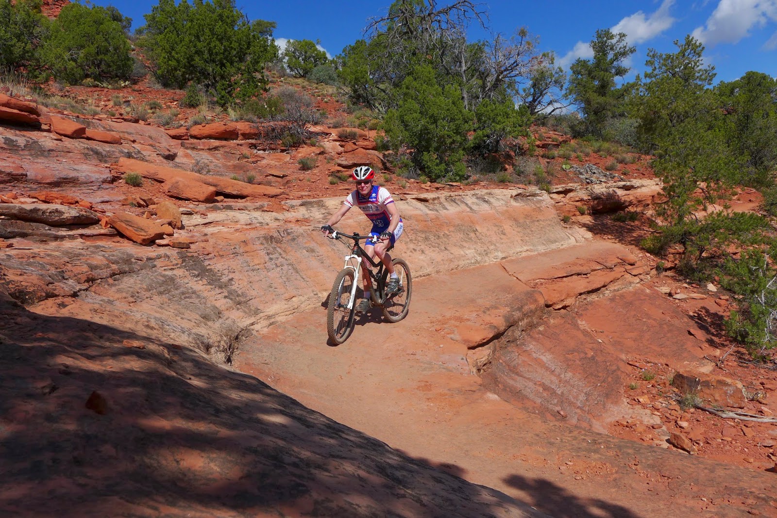
Only tame part of Hiline Trail. Tried five times to time this shot right and gave up. I was
either out of the frame or in the way of Courthouse Butte and Bell Rock or just
clipping in like this shot.

A fall over the edge would be disastrous. There is nothing to arrest your fall here.

Back side of Cathedral Rock. Can you see the trail as it slowly meanders down this massive
area of slick rock?

Love my Panasonic LX7. Here's a cropped, 100% pixel scale zoom of image above. Now
you can see the trail and a group of mountain bikers that I passed on my way down. There is
probably over a mile of slickrock trail shown in image above.

A snippet of Hiline descent. Grade was almost certainly greater than 100% (that means
steeper than 45 degree angle for those who got D's in geometry class). This is hands and feet
scrambling on foot. Note rubber skid marks.

On top of Ridgeline Trail near airport. Grand view of Courthouse Butte, Bell Rock and
Cathedral Rock.

Friday, March 28, 2014

Arizona Day 5 - Sedona BFL

When I planned this Arizona trip, I had hoped to ride most of the Black Canyon Trail in a day as a point-to-point shuttle. Wednesday's ride left me a bit shattered, and neither Cathy nor I relished the idea of spending a few hours in the car (Cathy was going to shop at the outlet mall at the trail terminus until I got there). And besides, why drive to a ride when staying in Sedona with so many great miles of singletrack right out the door?

I did piece together a big loop to ride in Sedona before leaving on the trip. It roughly followed the route of a annual informal race held each March, called the Sedona Big Friggin' Loop. When we drove into Sedona Tuesday evening, we stopped at Absolute Bikes to pick up an updated Sedona bike trails map. Fresh off the press, in fact, March 2014. It showed all of the newer stuff, such as Hiline, Hangover and all of the Hog trails. Little did I know, a chunk of my planned route did not show on the new map.

Chilly starting out early, only a windbreaker was needed, which soon came off. A mile from the hotel I was on dirt. It didn't take long before I realized this was going to be a different kind of ride than what I've done the first four days. I like trails that flow, where you can put steady power out if you want and get good return on climbing by being able to let speed run out. Today was not going to be one of those days.

Early morning sun, looking across to the Cockscomb (center right) and ledges
I would be riding on shortly (center left).

Soon I was riding on a skinny ledge. Hmm, I was saving exposure for later in the ride on Hiline Trail, but I was getting it just a couple miles in. The trail I was on does not exist on any map. Later I learned it is named as LF in Strava. Riding solo, I was uber cautious and walked some sections. A fall might not have been instant death, but it surely would have meant airlifted out in a few spots.

The Cockscomb

After I rode right under the Cockscomb, still "off the map," I started picking up named trails. The north side sequence I hit was Aerie, Mescal, Chuckwagon, Lizard Head, Thunder Mountain, Teacup, Jordan and bits of other trails.

Either Cockscomb or Aerie Trail

Much of this riding was quite technical, involving steep drops into washes and punchy climbs back out, often with big water bars to hop or natural ledge outcroppings. It didn't require huge cardio output, but it did require constant explosive power for a few seconds at a time, something my legs didn't have after four big days of riding.

Coffee Pot Rock on Teacup Trail

I must say I was glad to have my long travel 29er. I was rolling stuff I wouldn't think of rolling on my 26" dualie. The big bike doesn't make me a better rider though, and I'm not sure attempting bigger moves is a good thing.

Level, buff sections were fleeting instances on this ride. Chuckwagon Trail.

I had thought the first 30 miles of this loop would take less than 3hrs. I was very, very wrong. When I passed through town and stopped to top off my water, I called Cathy to let her know the ride was going to take two hours more than I planned. Tired legs, riding solo and cautiously, not having ridden these trails before, and constant stream of hikers and other bikers to yield for made for slow progress.

Even though the riding along the northern perimeter of Sedona tails didn't have the flow I'm accustomed to, there was some very sweet riding to be had. Particularly on Chuckwagon.

Riding rims on Chuckwagon Trail

After crossing through town, I picked up trails I've ridden before, but always in the opposite direction. Broken Arrow rides quite nicely from the Sedona end. Did have a few dabs on the way though. After wrapping around on Llama Trail, I was really feeling it and decided Hiline was not a good idea. You could die in a fall on that trail. I opted for Templeton instead, which wraps around the rim right below the famed Cathedral Rock.

Chicken Point (next to Twin Buttes) from Templeton Trail.

Cathedral Rock from Templeton. Pretty heavy overcast late in day. Temp probably didn't
get much above 60F. Perfect for me.

I've come up the Templeton switchbacks before. Hike-a-bike. I didn't fare much better going down them either. A couple guys were coming up that I had met on Teacup 1-2hrs earlier. Cathy didn't like the pictures I took riding this section.

Exposure approaching Templeton switchbacks

Cathy doesn't like seeing these

One of the riders I met earlier passing point where above two photos were taken. Don't look down!

I crossed over Oak Creek, which I was surprised to see flowing pretty good despite the serious drought the area has been in. Got my wheels cleaned and feet soaked. All I had left was to climb Herkenham Trail back to 89A, which I take a mile back to hotel.

Oak Creek crossing, Cathedral Rock in background. Wet feet and sticky cleats followed.

There were a few steep punchy bits on Herkenham that had me dabbing. I couldn't get my freaking feet out of the pedals! It appears that wet cleats pack up with red clay dust and form concrete when clipped in. In once case, I toppled over into dense brush and got my helmet caught. There I laid, clipped in, head stuck, unable to move. F-bombs!

Now I didn't dare clip in. I could not get the cleats to work freely. It took an inordinate amount of force to get a release.

Coming up the bank to pavement was another rocky incline, with rocks like daggers poking up everywhere. With fresh legs, it would be trivial to pop up this bank to the road. But I was damaged goods. So with something like 15 feet to go to finish the ride, how do you think this panned out? Of course I wrecked. Pretty much a backwards endo. Unable to get either foot out of the pedals, I came down hard on my ass and elbow. First thought was hip fracture, as you know, I have the bone density of a 70 year old woman. More F-bombs. I'm sure passing cars heard me if they had their windows down. 46 miles of rugged, risky terrain, and this is how I crash and get hurt?!

A couple hours and lots of Aleve later, I can barely walk or sit. Friday, my last full riding day, is going to be interesting. May have to settle for a Schnebly Hill dirt road climb.

Anyway, Cathy is enjoying herself while I ride. Wednesday she did a Pink Jeep tour out to Chicken Point and more. They made her scream a few times. Today she hiked part of the loop I rode, climbing up Little Sugarloaf, which is close to the hotel. The last two nights we ate at Thai Spices restaurant.  I eat a full entree with double steamed rice (family size serving bowl full) and then finish the second half of Cathy's entree. Have to roll me out of there afterwards, but very healthy preparations, tasty, and reasonably priced. Already dreading having to leave in a couple days.

Thursday, March 27, 2014

Prescott

I forgot to mention two stories from Tuesday. Shortly after I popped out on pavement at the bottom of Milagrosa, I heard a commotion in the desert to my right. An instant later, I'm knocked clear across the road trying to stay upright. Dust devil. Fortunately I was on a low traffic road and no cars where coming just then. The force very nearly slammed me to the pavement. Gravel the size of peas was flying through the air and hurt like hell. I was sweaty with sunscreen on. The dust devil left my looking like a powdered donut.

A couple hours later en route to Sedona, Cathy and I were heading into what looked like a thunderstorm. As we got closer, we realized the darkness was going up from the ground, not coming down from the sky. Uh-oh, that doesn't look good. It was wicked windy out. Just then a eardrum piercing screeching sound goes off in the car. We both about went through the roof. It was the emergency broadcasting system alarm tone. At first we thought the rental car did it, but no. It was my iPhone. Has that ever happened to anybody?

A message indicated a dust storm was brewing and to stay off the roads. Remember my drive over to Tucson Saturday night on I-10? I just can't win on that piece of highway. Traffic slowed to a crawl and the sun blackened out. I've never experienced a full-fledged dust storm before. Visibility was akin to blizzard conditions in Michigan. Just nuts. Tumbleweeds as big as small cars were aloft high in the sky. Other debris was blowing across the highway too. Eventually we drove through it, and just like a light switch, we went from dark brown sky to crystal clear blue sky.

It was even windier on Wednesday for my big ride in Prescott. No open farmland or flats around here, so the dust wasn't too bad. Just had to dodge tumble weeds on Rt 89 coming back from Prescott to Sedona.

I pulled a bunch of Strava tracks from guys and gals that do long rides in Prescott. I searched for 30 and 40+ mile loops. You tend to get more quality tracks that way, folks serious about doing long rides. I loaded the tracks into DeLorme Topo so I could see where there was the most overlap and which direction most people rode sections. From this, I cut and spliced GPX segments together to make a 40+ mile loop with some serious climbing.

It is a lot colder here than in Tucson. Prescott sits about a mile high. Driving over Mingus Mountain, the temp display in car dropped to 44F. And it was wicked windy. I did not throw any long layers in the car. Plus, I planned to climb even higher than the Rt 89A pass. I was just going to have to ride harder to stay warm.

I parked downtown. There was five miles of urban jungle before I hit the first singletrack. The trail was good, heading out towards Lynx Lake. Well maintained, nice flow, not too rocky nor too easy. I needed that after being punished on Milagrosa the day before.

Then the climbing started on Smith Ravine trail heading up Spruce Mtn. Doable, but why was I breathing so hard? Oh yeah, I'm at 6500ft. When you spend 99% of your life below 500ft, 6500ft feels like you're taking another 30 pounds up the mountain with you.

Then the grade got not only steeper, but loose. I had to drop tire pressure to keep from flinging large rocks out from under my rear tire. It seemed every time I looked at the GPS, it said 15% grade or higher. Sometimes over 20%. That was good for tired legs.

I managed to reach the fire tower up top without having to put on my light wind shell. I had the mountain to myself if seemed. Nice view from a rocky outcropping there.

The Prescott Valley from Spruce Mtn summit. Dusty haze in the air.

Peering over into the abyss. Was shivering by the time I headed down.

From the summit, I headed south along a ridgeline. It rolled some, losing just a little vertical. The surface was mostly chunder. As the trail dropped off the ridgeline, it became all chunder. Some readers may ask, what exactly is chunder? It is this.

Steep as heck and tires wanted nothing to do with staying under you.

It's nice to get a return on your vertical investment. But the initial descent was almost as painfully slow as the climb. When I reached the lower flanks, the trail cleaned up nicely. Despite the chunder, extensive maintenance was evident. It's just what the terrain consists of on Spruce Mtn.

Connecting over to Wolverton Mtn was some sweet, buffed out contouring material, Trail 396. You could really haul on it if you wanted. Sections were as smooth and hard as pavement. The Wolverton Trail was a much more manageable grade for tired legs. It appeared to meander through an area that may have burned many years ago, as there were no mature ponderosa pines there.

Wolverton on outskirts of town

Higher up on Wolverton

The initial plummet off Wolverton was doubletrack. Nice return on climbing investment here. Just had be careful to not overcook a turn. The descending continued on mint singletrack. I reached my connection back into town and was bummed. The singletrack continued, and I did't really want to "waste" the remaining vertical on gravel and paved roads back into town. But I was cooked and needed to get back to Sedona.

SPF-50 and still getting burned

I finished with 43.5mi in 4.9hrs riding time and 6600ft vertical on the Garmin. The wheel sensor died, so distance is short. Due to the punchy nature of climbing in this loop, I was pretty thoroughly destroyed. Have to reassess what to do on Thursday now. This ride was a tiny sampling of what is available in Prescott. I suspect there are as many miles of singletrack around Prescott as there are around Durango. I'd love to spend more time riding here on another trip.

Wednesday, March 26, 2014

La Milagrosa

A trail on Tucson's east side I've always had a morbid curiosity to check out is La Milagrosa, or The Miracle. It starts high above the city and descends initially on a ridge line, then later along the lip of Milagrosa Canyon. I've seen the photos and GoPro videos. I had no business riding it. But it can be used to close a nice loop and I felt compelled to at least check out a Tucson riding reference standard.

The day's loop started out up dirt Reddington Rd. About 15 miles in and 1700ft up, the Arizona Trail is picked up near where it comes out of the Rincon Wilderness. I rode this once before with Dave, and I remembered it as buff. Parts were not - pretty chunky, with punchy climbing sections. Guess I remembered only the easy parts.  The AZT crosses over Reddington Rd much further in and climbs some more. There were periodic skill checks along the way, and I failed several of the tests. Great riding though. It was cooler up there, and the trail had a seriously remote vibe to it. No body around and miles from town.  It seemed this section of the AZT doesn't get ridden much.

After many miles of contouring trail (term used loosely, frequent VOmax efforts were required), I got to the Milagrosa trail junction. After not seeing a soul for 2+ hours, a backpacker headed down Milagrosa just as I got there. I took a break to eat. The hiker told me to give a good yell out when I caught up to him. His hearing was that good anymore.

The trail started innocuous enough. A couple dismounts here and there. Then I caught the hiker on a section that forced a dismount. He commented "this is really nice here, wait until you get a little further down." Hmmm, I thought I was already getting into trouble.

Then I hit the section referred to a "The Gauntlet." Yeah. Guys (and gals) actually ride this? I was pretty sure I was going to break a leg hike-a-biking down it. My progression was more like a semi-controlled slide down loose rocks. It took a good while to get past that section.

There was more somewhat leveled off ridge riding with amazing views into canyons on either side of the trail. No fear of death stuff, just brutally rugged terrain. This was clearly a hiking trail that hard core riders test their mettle on. In between frequent dismounts, I managed to scare myself good on sections I went for. I even dropped my seat, a foreign concept to Hill Junky. Whacked, riding this alone.

I made it to the bottom with no crashes but several oh-f's! A couple miles of pavement closed the loop. I was surprised to finish the 36mi, 4hr ride with close to 9mph avg. Milagrosa took me an hour, something like 3mph average down hill! I can check that one of my list and not have to do it again.

Relatively short riding day. Headed up to Sedona in the afternoon. Looking forward to hitting more new terrain in and nearby Sedona over the rest of the week.

Looking down Reddington Rd with Tucson in distance

AZT grasslands at around 4500ft

A hotter, more deserty looking part of the AZT

AZT heading toward Milagrosa. Cathy was checking out the sights in the Santa
Catalinas in the distance.

More AZT contour

La Milagrosa Trail

A snippet of "The Gauntlet." Way steeper than it looks. Folks ride this stuff.

I think this is Agua Caliente Canyon

Riding along lip of La Milagrosa Canyon

Many sections of extremely steep granite

Tuesday, March 25, 2014

Tortolitas, Baby!

Hit a new riding destination today, the Tortolita Mountains northwest of Tucson. The trail network has been growing steadily for over 10 years now. Some of the new trails are getting rave reviews. Even though many of the trails in the Tortolitas are extremely technical, it was time I checked this area out.

I had a modest 34mi loop planned. I didn't want to go bigger than this, fearing even 34mi could go over four hours moving time. I also avoided some of the trails whose Strava segments have typical average speeds of 4-5mph. These are trails that guys and gals like to hone their skills on. The only thing I would hone would be my bones against the rocks.

A new trail that is just about done is the Ridgeline Trail. There is an unofficial connection that lets riders integrate this trail into a loop high in the Tortolitas. Ridgeline is so new, I couldn't find much info on it. Would I be hike-a-biking most of it? Was there fear of death exposure? The scenery was sure to please.

I started out on a trail called Como. It starts as jeep track and eventually narrows down to tight, moderately technical singletrack, fairly steep at times. It was warm out. I was sweating before the climbing even got down to business.

After cresting a pass and dropping a ways on the other side, another jeep track is taken, called Edwin Rd I think. It became a serious grind near the top, about 1300ft net gain from where I parked. After bombing down the other side, some newer singletrack is picked up, Wild Burro Trail. This was very tightly constructed through often rugged terrain. You couldn't be looking around riding this trail. A few minutes in, an object in the trail triggered my moving target indicator. It was a Gila Monster! Fortunately he was crawling away from me and didn't know I was there, so I had time to get the camera out. Quite pretty and quite creepy looking. It was almost as big as my forearm.

After dropping down and crossing the wash, the new Ridgeline Trail is taken to form a height-of-the-land loop. Ridgeline was a pretty serious grunt to start, with many steep switchbacks. I was impressed with the workmanship. Was this trail machine built, I wondered? So much benching and armoring in brutally rugged terrain.  There was near continuous moderate exposure. No instant death if you screw up stuff, but potentially not getting back out on your own in a few places. Great views of Tucson and the Catalinas opened up in several places.

Once reaching the high point, the trail contoured through amazing scenery. Whoever laid the trail out was a genius to see a line through that terrain. It flowed sweetly. Coming around to the part I wondered was finished, I saw fresh shovel marks with no bike tracks over them. The trail crew was out. I got to thank the guys in person for the fine work they were doing. The tortolitas were quickly moving up my list of top rides in Arizona.

Taking an interim route back down to the wash, I had to climb back over the Edwin Rd pass again. This side seemed even steeper and it was hotter out. But I knew from the summit, it was 15 miles near monotonic downhill back to the car.

A different route than Como was taken. Don't know the name of the trail, but it was miles and miles of interstate-buff singletrack. And the whole time you're staring at the Santa Catalina Mountains. That's the way all long rides should end. A couple miles of pavement closed the loop back to my car. The 34mi, 3.5hr ride went smoother than I thought. I checked with Cathy to see if she had more things to do. I wanted to hit Fantasy Island on the east side of town closer to our hotel.

Fantasy Island is a 20+ mile amusement park for mountain bikes. Gravity cavities, high-speed berms, table-tops and many air opportunities, and all-out speed sections galore. Fantasy Island has the highest fun-factor to energy expenditure ratio of any place I ride. There is very little elevation change there. I figured I was digging a deep whole early in the trip, but I had to hit it.

As best I can tell, I hit everything, and then some, in 24mi/2hrs riding time.That made 58.6mi of trail riding for the day. Not a huge amount of climbing though. That will come later.

Heading up to the Edwin Rd pass

Gila Monster on Wild Burro Trail


Wild Burro Trail


More Wild Burro Trail

Sprawling Tucson metropolis in distance from Ridgeline Trail


Looking down Edwin Rd towards the Catalinas

Mt Lemmon

Finishing singletrack

"Bunny Trail" at Fantasy Island with the Ricons in the background