Several people have notified me that my Northeastcycling.com website is down. Lycos provides the hosting and domain name registration service. I am working with them to get it restored. Lycos lost control of my domain name and has requested I contact a third party to regain control of it. Of course, that third party is requesting money. Basically my domain name is being held hostage. I don't know how Lycos let this happen. I suspect it may involve others whose domain names were registered through this third party foreign registrar company. I'm still working to get it back but won't pay extortion fees to do so. Don't know where this will end up yet. I invest little time in Northeastcycling these days and certainly don't have time to reconstruct the entire site with another host. Any suggestions for painless transition are welcome.
One reader pointed out an archiving site has a fairly recent archive of my site. It appears to all be there. You will find it at Way Back Machine.
Tuesday, May 31, 2016
Sunday, May 29, 2016
Wa-Wa What?
Back in 2012, I made the lottery selection for the Mt Washington foot race. I dabbled in running, mainly to combat low bone density, which I was diagnosed with two years earlier. I ran up to an hour once a week and did some repeats on nearby Mt Pack Monadnock several times. Then a week before the 2012 Mt Washington race, I injured my calf. Out just like that. I pretty much said eff this running business.
I kept entering the Mt Washington lottery, as I've always wanted to see what I can do on foot relative to my many bicycle times. Finally in 2016, I got in again. I pretty much stopped running when I started hiking last summer. I have to think 5-10 hour hikes will do more for bone health than 25 minute lunch runs once or twice a week.But can it prep you for something as grueling as running up Mt Washington?
Hiking has brought about positive adaptations. My dorsilflexion has improved. My achilles and calves are considerably stronger. I think risk of calf injury is very low now.
I started running repeats on Pack Monadnock again. I haven't done much focused VOmax work the last couple years. Running up a mountain is a sure way to get your hurt on! Going down was a problem in 2012. I would get excruciating shin splints and DOMS a couple days later. I found all the descending in hiking made me DOMS proof now. I also noticed the increased dorsilflexion changed my uphill running technique. On Pack, there are sections on the paved road to the summit that are 15-20% grade. Before, I could not heel plant. I'd end up running on the balls of my feet on the steepest parts, which was extremely stressful on my calves, and it also felt like I couldn't engage my hamstrings fully.
Three weeks out from the Mt Washington race, I signed up for the Mt Wachusett 10k race with great hesitation. The course goes up and over the summit, all the way back down. I suck at downhill running, or downhill anything for that matter. But I wanted some pacing experience in a race situation before Mt Washington. I could always walk/run the descent.
Wouldn't you know it, the temp was expected to rise well into the 90's on Saturday for the race. I tolerate heat more poorly than most. The race wasn't that early either, starting at 9:30am. The skies cleared and the sun turned the mountain into an oven as 300+ racers lined up for a mass start.
We go off and I find myself about 50 runners back. The grade kicks up on Mile Hill Rd, the breathing around me gets louder. I started reeling people in. I maybe gained 10-15 spots by the time we turned into the state park. After a brief downhill, the climbing resumes. We turn left onto the one-way "down" road, which is uber steep. Are we hurting yet? The discomfort level went beyond anything I experienced on my Pack training repeats. I felt like a liter a minute was dripping off my hands and elbows.
A right turn onto the summit spur had us face-to-face with 15% grade in full sun. I just wanted to hit that mat up top, get my summit split and stop. The heat was giving me abdominal cramps. My thermal governor had kicked in, and it took only 23 minutes. I crossed the mat, ran around the tower, and headed down. Why was I still running?
The 15% grade heading down didn't freak me out like I thought it would. There was some braking going on, but not jack-hammer kind of stuff. I still felt somewhat fluid. The least steep parts I kind of ran wide open without pushing it. Maybe I keep this race going for bit to see how this descent business works. My biggest concern was my knees giving me the big f-you, but there was no hint of that.
Half way down, the course veers left onto gravel fire road. The surface was pretty predictable, there were areas of loose ankle biter rocks. Again, I think the hiking over the past 10 months gave me the confidence and stability in my ankles to maintain a decent pace. It's amazing how hard you can still breath running downhill. I was surprised only one person passed me on the 3.2mi descent.
I finished in 45:33, good for 18th/311 finishers overall, about what I thought was possible. I was pretty happy with that, especially given the oppressive heat. My hamstrings were in a bit of a funk after I finished, but my knees were fine. I guess sometimes you just have to step outside of your comfort box if you want to learn new things about yourself. I'm not about to take up trail running though, at least not downhill.

There's really no good way to extrapolate this result to how I might do on the big Rock Pile in three weeks. I do have a goal, and that is to gain the 4700ft in less than 80 minutes. Hopefully we don't get a scorcher like Saturday. I'd DNF running that long in heat. I do plan to run a couple of the other mountain climbs, like Loon and the Whiteface Vertical K in NY. Off road, and the finish is at the top for these events!
I kept entering the Mt Washington lottery, as I've always wanted to see what I can do on foot relative to my many bicycle times. Finally in 2016, I got in again. I pretty much stopped running when I started hiking last summer. I have to think 5-10 hour hikes will do more for bone health than 25 minute lunch runs once or twice a week.But can it prep you for something as grueling as running up Mt Washington?
Hiking has brought about positive adaptations. My dorsilflexion has improved. My achilles and calves are considerably stronger. I think risk of calf injury is very low now.
I started running repeats on Pack Monadnock again. I haven't done much focused VOmax work the last couple years. Running up a mountain is a sure way to get your hurt on! Going down was a problem in 2012. I would get excruciating shin splints and DOMS a couple days later. I found all the descending in hiking made me DOMS proof now. I also noticed the increased dorsilflexion changed my uphill running technique. On Pack, there are sections on the paved road to the summit that are 15-20% grade. Before, I could not heel plant. I'd end up running on the balls of my feet on the steepest parts, which was extremely stressful on my calves, and it also felt like I couldn't engage my hamstrings fully.
Three weeks out from the Mt Washington race, I signed up for the Mt Wachusett 10k race with great hesitation. The course goes up and over the summit, all the way back down. I suck at downhill running, or downhill anything for that matter. But I wanted some pacing experience in a race situation before Mt Washington. I could always walk/run the descent.
Wouldn't you know it, the temp was expected to rise well into the 90's on Saturday for the race. I tolerate heat more poorly than most. The race wasn't that early either, starting at 9:30am. The skies cleared and the sun turned the mountain into an oven as 300+ racers lined up for a mass start.
We go off and I find myself about 50 runners back. The grade kicks up on Mile Hill Rd, the breathing around me gets louder. I started reeling people in. I maybe gained 10-15 spots by the time we turned into the state park. After a brief downhill, the climbing resumes. We turn left onto the one-way "down" road, which is uber steep. Are we hurting yet? The discomfort level went beyond anything I experienced on my Pack training repeats. I felt like a liter a minute was dripping off my hands and elbows.
A right turn onto the summit spur had us face-to-face with 15% grade in full sun. I just wanted to hit that mat up top, get my summit split and stop. The heat was giving me abdominal cramps. My thermal governor had kicked in, and it took only 23 minutes. I crossed the mat, ran around the tower, and headed down. Why was I still running?
The 15% grade heading down didn't freak me out like I thought it would. There was some braking going on, but not jack-hammer kind of stuff. I still felt somewhat fluid. The least steep parts I kind of ran wide open without pushing it. Maybe I keep this race going for bit to see how this descent business works. My biggest concern was my knees giving me the big f-you, but there was no hint of that.
Half way down, the course veers left onto gravel fire road. The surface was pretty predictable, there were areas of loose ankle biter rocks. Again, I think the hiking over the past 10 months gave me the confidence and stability in my ankles to maintain a decent pace. It's amazing how hard you can still breath running downhill. I was surprised only one person passed me on the 3.2mi descent.
I finished in 45:33, good for 18th/311 finishers overall, about what I thought was possible. I was pretty happy with that, especially given the oppressive heat. My hamstrings were in a bit of a funk after I finished, but my knees were fine. I guess sometimes you just have to step outside of your comfort box if you want to learn new things about yourself. I'm not about to take up trail running though, at least not downhill.

Gaunt from dehydration and rocking the goofy cyclist's tan
There's really no good way to extrapolate this result to how I might do on the big Rock Pile in three weeks. I do have a goal, and that is to gain the 4700ft in less than 80 minutes. Hopefully we don't get a scorcher like Saturday. I'd DNF running that long in heat. I do plan to run a couple of the other mountain climbs, like Loon and the Whiteface Vertical K in NY. Off road, and the finish is at the top for these events!
Friday, May 27, 2016
GPS Frustrations
Most engineers obsess over measurement accuracy. In my line of work as a research engineer, we often push against the limits of what's doable. Sometimes independent verification of our results is required. It should not be surprising then, if some of this rubs off into tracking recreational pursuits.
I used a Garmin Edge 705 GPS unit for many years. I loved that unit. It produced impeccably accurate tracks in even adverse conditions. Well sealed, the unit was not. After one too many deluges in Colorado, the 705 gave up the ghost.
I transitioned to a Garmin 510, which added Russian GLONASS reception to the US-based GPS constellation. I was pleased with the 510's track accuracy too, perhaps comparable to the 705. Under tree cover or heavy overcast, the 510 consistently produced smooth, tight tracks exactly where I went.
Garmin does have a reputation, though, and not all good. They are notorious for releasing buggy products to the market. Basically, they make consumers like me their beta test group even though we did not agree to provide this service. Software updates often come fast and furious for newly released Garmin products.
Some bugs (or maybe Garmin thinks they're features?) never seem to get fixed. I have a major peeve with my 510. It does everything I want it to for cycling, the activity the unit was designed for. But I also use the 510 for running, hiking and Nordic skiing. During hiking, I've notice very large variation in my recorded distances, even for same hikes. One time I'll log 9mi, another time 11mi for exactly the same route. What gives?
I learned to turn off auto-pause when hiking. Sometimes you go so slow in technical sections that the unit will pause and stop logging data. However, upon probing into suspect track files, I noticed something peculiar. The 510 appears to stop distance tagging when speed drops below a certain value, say 2mph, but it continues logging lat/lon coordinates, barometric altimeter and time stamps. Only distance tag stays stuck. It appears turning off auto-pause only partially turns it off. The result is the distance tally displayed ends up way short for most hikes. Further, when posting to websites like Strava, Strava blindly follows the distance tagging and reports incorrect distance - most of the time. I've had a few instances where GPS distance was so short that Strava recognized a discrepancy, threw out the distance tagging, and recalculated actual distance from lat/lon coordinates.
So then I got smart and found a way to strip distance tags from my 510 hiking track files before posting to Strava, forcing Strava to compute distance from raw data. But this also stripped barometric altimeter data, which is far more accurate when hiking rugged terrain than what can be calculated from a digital elevation map that uses 30 meter or 100 meter grid. This situation sucked! I could either get accurate climbing or accurate distance, but never both!
Faced with this frustration, I decided to buy a running/hiking specific GPS. I picked up the recently introduced Suunto Traverse. It comes with barometric altimeter and tracks both GPS and GLONASS satellites. This sounded really good, although reviews were pretty negative on battery life. Suunto has a much better reputation for releasing new products with few bugs, unlike Garmin.

My first test of the Suunto Traverse was on Mt Pack Monadnock, running repeats on the autoroad to the summit. I liked the less bulk on my wrist. The user interface is vastly different from Garmin and requires a learning curve. I couldn't wait to get home to see the results, of both GPS performance and my performance. I expected to have run a PR lap, and Strava was going to tell me this after uploading to their site.

When I first saw the track, I thought this can't be right. It is so awful there must have been an error uploading. But no. I looked at it multiple ways. Track accuracy sucked donkey balls! Because of such poor positional accuracy, the climbing segment I was tracking my performance on was either missed completely or didn't start/stop in the right places. None of the three repeats I did had useful data. And I buried myself on the second one to see where my fitness was at! The Suunto didn't nuisance auto-pause on me though. Fix one problem, end up with an even bigger one.
So what should this track look like? Image below is from my Garmin 510 on the same course. It is almost perfect. Segments started and stopped where they were supposed to.

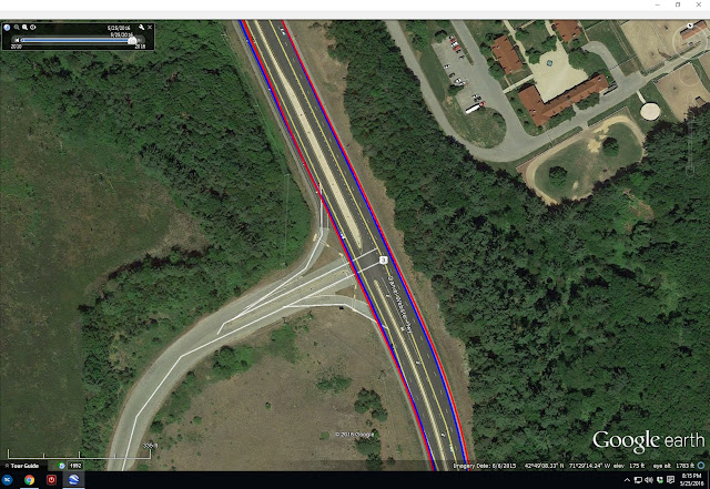
So maybe this was an anomaly. If a GPS gets a bad initial fix, it's accuracy can be FUBAR for the entire use cycle. So I gave it another chance on a lunch ride, off-road in the woods. This time I ran both my 510 and the Traverse. The results were revealing. This first image shows start and finish of my ride at the office. Blue is the Garmin 510, red the Suunto Traverse. I started both units at my car, and the fixes are within 5ft of each other. I was rolling when I stopped the two units coming back, so the 6 car spots difference is real.

This next photo shows open road tracking heading out and returning from my woods ride. Tracks are literally on top of each other and on the shoulder of the road exactly as I rode. So far, so good.
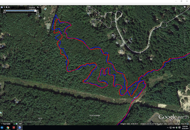
In the woods is where things got interesting. This first is a trail called Pipeline, which is mostly canopied in hardwoods. The leaves were just starting to bud out. Note there are many discrepancy areas. I've ridden this trail many, many times and can attest to the accuracy of the blue Garmin track, especially in upper left area of image. The trail comes out along a fence line. The red Suunto track comes up way short. Many other wiggles in the blue that are real, mysteriously get straight-lined out in the red Suunto. Why?
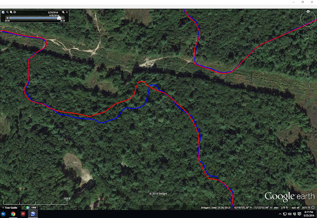
Here's another woods comparison. This is the Loop Trail in Horse Hill Preserve. Again, error on order of 100ft and smoothed out ripples.
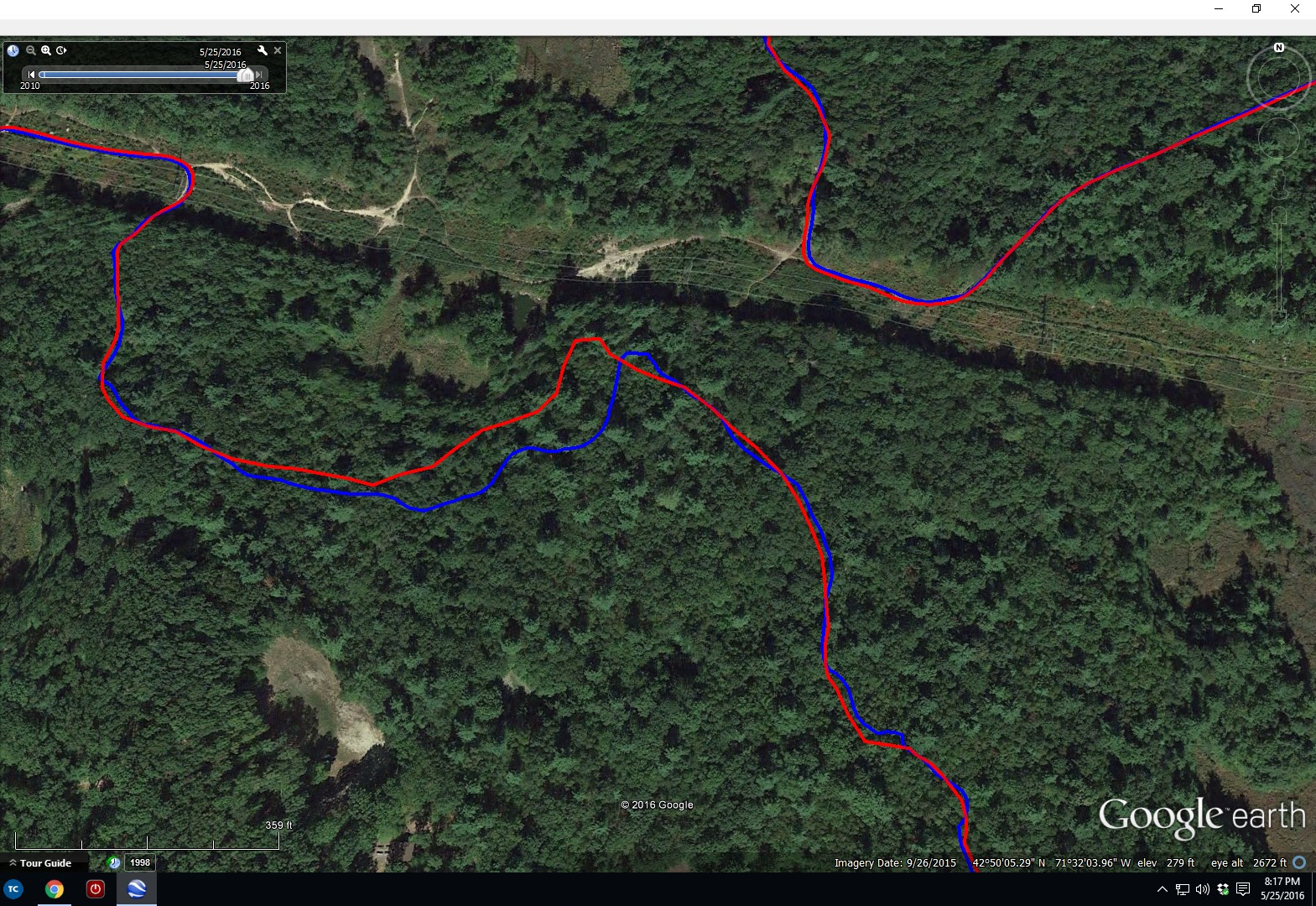
And a final woods difference. Notice the S-curve near the tip of the lake on Duster Trail. It is accurately recorded by the blue Garmin track but missed completely by the red Suunto trace. The discrepancy grows very large later in the track as I traveled toward the upper right of the image. I had recording interval set to 1sec on the Suunto, the max rate. This is not at all what I expect from an expensive, latest generation GPS technology device.

As a radio-frequency engineer, I understand trees can attenuate GPS signals. I've always been selective on buying GPS units with high sensitivity, units with a lot of performance margin so they work well in less than ideal conditions. Antennas are an extremely important part of a GPS receiver. When you have a unit the size of the Garmin 510, or especially the 705 I used to have, you have some area to work in to make a decent antenna. These plots suggest the Suunto Traverse has marginal sensitivity. Get under trees where the signal becomes weaker, performance goes to crap. It was perfect on the road.
After poking around on Suunto sensitivity, I made some discoveries. The predecessor to the Traverse, the Suunto Ambit3, used an external nub to house the antenna. It protruded into the wrist band area. Apparently consumers thought this looked stupid. So Suunto moved the antenna into the bezel of the unit and TRASHED the receiver sensitivity. I'm an engineer. I want performance, not something that looks pretty and doesn't fucking work! I guess you could say consumers did it to themselves on this one. If you research this, you will find that Garmin wrist-watch products suffer similar poor performance.
This shouldn't be difficult to get right. If Garmin products weren't so buggy, I'd be happy continuing to wear the bulky 510 on my wrist. It offers so many benefits over a watch-sized unit anyway, like useful screen size for navigation. I could move away from wrist unit altogether. This would likely get me the sensitivity I desire for accurate tracks. There'd be more product lines to chose from, maybe some less buggy. But where do you put it, say when you are running? XC skiing? The wrist is really convenient. The Traverse is going back. I may exchange it for a Suunto Ambit3. Track files for this unit look pretty clean, and the Ambit doesn't even use the Russian GLONASS constellation. Much longer battery life too. Maybe there is no such thing as a perfect GPS unit out there. Or maybe I'm just too picky...
I used a Garmin Edge 705 GPS unit for many years. I loved that unit. It produced impeccably accurate tracks in even adverse conditions. Well sealed, the unit was not. After one too many deluges in Colorado, the 705 gave up the ghost.
I transitioned to a Garmin 510, which added Russian GLONASS reception to the US-based GPS constellation. I was pleased with the 510's track accuracy too, perhaps comparable to the 705. Under tree cover or heavy overcast, the 510 consistently produced smooth, tight tracks exactly where I went.
Garmin does have a reputation, though, and not all good. They are notorious for releasing buggy products to the market. Basically, they make consumers like me their beta test group even though we did not agree to provide this service. Software updates often come fast and furious for newly released Garmin products.
Some bugs (or maybe Garmin thinks they're features?) never seem to get fixed. I have a major peeve with my 510. It does everything I want it to for cycling, the activity the unit was designed for. But I also use the 510 for running, hiking and Nordic skiing. During hiking, I've notice very large variation in my recorded distances, even for same hikes. One time I'll log 9mi, another time 11mi for exactly the same route. What gives?
I learned to turn off auto-pause when hiking. Sometimes you go so slow in technical sections that the unit will pause and stop logging data. However, upon probing into suspect track files, I noticed something peculiar. The 510 appears to stop distance tagging when speed drops below a certain value, say 2mph, but it continues logging lat/lon coordinates, barometric altimeter and time stamps. Only distance tag stays stuck. It appears turning off auto-pause only partially turns it off. The result is the distance tally displayed ends up way short for most hikes. Further, when posting to websites like Strava, Strava blindly follows the distance tagging and reports incorrect distance - most of the time. I've had a few instances where GPS distance was so short that Strava recognized a discrepancy, threw out the distance tagging, and recalculated actual distance from lat/lon coordinates.
So then I got smart and found a way to strip distance tags from my 510 hiking track files before posting to Strava, forcing Strava to compute distance from raw data. But this also stripped barometric altimeter data, which is far more accurate when hiking rugged terrain than what can be calculated from a digital elevation map that uses 30 meter or 100 meter grid. This situation sucked! I could either get accurate climbing or accurate distance, but never both!
Faced with this frustration, I decided to buy a running/hiking specific GPS. I picked up the recently introduced Suunto Traverse. It comes with barometric altimeter and tracks both GPS and GLONASS satellites. This sounded really good, although reviews were pretty negative on battery life. Suunto has a much better reputation for releasing new products with few bugs, unlike Garmin.

Suunto Traverse vs Garmin 510 on the wrist
My first test of the Suunto Traverse was on Mt Pack Monadnock, running repeats on the autoroad to the summit. I liked the less bulk on my wrist. The user interface is vastly different from Garmin and requires a learning curve. I couldn't wait to get home to see the results, of both GPS performance and my performance. I expected to have run a PR lap, and Strava was going to tell me this after uploading to their site.

First Suunto Traverse track. Only lap missed summit by hundreds of feet.
When I first saw the track, I thought this can't be right. It is so awful there must have been an error uploading. But no. I looked at it multiple ways. Track accuracy sucked donkey balls! Because of such poor positional accuracy, the climbing segment I was tracking my performance on was either missed completely or didn't start/stop in the right places. None of the three repeats I did had useful data. And I buried myself on the second one to see where my fitness was at! The Suunto didn't nuisance auto-pause on me though. Fix one problem, end up with an even bigger one.
So what should this track look like? Image below is from my Garmin 510 on the same course. It is almost perfect. Segments started and stopped where they were supposed to.

So maybe this was an anomaly. If a GPS gets a bad initial fix, it's accuracy can be FUBAR for the entire use cycle. So I gave it another chance on a lunch ride, off-road in the woods. This time I ran both my 510 and the Traverse. The results were revealing. This first image shows start and finish of my ride at the office. Blue is the Garmin 510, red the Suunto Traverse. I started both units at my car, and the fixes are within 5ft of each other. I was rolling when I stopped the two units coming back, so the 6 car spots difference is real.

This next photo shows open road tracking heading out and returning from my woods ride. Tracks are literally on top of each other and on the shoulder of the road exactly as I rode. So far, so good.

In the woods is where things got interesting. This first is a trail called Pipeline, which is mostly canopied in hardwoods. The leaves were just starting to bud out. Note there are many discrepancy areas. I've ridden this trail many, many times and can attest to the accuracy of the blue Garmin track, especially in upper left area of image. The trail comes out along a fence line. The red Suunto track comes up way short. Many other wiggles in the blue that are real, mysteriously get straight-lined out in the red Suunto. Why?

Here's another woods comparison. This is the Loop Trail in Horse Hill Preserve. Again, error on order of 100ft and smoothed out ripples.
And a final woods difference. Notice the S-curve near the tip of the lake on Duster Trail. It is accurately recorded by the blue Garmin track but missed completely by the red Suunto trace. The discrepancy grows very large later in the track as I traveled toward the upper right of the image. I had recording interval set to 1sec on the Suunto, the max rate. This is not at all what I expect from an expensive, latest generation GPS technology device.

As a radio-frequency engineer, I understand trees can attenuate GPS signals. I've always been selective on buying GPS units with high sensitivity, units with a lot of performance margin so they work well in less than ideal conditions. Antennas are an extremely important part of a GPS receiver. When you have a unit the size of the Garmin 510, or especially the 705 I used to have, you have some area to work in to make a decent antenna. These plots suggest the Suunto Traverse has marginal sensitivity. Get under trees where the signal becomes weaker, performance goes to crap. It was perfect on the road.
After poking around on Suunto sensitivity, I made some discoveries. The predecessor to the Traverse, the Suunto Ambit3, used an external nub to house the antenna. It protruded into the wrist band area. Apparently consumers thought this looked stupid. So Suunto moved the antenna into the bezel of the unit and TRASHED the receiver sensitivity. I'm an engineer. I want performance, not something that looks pretty and doesn't fucking work! I guess you could say consumers did it to themselves on this one. If you research this, you will find that Garmin wrist-watch products suffer similar poor performance.
This shouldn't be difficult to get right. If Garmin products weren't so buggy, I'd be happy continuing to wear the bulky 510 on my wrist. It offers so many benefits over a watch-sized unit anyway, like useful screen size for navigation. I could move away from wrist unit altogether. This would likely get me the sensitivity I desire for accurate tracks. There'd be more product lines to chose from, maybe some less buggy. But where do you put it, say when you are running? XC skiing? The wrist is really convenient. The Traverse is going back. I may exchange it for a Suunto Ambit3. Track files for this unit look pretty clean, and the Ambit doesn't even use the Russian GLONASS constellation. Much longer battery life too. Maybe there is no such thing as a perfect GPS unit out there. Or maybe I'm just too picky...
Wednesday, May 25, 2016
Bear Standoff in the NEK
I made the first pilgrimage of 2016 up to the Northeast Kingdom of Vermont on my off-Friday with Connecticut riding buddies Alex and Jason. Like the mountains I've been hiking in, not all of the Kingdom Trails have dried out yet. Some of my favorite trails on Burke Mountain are still closed. All of the Darling Hill trails were open though, and there are many miles of great riding outside of the NEK trails network.
One feature I've hit many times is East Mountain, aka "Radar Mtn." East Mountain is the site of an abandoned cold war era military radar installation. It is in a remote area, not easily seen from most valleys where people live. A timber company now owns most of the woodland around the installation, with a private owner owning the buildings.
With Burke Mountain singletrack being closed, the three of us thought a big loop out to Radar Mtn would help fill out a big ride in the Kingdom. We'd roughly follow the Rasputitsa course in reverse out to Radar Mtn in East Haven. For about 10 years, I've wanted to ride through Victory Basin on the back side of Burke Mtn. It's all dirt roads, some narrow seasonal roads. None of us have any aversions to riding mountain bikes on roads. They work just fine, unlike road bikes on a trail.
A sporty pace quickly developed on the first climb up Kirby Mountain Rd. I didn't exactly taper for a race for this ride but started wondering if I should have. The descent to River Rd was sweet. The open views in the basin were gorgeous. We might have seen one or two cars looping around Burke Mtn on this Friday morning.


We reach Gallup Mills and the entrance to Radar Rd in no time. The lower gate was open. I was surprised to find the road vastly improved. It had been a few years since the last time I rode up Radar Mtn. Then it was a doubletrack. Now it was a full width improved gravel road. The climbing along the brook was very gradual.
Less than a mile in, we spooked a black bear in the road. Looked like a young one, probably two years old. He bolted into the woods quickly. I was just thinking earlier that I hadn't seen a bear in quite a while, especially with all of the hiking I've done since last summer. True, bears hibernate, but they've been active for a while now this spring.
At the T-junction in Radar Rd, we found the next gate heading up to also be open. I hadn't seen that before. The road here too was improved to the point where ordinary cars could go up. Why all this improvement? This section used to be eroded, rutted out jeep track. I knew one thing for sure, the descent was going to be so much nicer.
Upon reaching the barracks area, one car was parked. Spooky there, many old buildings that haven't been used in over half a century. We then encountered the new barrier I read about. A massive tank bolstered by huge rocks was placed across the road where it is swamp on either side. Yeah, that will quite effectively prevent car loads of partiers from going the last two miles up the mountain. Vandalism and destruction of property has been a problem, and the private owner had enough of it. Passive recreational use is still permitted. I hope we don't lose it.

It was a bit of a hassle to carry bikes around the barrier, but we were into the final 20 minute push to the summit. The grade hovers in the 12-20% range the whole way. A real spanker of a climb. Spooky up top too, with the abandoned big structures that supported the radars to detect Russian bombers coming over the north pole. I've never dared climb any of these to take in the panoramic view that is available. On the ground, trees have grown in to block the view from the summit.


Bombing down, we crossed paths with a couple hiking up with their dog. The light tree debris on the upper paved switchbacks sketched me out a bit. Jason ripped those turns, commenting later his bike got a little loose on him. Yeah, I wasn't ready to become one with the forest just yet.
Passing the T-junction we earlier turned right at, we continued straight to take a different way back down, the way I always come off this mountain. We quickly came to a massive mountain of crushed granite, resembling something you'd find on a summit cone of a 5000 footer in the White Mountains. It was hike-a-bike talus field. WTF! It was where the road used to go. Did the road resume on the other side? Only one way to find out. I hiked and stumbled my way up to see the road did resume its old, non-improved state on the other side of the talus field. Only problem was the talus grade was so steep we had to hunt for a different way down.


Once back on rideable terrain, we continued up the climb to crest a ridge we had to get over before bombing the rest of the way down to Rt 114. Bear! Wait, no, mama bear with two cubs! My first reaction was cool, two bear sightings in one ride. But this quickly turned to dismay. The cubs immediately bolted up the nearest big tree on right side of road. In seconds, they were 50ft off the ground. Mama stayed right there near the tree for a moment.
Then mama stormed into the road and stared us down. Alex was on the verge of soiling his chamois with his bike pointed downhill and ready to bolt. You know that saying, where you only have to be faster than the slowest guy when a bear chases? Well, Alex was not going to be that guy.
Just then, mama bear bolts off into the woods on the left side of the road. Great. Now what? Cubs on right, mama bear lying in wait on left. We couldn't see mama, but assumed she was right there in the dense forest watching us. That kind of eliminated bush-whacking far to the left to go around cubs and mama bear. It was rough terrain and sight distance limited. Alex suggested we just go all the way back out the way we came and take Victory Rd to Rt 114. That would be like 15+ miles! We'd never get to the NEK singletrack, for which we bought trail passes.
Of course, my nature is to find a "quicker" way. We had no map of the area, no knowledge of what went where. We only knew there was a fork a little further back that kind of angled off in the right direction.

Just then, mama bear re-appears in the road, staring us down again, clearly agitated. She was giving us the look, "like why are you still here, don't you know I can f you up?" Of course, mam bear bolts back into the woods on the left side of the road, opposite the cubs. Clearly, we were not going out that way. I convince Alex and Jason to give the other fork a try.
Starting out, it seemed nice, improved gravel surface and all. But then it starts veering east, and we needed to go west. Was not looking good. These roads are all winter snowmobile routes. We spotted a sign with map. It was very hard to decipher, as where we needed to go was off the map. In fact, we were barely on the edge of the map. Then Jason spotted sharpie markings on an orange arrow sign that said "Burke." Well, that's the way we're going, so it can't be wrong, can it? See where this is going?
That "trail" was far from improved. In fact, it is a winter only trail and does not get summer travel. it was weedy, wet and mud to rotors at times. We spent almost as much time off the bike filling our shoes with stinky quagmire as we did riding our bikes. Rolling resistance was so high that even going down 20% grades required work. Not being on the map we saw, there was no telling how many miles of this we would have to suffer through.


We suffered through a good amount before the grassy surface "improved" a little. But it went straight up an almost impossibly steep fall-line grade. You could see a mile up the trail. It was so disheartening it was laughable. I think after a while my pedaling degenerated to linked track stands. Eventually, all good boondoggles come to an end. We regained the road just over the ridge from where we encountered the three bears. It took 1.2hrs to span 0.5mi on planned route. Burned a huge number of kilojoules in those 1.2hrs going 3mph too.
We had planned to ride a full 100km without stopping for water in town, but now that was out of the question. After hitting the NEK Whiteschool trails, we popped into town for a quick water fill. Alex was content with the 50+ miles we already rode and didn't want to risk injury. Jason and continued on to Darling Hill with some reservations.
What occurred over next 15 miles can be best described as death march punctuated with bouts of adrenaline rush. We hit many of the classic berm-fest trails, down Troll Stroll, up Tap & Die, down Tody's, up Hogback, down Sidewinder, the new Bear Back flow trail, then over to the east side of Darling Hill. Jason nor I were feeling that chipper any more. We had just ridden over 30 minutes on the most popular trails at NEK and hadn't seen a person. That never happened before. As nice as the riding conditions were, thoughts transitioned to how we get back with the least amount of climbing.
When on east side of Darling Hill, you can't skip the Ridge/Rim descent. Of course, to do the descent meant you had to haul your ass up top first. Pretty much all trails on Darling Hill worth riding require a 200-300ft climb to beginning the fun. Ridge was pretty much the last nail for both of us. We got back to town with 65+ miles and 7600ft of climbing, possibly my biggest MTB ride in the New England to date. We discovered where all the riders were: at the Tiki Bar. So many people and not a whole lot of English being spoken.
I always get a country turkey sandwich at the cafe after riding NEK. It is a whole Thanksgiving Day meal on a sub roll - turkey, stuffing, cranberry sauce and more. Must have weighed a kilo. It was gone in 10 minutes. Always a great way to cap off an excellent adventure in the kingdom.
One feature I've hit many times is East Mountain, aka "Radar Mtn." East Mountain is the site of an abandoned cold war era military radar installation. It is in a remote area, not easily seen from most valleys where people live. A timber company now owns most of the woodland around the installation, with a private owner owning the buildings.
With Burke Mountain singletrack being closed, the three of us thought a big loop out to Radar Mtn would help fill out a big ride in the Kingdom. We'd roughly follow the Rasputitsa course in reverse out to Radar Mtn in East Haven. For about 10 years, I've wanted to ride through Victory Basin on the back side of Burke Mtn. It's all dirt roads, some narrow seasonal roads. None of us have any aversions to riding mountain bikes on roads. They work just fine, unlike road bikes on a trail.
A sporty pace quickly developed on the first climb up Kirby Mountain Rd. I didn't exactly taper for a race for this ride but started wondering if I should have. The descent to River Rd was sweet. The open views in the basin were gorgeous. We might have seen one or two cars looping around Burke Mtn on this Friday morning.

Kirby Mtn Rd

Descent to River Rd

Alex and Jason in the Victory Basin

River Rd
We reach Gallup Mills and the entrance to Radar Rd in no time. The lower gate was open. I was surprised to find the road vastly improved. It had been a few years since the last time I rode up Radar Mtn. Then it was a doubletrack. Now it was a full width improved gravel road. The climbing along the brook was very gradual.
Less than a mile in, we spooked a black bear in the road. Looked like a young one, probably two years old. He bolted into the woods quickly. I was just thinking earlier that I hadn't seen a bear in quite a while, especially with all of the hiking I've done since last summer. True, bears hibernate, but they've been active for a while now this spring.
At the T-junction in Radar Rd, we found the next gate heading up to also be open. I hadn't seen that before. The road here too was improved to the point where ordinary cars could go up. Why all this improvement? This section used to be eroded, rutted out jeep track. I knew one thing for sure, the descent was going to be so much nicer.
Upon reaching the barracks area, one car was parked. Spooky there, many old buildings that haven't been used in over half a century. We then encountered the new barrier I read about. A massive tank bolstered by huge rocks was placed across the road where it is swamp on either side. Yeah, that will quite effectively prevent car loads of partiers from going the last two miles up the mountain. Vandalism and destruction of property has been a problem, and the private owner had enough of it. Passive recreational use is still permitted. I hope we don't lose it.

The new barrier to keep hooligans out. Not that we're saints...
It was a bit of a hassle to carry bikes around the barrier, but we were into the final 20 minute push to the summit. The grade hovers in the 12-20% range the whole way. A real spanker of a climb. Spooky up top too, with the abandoned big structures that supported the radars to detect Russian bombers coming over the north pole. I've never dared climb any of these to take in the panoramic view that is available. On the ground, trees have grown in to block the view from the summit.

Sustained double-digit grades on final push to summit

The tallest structure. May be possible to go to top, but I was too scared:(

A couple other radar platforms in this photo

Part way up the tall structure, there is opening to snap this view to the east
Bombing down, we crossed paths with a couple hiking up with their dog. The light tree debris on the upper paved switchbacks sketched me out a bit. Jason ripped those turns, commenting later his bike got a little loose on him. Yeah, I wasn't ready to become one with the forest just yet.
Passing the T-junction we earlier turned right at, we continued straight to take a different way back down, the way I always come off this mountain. We quickly came to a massive mountain of crushed granite, resembling something you'd find on a summit cone of a 5000 footer in the White Mountains. It was hike-a-bike talus field. WTF! It was where the road used to go. Did the road resume on the other side? Only one way to find out. I hiked and stumbled my way up to see the road did resume its old, non-improved state on the other side of the talus field. Only problem was the talus grade was so steep we had to hunt for a different way down.

Looking down the "talus" field

Pain in ass to get over, loose and cycling shoes suck
Once back on rideable terrain, we continued up the climb to crest a ridge we had to get over before bombing the rest of the way down to Rt 114. Bear! Wait, no, mama bear with two cubs! My first reaction was cool, two bear sightings in one ride. But this quickly turned to dismay. The cubs immediately bolted up the nearest big tree on right side of road. In seconds, they were 50ft off the ground. Mama stayed right there near the tree for a moment.
Then mama stormed into the road and stared us down. Alex was on the verge of soiling his chamois with his bike pointed downhill and ready to bolt. You know that saying, where you only have to be faster than the slowest guy when a bear chases? Well, Alex was not going to be that guy.
Of course, my nature is to find a "quicker" way. We had no map of the area, no knowledge of what went where. We only knew there was a fork a little further back that kind of angled off in the right direction.

Well, would you???
Starting out, it seemed nice, improved gravel surface and all. But then it starts veering east, and we needed to go west. Was not looking good. These roads are all winter snowmobile routes. We spotted a sign with map. It was very hard to decipher, as where we needed to go was off the map. In fact, we were barely on the edge of the map. Then Jason spotted sharpie markings on an orange arrow sign that said "Burke." Well, that's the way we're going, so it can't be wrong, can it? See where this is going?
That "trail" was far from improved. In fact, it is a winter only trail and does not get summer travel. it was weedy, wet and mud to rotors at times. We spent almost as much time off the bike filling our shoes with stinky quagmire as we did riding our bikes. Rolling resistance was so high that even going down 20% grades required work. Not being on the map we saw, there was no telling how many miles of this we would have to suffer through.

Let the boondoggle begin!

Doesn't show, but this had to be 20%, very soft, and went forever.
We suffered through a good amount before the grassy surface "improved" a little. But it went straight up an almost impossibly steep fall-line grade. You could see a mile up the trail. It was so disheartening it was laughable. I think after a while my pedaling degenerated to linked track stands. Eventually, all good boondoggles come to an end. We regained the road just over the ridge from where we encountered the three bears. It took 1.2hrs to span 0.5mi on planned route. Burned a huge number of kilojoules in those 1.2hrs going 3mph too.
We had planned to ride a full 100km without stopping for water in town, but now that was out of the question. After hitting the NEK Whiteschool trails, we popped into town for a quick water fill. Alex was content with the 50+ miles we already rode and didn't want to risk injury. Jason and continued on to Darling Hill with some reservations.
What occurred over next 15 miles can be best described as death march punctuated with bouts of adrenaline rush. We hit many of the classic berm-fest trails, down Troll Stroll, up Tap & Die, down Tody's, up Hogback, down Sidewinder, the new Bear Back flow trail, then over to the east side of Darling Hill. Jason nor I were feeling that chipper any more. We had just ridden over 30 minutes on the most popular trails at NEK and hadn't seen a person. That never happened before. As nice as the riding conditions were, thoughts transitioned to how we get back with the least amount of climbing.
When on east side of Darling Hill, you can't skip the Ridge/Rim descent. Of course, to do the descent meant you had to haul your ass up top first. Pretty much all trails on Darling Hill worth riding require a 200-300ft climb to beginning the fun. Ridge was pretty much the last nail for both of us. We got back to town with 65+ miles and 7600ft of climbing, possibly my biggest MTB ride in the New England to date. We discovered where all the riders were: at the Tiki Bar. So many people and not a whole lot of English being spoken.
I always get a country turkey sandwich at the cafe after riding NEK. It is a whole Thanksgiving Day meal on a sub roll - turkey, stuffing, cranberry sauce and more. Must have weighed a kilo. It was gone in 10 minutes. Always a great way to cap off an excellent adventure in the kingdom.
Subscribe to:
Posts (Atom)