The probability of T-storms was high on Thursday. I didn't want to suffer another debacle like Wednesday's ride. I broke with Hill Junkie protocol (again) and shuttled a ride. This time the net advantage was only a thousand feet or so. My favorite section of the Colorado Trail to date is the section from Molas Pass to Coal Bank Pass. It is almost all above tree line and hovers around 11,000-12,000 feet. Normally I park at the bottom of Engineer Mountain Trail and work my way over to Molas Pass via Old Lime Creek Rd, a rough jeep road east of of Hwy 550. But with Thursday's forecast, there was an exponential increase in the risk of getting caught in the great wide open in another deluge. So I went for the low hanging fruit and skipped the human propelled shuttle.
The women wanted to hike up to Engineer Mountain. It is a very popular hike just off Hwy 550 from Coal Bank Pass. In just 2.5mi, you gain incredible views. The plan was the women would drop me off at Molas Pass, drive back to Coal Bank Pass to hike, then drive back down to the bottom of Engineer Mountain Trail to pick me up. With any luck, we'd get there at about the same time.
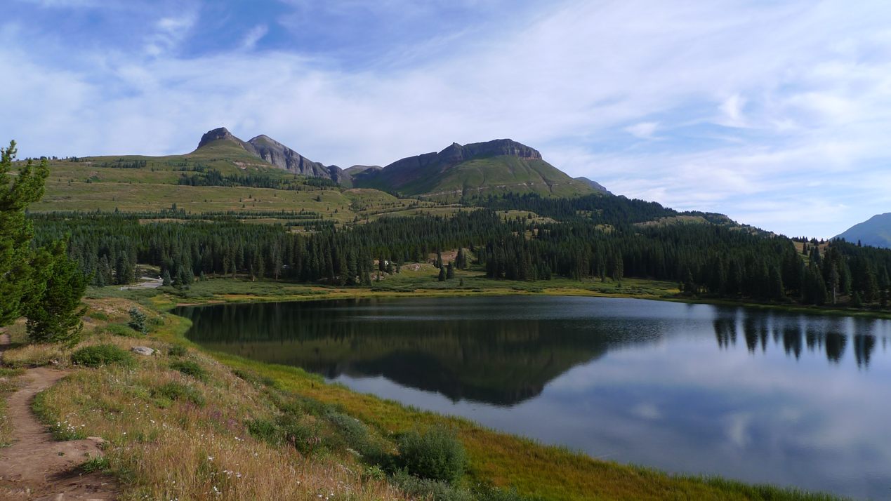
Starting out at Molas Pass

Wide open contour singletrack here. This is why I come to Durango.
Unfortunately, I learned later that Cathy just doesn't tolerate altitude well. They did not get far into the hike at all before having to turn around. Earlier in the trip, my mom noticed that Cathy's lips were a tad blue on the summit of Pikes Peak and Cathy was not altogether with it at 14,000ft. But even at 11,000ft, she has trouble. That was too bad, as the view from Engineer Mtn is one of the best.

Approaching Jura Knob at 12,000ft
I felt I was making pretty good progress on the Colorado Trail. I had ridden this section once before and knew what to expect and where the good photo ops were. I wanted to keep moving to beat the rain. It didn't take long for cumulus clouds to begin forming. I hate being rushed in a ride, but I had to at least reach Engineer Mtn Tr before any threatening weather formed. There was no other way down.

Looking south from Jura Knob. I believe that is Enginner Mtn
just poking into view on the left side of image. Hard to stay on
skinny ribbon with views like this.
I always seem to "forget" the challenging parts of these rides. The descent from Jura Knob involved a lot of hike-a-bike. Then again beginning the initial climb towards Engineer Mtn. With a hard week of riding in my legs, it took considerable mental fortitude to keep pushing.
I hadn't seen another person in over an hour. Suddenly, I hear a thump, thump, thump right behind me. I turned to look in terror, expecting some massive beast ready pounce on me. It was a runner right on my wheel. I thought I was doing well, but no. I thought about asking him if he had a few hematocrit points he could sell me. This was well above 11,000ft.
I reached the saddle at Engineer Mountain. Amazingly, there was cell phone coverage there. I called Cathy to give her an ETA. That is when I learned they did not make it too where I was now standing. There was a strong wind blowing through the saddle, the sun was still out, the temp mild, and the skies were still not very threatening. I could have relaxed up there all afternoon. I had the saddle to myself. Interestingly, there were people at the very summit of Engineer Mtn. It probably takes hours of rock scrambling to get up there from where I was. I would never have gone up there with the forecast. From town later, it did look like bad weather moved in.

From Engineer Mtn looking north. One of the grandest views
in Durango area.
The non-stop drop-dead views are not the only great part of this ride. The nearly monotonic 2600ft singletrack descent is another great part. It is my favorite trail descent. You pedal all of maybe 60 seconds in five miles of downhill bliss. It is steep in spots, bit rooty in others, but mostly just FAST.

The Engineer Mtn Tr cuts through many meadows on the way down.
You go so fast the colors of the flowers fuse into each other.
I finished with 21mi, 3200ft of climbing, in about 3.4hrs of riding time. It was a perfect ride. The trails around here are very well maintained, thanks to groups like Trails 2000. No wonder Durango is such a riding meca. Heading back into town, we all felt a tad unfulfilled. The women rented bikes to ride the bike path end to end (where there's just enough air for Cathy), while I did a second ride from town.
Horse Gulch
I headed out via the switchbacks prominently displayed from the north side of town up to the college campus. Fort Lewis College sits on a mesa about 500ft above town with some great singletrack hugging the rim. It is nice little touches like this that makes me want to move here.

From Rim Trail above town. Perhaps a little precip in distance
late in afternoon.
Heading east of the campus into the Horse Gulch trail system, I decided I felt good enough to venture further in than the last time I rode a token amount in this area two years ago. I rode out Telegraph Trail, not having any idea what to expect. It went up. A lot. The area is deserty and the soil is like baseball diamond grit. Really hard, really fast. I climbed up to the saddle where old telegraph poles still stand. I decided to take Crites Connect down, which merged into Carbon Jct Tr. This consisted of a four mile, beautifully contoured singletrack descent. Major score! I will have to do more riding in Horse Gulch the next time I visit Durango.

High up on Telegraph Tr in Horse Gulch.
The trail deposited me out on Hwy 550 well south of town. It took some crazy risk taking during rush hour traffic to get across many lanes of Hwy 550 to pick up the paved Animas bike path. This follows the river nearly all the way back to my hotel.
Ride two for the day netted another 22.9mi with 1800ft of climbing in 2.3hrs. There were sprinkles in town during the afternoon, but I never heard thunder. The day with minimal chance it stormed almost all day, and the day with much higher probability of storms, it stayed mostly clear. Nearly 12 hours of high altitude riding in two days put me into a stupor. Kids pay good money to feel that way. We ate at Gazpachos for dinner. We were warned it was spicy, and it was. The spiciness nearly had me sweating into my food. I would experience discomfort on the saddle the next day. Superb Mexican cuisine. I highly recommend it. Have to wait until after I get back home to put something up on my last ride of the trip on Friday. Attacked by border collies, close encounter with a bear, and fear of death riding. Good stuff.
2 comments:
Several years ago I did some mountain biking in Durango. One day, I rode the Hermosa Trail. I remember it being quite hard even though I did it the direction heading to Durango, where you lose vertical. I was passed in the other direction by world class riders who did it faster than me (while gaining vertical)...
One day I hiked to the Summit of Engineer Mtn. It was early August and sure enough, got caught in Thunderstorms while still up there. Very harrowing descent...
Nice, love that engineer mountain trail, descent to bottom of coal bank pass! Did it last year on my 29er unicycle, up Coal Bank Pass up the trail your mom and cathy were going up, then down engineer mtn trail. I agree the views to the north from top are BEST! So nice to hear you ended your Colorado trip on a good note.
Post a Comment