I've done the D2R2 ride many times from Deerfield. We start from a large hay field. Across the field to the east is a towering ridge that spans from south to north as far as you can see. I've heard you can ride that ridge. The heatmap showed many have. That clinched it for me. With any luck, there might still be some fall foliage in the area.
To plan this route, I decided to give the Strava Route Builder a try. I found it has some minor quirks, but it has something nobody else has: heatmap overlay! You can use street, terrain or satellite views, with or without the heatmap overlaid. Street and path following can be turned on or off. I found this to be the most versatile off-road route planning tool yet. Previously, I'd have to go into Strava Explore and grab tracks from specific rides. I had no idea if they were a one-off or followed a popular route. With the heatmap, you know exactly where the popular routes area. Readers will be sad hear this may spell the end of Hill Junkie boondoggles. The heatmap takes speculation out of route building.
The plan was to park in Greenfield, take 10 miles of paved road south to Mt Toby, which I hit on my ride from Amhest last fall. There is nothing super special about Mt Toby, other than it is a superb 1000ft fireroad climb from the north. Descending the south is a different beast. It is four miles of ATV chunder buried under fresh leaf drop. Momentum is your friend on the sofa bike!
There was 0% chance of rain and nothing on the radar when I headed out, despite some pretty ominous looking clouds. I no more than pushed off when it started raining. WTF! It sprinkled the whole way to Mt Toby, enough to make the road and my feet wet. It was less than 50F. Fortunately that didn't last long and wasn't enough to make off-road terrain wet. I never saw another person on Mt Toby until I reached the bottom on the south side.
Crossing back over the Connecticut River, with most of the paved riding behind me, it was time to traverse the Pocumtuck Ridge. The Mt Sugarloaf State Reservation is at the southern terminus. It is a popular state park with a grand view from the summit. I have always wanted to ride up this paved climb, but not necessarily on a sofa bike with sub-20psi in the tires. The leaf peepers were certainly out. The view was worth one more paved diversion.
I would be great to follow the Pocumtuck Ridge Trail all the way back, but there are pesky interferences, like big cliffs along the way, that would not be fun to carry a bike up. So a bit more road brought me around to the north Mt Sugarloaf peak, which goes higher than the south prominence and is undeveloped. I discovered the route that loops up and around the rim is superbly designed singletrack. Some more great views of the valley below along the way.
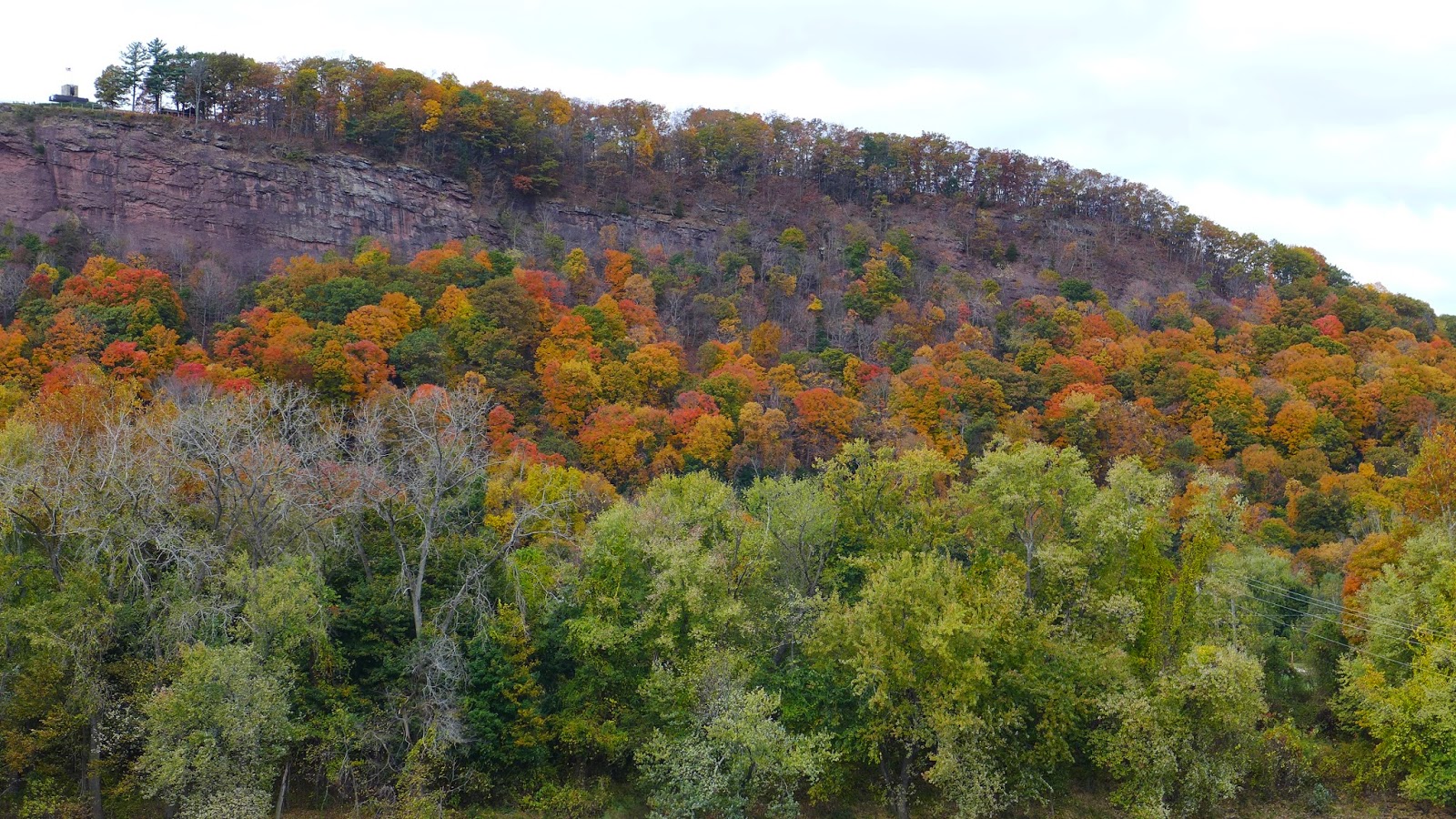
Dropping back down Sugarloaf, in no time I was climbing up to the Deerfield ridge. This turned out to be doubletrack. With leaf drop nearing completion up top, you could see through the trees in many places to gauge climbing progress. A few openings afforded great vistas too, such as the field the D2R2 ride is run out of.
Dropping off the Deerfield ridge, there was some great singletrack. Crossing over a dirt road brought me past a pack of mountain bikers and onto freshly leaf-blown singletrack. Sweet! No more apprehension of sliding out on hidden roots and slickrock. I expected New England ridgeline gnar on this ride, but thus far, there was none.
It wasn't until I got into Rocky Mountain Park in Greenfield that I finally encountered gnarly ridge riding. More great vistas of Greenfield along the way, but the ridge was getting pretty short, only a few hundred feet above town.
I got back to the car with 41mi, nearly 5000ft of climbing in 4.1hrs. Even though there was a lot of paved riding in this loop, it didn't seem like it. Paved miles go by quickly, and way more than half of the time was spent off-road. I'll do this loop again, maybe with a few tweaks, but it was almost perfect right off the heatmap.

Sunderland Fire Tower at Mt Toby summit

Heading down the Mt Toby AVT track on south side of mountain

The south and north Sugarloaf outcroppings
South Sugarloaf from the bridge over the Connecticut River.
Observation deck in upper left.

Mt Toby on left from Mt Sugarloaf with the Connecticut River in between

South Deerfield from Sugarloaf observation deck

Overlook from the north Sugarloaf peak

Slightly different angle from above photo

Pocumtuck Ridge view of the fields the D2R2 ride start in

Greenfield from Poet's Seat
8 comments:
Were you able to make the route mapper auto trace on top of the off-road heatmap tracks, the same way it auto traces on roadways? Or did you have to manually click hundreds of points to roughly follow the trail? I've never had luck getting it to auto trace on trails...but maybe with a premium subscription it does?
Nice ride and route! I love the exploratory rides in new areas/woods/mountains! Thanks for sharing!
Anon - I've had the same issue w/ the route builder, can't get it to create on trails. I'm not a premium member.
better riding in the area - connect.garmin.com/modern/activity/180125212
I'm a premium member, and no, I couldn't get it to follow heatmap tracks either if there were no underlying map features. Only when a trail was defined in the base map under the heat tracks did it follow. The other quirk is auto-follow did some strange things in urban areas. It would link through parking lots. So why would it take shortcuts like that but not follow hundreds of GPS tracks?? I do think the algorithm would be very difficult to get auto following on tracks alone. You need more user control features to help guide it too, I think.
Anon #2 - some interesting track there, especially around Sugarloaf state park area and up to north peak. Hard to tell where you went in though. Looks like Garmin does a lot of point reduction on the data set. Are the areas hit on this ride all legit, as in I won't have some deer hunter in his backyard taking pot shots at me?
its all legal - a hike a bike section along North Sugarloaf though to the trail you found. The riding north of where you were is good. If you're motivated enough you can connect the Greenfield ridge all the way to Factory Hollow - Gill - Northfield Mt. I'm not sure that I'd try to do it without having someone who knew where they ere going.
If you turn on "Manual Mode" at the top of the screen builder, you can place a waypoint anywhere, and with the heat map you can essentially follow it, just not auto follow the exact route. Have you tried this? I was wondering what the user experience would be like using it on the actual trail. I would think that you would at least be able to get a general sense of direction.
Sean - yep, toggled many times between manual/auto modes. I have done this a lot in DeLorme Topo, where I pull a bunch of tracks in from the web and then manual plot an aggregate route. Tedious. The result is only as good as tedious you want to make it. In areas where there is low density of trails, I place infrequent way points, as you just can't go off track. In dense areas or at busy junctions, I put more points to help me discern which way to go rather than having to sample multiple ways before I picked the right one. If you zoom in on this ride, you'll see a few places where I started to go the wrong way because it wasn't immediately obvious from what I was seeing on GPS. But overall, manual mode works pretty well.
If you decide to hit up the Northern Pioneer valley again let me know and I'll guide you a bit. - Not sure how to provide email addy without making it public.
Post a Comment