In June, a weekend was picked for the traverse. Soups, having nearly completed all 48 4000 footers in NH in the past year at that point, was already a seasoned hiker. Other seasoned hikers were on the invite list too. I hadn't hiked in a year. I know how DOMS (delayed onset muscle soreness) can be for a cyclist after even a modest hike. Now I was looking at an all-day hike with pros. This freaked me out more than a little bit.
So I made a point over each of the five weekends remaining to get a hike in. I hit the Tripyramids first. That nearly killed me, both literally and figuratively. Only 3000ft of climbing, and more importantly, descending, left me crippled for days. Four weekends left to build conditioning to do a hike several times more punishing. Panic set in.
I upped the ante over the following weeks, inducing DOMS that left me hobbling at the office on Monday mornings like I was 40 years older than I am. But the last weekend before the presi-traverse, I did 4500ft of vertical on steep Mt Monadnock with zero DOMS afterwards. That was encouraging. Now I just had to double the elevation and double the distance!
Getting up at 3am for a 6am rendezvous in the Whites sucked. I did sleep though. At least the forecast was not adding to pre-hike jitters. It was expected to be an ideal day. Mostly clear, temp into the 50's at elevation, very little chance for rain. You still have to pack for the worst though. People have died from exposure in the Whites in August. I bought a large hydration pack with enough room to hold winter layers, emergency bivy, first aid kit, more than enough food for the traverse, and of course three liters of water. I have never hiked or biked with so much weight slung over my back.
Soups, Tim Lucia and I began our hike at 7am in Appalachia on the Valley Way trail. The 3500ft gain to Madison Hut went by in no time. I felt good. At least I had the sense to not bury myself on the bike during the week. From the hut, a spur is taken to summit of Mt Madison. We go up that?! Where's the trail, I thought to myself. There was a lot of traffic from folks that started their day much earlier. The view from the summit provided a different perspective on Mt Washington, which I've climbed so many times by bike. Interestingly, almost half the day's climbing was complete after bagging that first peak. That didn't matter to me. Almost none of the day's descending was complete. It was the 8000+ feet of descending continuous rock garden that was going to destroy me, rock by rock.
Mt Adams was next and it looked even more formidable. Not having been to any of these peaks except Washington, I saw a trend emerging. Hike a thousand feet up a massive rock pile, descend, repeat. Above tree line, the continuous post card views kept the mind off how badly my body was going to deteriorate before the end.
Looking at the profile for this hike, each summit appeared as a little bump. That is so deceptive though, because those little bumps are scaled by the 3000ft just to get up here. Each little bump took more than an hour to go up and over, often requiring at least some hands to scramble the steepest parts.
Mt Jefferson was the next peak, going even higher than the first two. So far I was feeling pretty good, but after the descent from Jefferson, my knees were starting to feel a little wobbly already. Even though more than half of the climbing was behind his, we barely made a dent in the descending.
Mt Clay was next, another tough climb, with fortunately little descent on the back side. The whole time, the Mt Washington summit loomed before us. Finally, we began to tackle this one as we hugged the rim of the Great Gulf Wilderness.
The summit of Mt Washington was a circus. I thought on the bicycle race day things were busy up there. Nope. With two cog railroad trains running and steady stream of cars and motorcycles heading up, Soups likened it to "the mall at Christmas." Just nuts. Fill our water and get out of there.
Unfortunately, it was a bit of a conga line dropping down to the Lakes of the Clouds hut. Mostly tourists who didn't have the "trail awareness" that more experienced hikers have. Still good to see people getting outside and off their butts. The entire south Presidentials were visible from the south face of Mt Washington. It looked so tame, like almost no elevation change and smooth. The scale of how far down the ridge you see dupes one into believing it's going to be easy.
Serious knee and ankle fatigue was setting in. I brought my ankle braces along and had planned to put them on at the Washington summit, as that's when the descending elevation change begins in earnest. But I wasn't having trouble with my ankles turning, and those things cause hot spots all around my feet, so I left them off for the time being. I did hike with two poles, the first time this summer. Even though they got in the way on the steepest parts, the poles were proving to be a huge help in stability and in taking some of the pressure off my knees dropping down big steps.
Only three peaks remained, Monroe, Eisenhower and Pierce. Once away from the Lakes hut, the crowds thinned out considerable. There were times we could see no other people on the stretched-out ridge line before us. I didn't like the fact that each time we climbed, we had to descend that same vertical over again. The climbing was fine, the descending was getting more and more tedious for me. I took two Aleve in hopes of easing knee and ankle pain. Soups and Tim were gapping me on the descents.
We finally reached Mt Pierce. The view back towards Mt Washington was pretty sweet, with how the sun was hitting it. From here, it was all downhill back to the car. Tim was saying this like it was a good thing. I would have much rather climbed 2500ft from that point back to the car than descend 2500ft back to the car! Soups was saying, "don't worry, it's a really easy grade." Yeah, right. It was not steep, but the entire 2500ft was wet baby head rocks! Soups was like "but it wasn't like that this past winter." Yeah, with six feet of snow on the ground. How I survived that without face planting, rolling an ankle or just stopping to cry for while is beyond me.
I would never have thought the sound of motor vehicles would be music to my ears as we approached Crawford Notch on Rt 302. We finished with sunlight to spare. The hike covered about 19 miles in 11.4hrs total elapsed time with 8600ft of climbing. I'd say that that was the hardest one-day activity I've done, as far as pushing through physical discomfort. It is a different kind of wrecked than what a hard bike ride leaves you in. The hike was never taxing in a cardiovascular sense. It taxed my all my joints, even my shoulders, as I became increasingly reliant on the poles toward the end. Still though, it was my most rewarding day in the White Mountains to date.
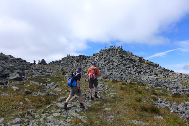
Soups climbing Mt Madison with Madison Hut below
Myself on Madison with Washington in background
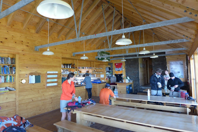
Inside the Madison hut
Soups and Tim heading up Mt Adams
Mt Madison from Mt Adams
Mt Adams summit with Washington obscured by cloud
Thunderstorm Junction
Tim heading up Mt Jefferson
Approaching Mt Jefferson Summit
Mt Jefferson with Mt Clay and Mt Washington in background
Heading to Mt Clay
Looking back at what we covered so far
Soups on or near Mt Clay
The Great Gulf Wilderness
Tim and Soups approaching summit of Mt Washington
Tim overlooking Great Gulf Wilderness
Soups gazing into Great Gulf Wilderness
Line of tourists waiting just to have picture taken a the Mt Washington summit sign. Photo only counts if you hiked or biked up here!
Conga line from Mt Washington summit to Lakes of the Clouds hut. Whole southern Presi's
in this shot.
Approaching Lakes hut.
From Lakes back at Mt Washington
Tim and Soups at Mt Monroe with Dry River Wilderness below. I thought this was
the best view on the traverse.
Two more to go, Eisenhower and Pierce.
Grades were tempered along the southern Presi's, but footing was never easy. Looking
back over Monroe with Mt Washington in distance.
Eisenhower and Pierce in distance. Finally away from the masses.
Looking back at Washington.
Tim and Soups on way to Eisenhower.
Last summit, Mt Pierce, looking back at the southern Presidential range.


1 comment:
Doug: with the downhill of the presi under your belt, you might want to consider the great range traverse in the adirondacks; 22.5 miles and 10k ascent...we just did the grt this week, 2 weeks after the presi -- consistently steep with big boulders and fun scrambling...
Post a Comment