Not that hiking is easy. Some hikes start out with a 3000ft climb in just a few miles with no warm-up going into the climb. I love long monotonic climbs. I quickly get into a grove, a nice steady tempo pace and find my flow state. Climbing a steep mountain on foot can put me in a flow state quicker than riding can. Maybe it's the slower, rhythmic pace of it. I've felt this way about skate skiing too.
This weekend I pushed myself pretty hard on a 50 mile trail ride near the coast on Saturday, hitting Bradley-Palmer, Willowdale and Georgetown-Rowley state forests. There are many miles of near road bike speeds mingled in my loop, but there is a healthy dose of super chunky New England tech in there too. Couldn't even walk right after that one.
Then Sunday, I headed up to the White Mountains on a whim. I said I wasn't going to fight the traffic on I-93 coming back again, but funny how a week goes by, you miss the mountains, and forget how bad 93 sucks southbound on Sunday evenings. A loop I threw together in my head would climb Ammonoosuc Ravine Trail, loop over Mt Monroe, head north over Mt Washington, loop over Mt Clay, then down Jewell Trail. I had not hiked any of this stuff west of the ridgeline before. Had wanted to hike Ammo for a while now.
Forecast showed slight chance of rain in the area, but Mt Washington Observatory said in and out of the clouds, windy and high in the 40's. Sounded good to me. There was a ranger with info table set up at the Ammo trailhead lot at 10am. Summit looked very dark and scary. I asked if it was raining up there, he said no, but probability goes way up at 11am and up more later in day. Great. Takes about an hour to reach the ridge. Some warm layers and Goretex went in the pack. I was surprised how much parking space was left in the lot. Where was everybody? Many of the other lots driving up were only partially full too.
I felt half-way decent heading up Ammo. Didn't take long to overtake most of the people that started much earlier. Overheard comments I've heard many times now while heading up. I'm in cruise mode, light to moderate tempo pace, which means not breathing very hard, not audibly anyway. People see I use poles and see I can scoot right up steep slab or big steppy stuff. Not hardly breathing. Then I hear "see dear, that's what we need!" Or "see, that's how you do it!" Implying that all you need are poles and they too, can scoot right up steep stuff without slowing down. Little do they know I bring two decades of competitive cycling fitness to hiking.

Falls on Ammo. A dip would be nice, then I'd spoil all those prize photos people try to capture here.

Cascades further up Ammo

Looking over cascades on Ammo
I have never gone against the clock on a hike. I am curious, maybe give an uphill a go sometime. Chris Dailey better watch out! Just kidding. The thing is, I suck-ass going down. I'm pretty sure on most terrain in a time-trial scenario, I will be faster going up than back down the same trail. This would be particularly true of the trails I hiked today.
It took about 70 minutes to reach the Lakes Hut. Mt Monroe was in the clear. Bonus! But I no more than started heading over to Monroe when the whole ridge just suddenly blanked out with clouds. Crap! I had forgotten to put a memory card in my good camera anyway, so maybe I won't be so mad about that now and just enjoy being socked in my own little world.
I was soaking wet with sweat and the temp was probably not more than 50F and the wind was really ripping. I stopped to pull off my soaked top and put a dry long sleeve thermal layer on. It was cold enough to make my nose run and wind was whipping snot all over my glasses. The Presidential Range in August!
As I climbed the wee bump that Monroe is, the orographic cloud deck started to lift again. Maybe I would snag a view or two after all. As I approached the summit and visibility improved, I realized there was nobody else on the summit! A Presi peak to myself on a weekend in August? It was one year ago this weekend that I completed a Presi-traverse, and the peaks around Mt Washington were mobbed.

Lakes of the Clouds Hit. A photo can't depict how dynamic this view was. This clouds were forming in place and ripping over the ridge at 50-60mph.

Posing near Mt Monroe summit, devoid of people

From Mt Monroe, looking back at Lakes, Mt Washington directly in background socked in
Ah, that's more like it! The southern Presi's.
After spending a few minutes there, I hopped down the south side, got on the Crawford Path and headed back to the Lakes Hut. Mt Washington was still socked in with very dark clouds. There were more people now, but not mad numbers. I could still keep a pretty good rhythm going and rarely got bogged down. Most stops were of my own doing to take photos.
For an instant, the cloud deck almost lifted above the Washington summit. Just a teaser. As I approached the summit, visibility was terribly poor, maybe only 50ft at times. Most people up there were dressed almost for winter. The towers and buildings were catching condensation, and the wind was ripping it off, making it feel like it was raining up there. But it wasn't.

The teaser. Mt Washington summit almost in the clear.

Looking back at Mt Monroe while approaching Mt Washington summit cone. Where is everybody?

Further up summit cone, passed a few peeps on the way

Ugh. Couldn't see squat as I popped out on the summit

Only a handful of people waiting to get summit photo. Mostly winter clothes up here.

Choo-choo. Diesel. Do they run the coal engine anymore?
I next planned to take Gulfside trail down to Mt Clay, but I couldn't find it! I went in circles in the abyss. Found Nelson Crag. Not it. Found Crawford. The way I came up, not it. Gulf side was supposed to be in the middle, but I couldn't see shit. Finally I found it behind Tip Top House. Maybe there was a sign out front somewhere, but I couldn't find it.
Going down Gulfside Trail was pretty tricky. My legs were getting a little noodly (remember I destroyed them on the bike the day before?). It was loose scree. As I reached the saddle with Mt Clay, I turned around to see Mt Washington summit in the clear now. Figures! Not all was lost. The rest of the northern Presi's were in the clear now too, and that view across the Great Gulf Wilderness does not suck.

The Great Gulf Wilderness with Jefferson, Adams and Madison flanking the north side

Mt Clay in the clear now

Mt Washington in the clear, now that I'm not up there anymore! Two cog cars coming down.
I passed a couple others dropping down the Mt Washington summit cone. A cog rail train was heading up. An AT through-hiker, a woman, said oh shoot, AT hikers are supposed to moon passing cog trains! That's hilarious, I hadn't heard that one before.
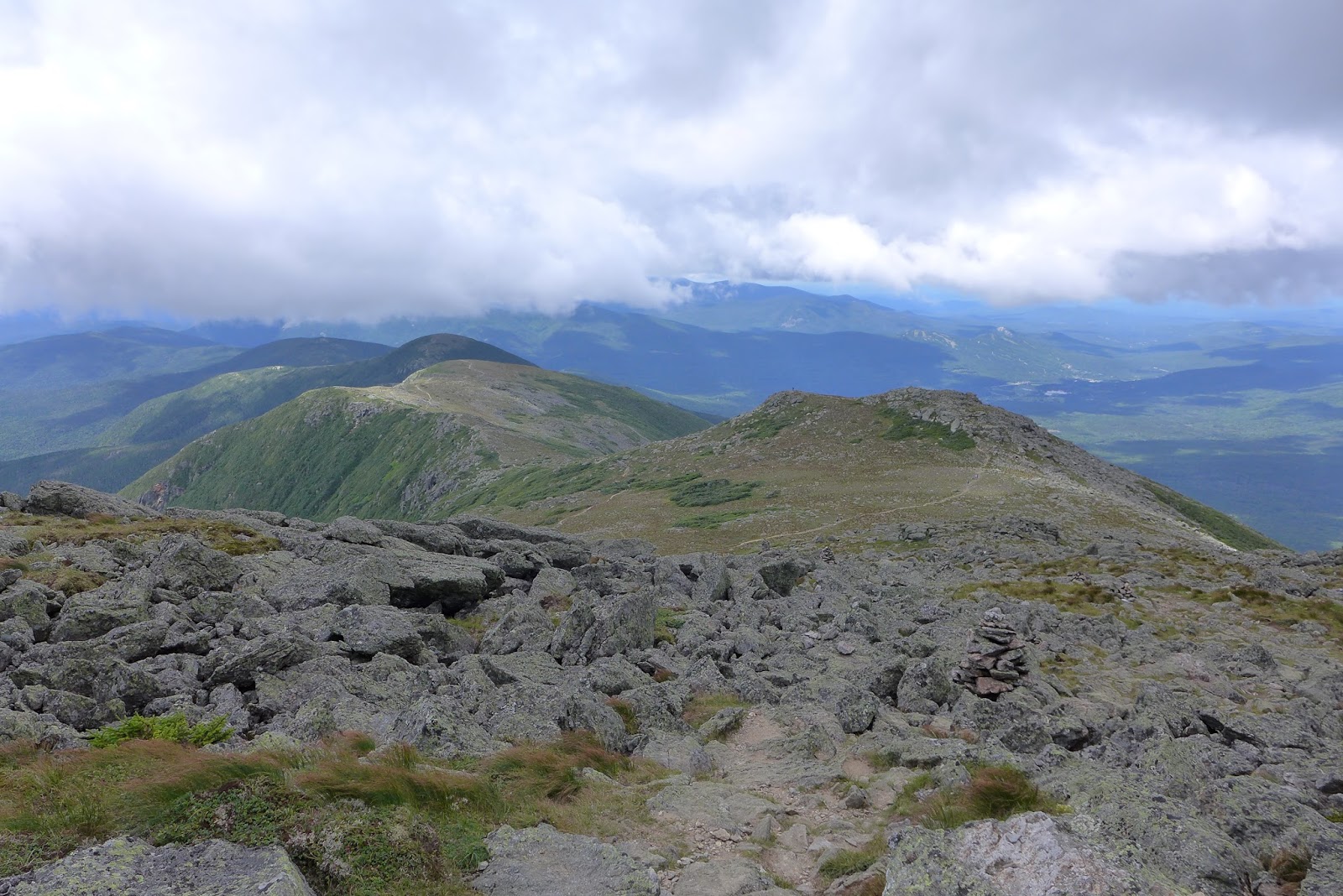
Once I got off Washington's summit cone and started hitting the Mt Clay humps, there were no other people in sight. Again unexpected, to have another Presi peak to myself on what was turning out to be a fine day above treeline.
Hiking down the north side of Clay was also super challenging. Lots of unstable footing there. I had hiked up that last year and probably thought nothing of it going up at the time. Little did I know, that once I dropped 500ft down to pick up the Gulfside Trail again to head back to Jewell Trail, I'd be climbing right back up most of those 500ft on unstable rock!

Mt Jefferson. Not a person in sight. Kinda wanted to keep going that way, but then how would I get back to my car?!

The Great Gulf headwall and Washington summit

Heading down Mt Clay with Jefferson opposite. Strapped my t-shirt to Camelbak in hopes it would dry out before putting it on again at lower elevation.

Mt Clay loop trail. Super hard on my ankles.

Cog Railroad base center, Bretton Woods ski area beyond

Jewell Trail just before it tips off ridge into treeline.
I read somewhere that Jewell was the easiest trail to Mt Washington summit. I thought there was nothing easy about the top 1000ft of vertical of Jewell. Once back below treeline though, the lose rock turned into stable footing the rest of the way down.
Turned out to be a great little hike, about 5500ft of climbing in 12 miles. It was nearly a pure loop. Hikes like these have all the attributes of what I look for in bike loops too. Monster climbs, challenging terrain, and great scenery.
In four weeks I head to Colorado for two weeks. My mountain bike will go with me, but also my hiking gear. The trip will still be cycling-centric. More than half of the days will be riding-only. One or two days may have short spur hikes to 13er summits during rides. 2-4 days will be hiking-only days, where I plan to hit some of the 14ers. I will value some of the less popular, perhaps less accessible hikes for some solitude and get away from motor vehicles. There are many expansive wilderness areas in SW Colorado to find some solitude. I ordered a PLB transponder, as most areas I will go into have no cell phone coverage. Have to keep the misses happy. Looking forward to Colorado.
2 comments:
I see someone made a new website out of northeastcycling.com
Wow, the same day I told Lycos to F*** off after fighting them for two months to get my domain name back, the name is re-registered. It was like somebody was waiting for it. Thanks for pointing it out. If my website had been an income producing website, I would have taken Lycos to court. They never gave me a straight answer for what happened.
I sure hope whoever took northeastcycling.com gets my permission to use any of my content. They mentioned resurrecting some of that material on their new site. My original content can be found on archive sites. As originator of that content, I posses the copyright to it. http://mason.gmu.edu/~montecin/copyright-internet.htm
Post a Comment