Wednesday, September 1, 2010

Monarch Crest West Loop

Distance: 36.4 miles
Climbing: 4600 feet
Riding Time: 4:43 hours
Min to Max: 8500 to 12,000 feet

I've ridden the classic Monarch Crest ride multiple times now. Most riders used automobile shuttles to start themselves off near 12,000ft at Monarch Pass. I've always started from Poncha Springs and rode Highway 50 all the way up. The only thing that sucks about the climb is the traffic. Hwy 50 gets a lot of trucks. There isn't much shoulder on most of it either.

The classic route follows the Continental Divide past Marshall Pass, where Silver Creek is taken down to the Rainbow Trail. The Rainbow Trail is a real gem. It is a lot of work, especially for those that climb 4000+ feet up Hwy 50 to start the ride. But there is another option to ride the crest that is almost all on dirt. It is on the west side of the divide. This option starts in Sergents, takes dirt Old Monarch Pass road up to the divide, where the CDT is taken two miles to Hwy 50 at Monarch Pass (the new one I guess). Then since your car is at the bottom on the west side, a different trail must be taken down. Agate Creek is the option I chose. The whole loop runs about 36 miles and has a little less climbing than the classic loop since Sergents sits higher than Poncha Springs.

Old Monarch Pass Rd up on the left, Crest across the top,
Agate Creek Tr down on the right.

Interesting that I can spend two days at 6000ft, ride to 14,110ft, and not get an altitude headache. Then I go to Gunnison (elevation 7700ft) and wake up with an altitude headache the next morning. My experience is if I start the day with an altitude headache, it only gets worse when climbing. I planned to spend a lot of time at 12,000ft. It was the third day at altitude, usually my worse.

On Tuesday morning, I started off at 8:30am from Hwy 50. It was cold. I needed a long jersey until I warmed up. A few miles of pavement are taken before reaching Old Monarch Pass road. This gravel road was in mint condition, road bikeable in fact. Never very steep either, typically 8% in the switchback sections, of which there were three sections. The divide is reached in 14 miles and over 2500ft net gain. I went 90 minutes before I saw or heard another person. I savored the solitude.

Old Monarch Pass Road near the summit

The two miles of Continental Divide Trail (CDT) to Monarch Pass was sweet contour singletrack. A couple switchbacks dropping down to Hwy 50 at the top of the pass were steep though. I refueled at the summit store. I was about 2hrs into the ride. It was chilly and windy up here, necessitating the long jersey again. There were many riders unloading bikes here, including an international couple on singlespeeds that I later met on the trail. They planned to hitch-hike back up to their car.

Monarch Crest Trail

More Crest goodness

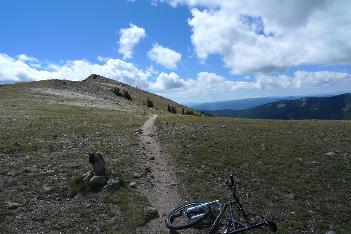
The Monarch Crest portion of the CDT is one of my favorite trails. It cruises along the continental divide at 12,000ft, above timberline, for several miles. It is buttery smooth most of the time, but it would be a waste to blast through it with incredible views on both sides of the divide. I passed a large group of riders before reaching my turn-off at Agate Creek. Other than that, I almost had the ridge to myself. I rode a total of about 13 miles above 11,000ft.

Self portrait on the Crest

Agate Creek Trail was new for me. I knew it dropped steeply. The first two miles were non-stop death grip on the brakes. This trail is open to motos too, so it was pretty chopped up. It was very technical. A rider in the group I passed told me I was going to get wet feet on Agate Creek. Lower down, the trail crosses the creek many, many times. Each time, the stream got a little wider, a little deeper, and a lot more risky to try to ride across. Dismounts became frequent. I had forgotten my ankle brace on this ride. On the bike, I was more worried about going over the bars on this rocky trail than hurting an ankle. Off the bike, walking across rocky bottom streams was an ankle fracture waiting to happen. I was very tentative on this descent. It took me a long time to reach the bottom. Once the end is reach, a wicked steep set of switchbacks is taken back up to Hwy 50. I had to walk bits of this. The trail popped out about two miles from my car, which was a nice coast back down. My altitude headache never became a problem during the ride and was gone by the time I finished.

Top of Agate Creek Trail

I really liked this new, almost all dirt option to ride the crest. The descent is pretty bony, and you do miss the Rainbow Trail on this side. But it sure beats riding for better part of two hours up Hwy 50. The ride went 36.4 miles with 4600ft of climbing in 4.7 hours riding time. I was completely cooked when I got back to the car. I couldn't get to Sonic quick enough for a large malted milk shake.

Wednesday was one of my best trail riding days ever. The weather has been nothing but perfect here, 70's, no humidity, breezy, and brilliantly sunny. Wouldn't it be a shame if Hurricane Earl forced me to stay here an extra day or two?  I had to do two rides on Wednesday. Never let a perfect day go to waste. This will have to wait for another post.

Tuesday, August 31, 2010

Incline Insanity

Monday morning Tom took me over to the Manitou Incline. It is the old bed of a cable tram that hits a maximum gradient of 68%. There are some great historical photos here.  It rises 2000ft in about a mile. The railroad ties are still there. At that steep of a grade, the steps become huge. Each step is a one-legged, full body weight press. UltraRob notes 2744 is written on the last tie. Another hiker attempted to count them on Monday. He said 2950, plus or minus 100, and he counted missing ties (empty spots where there should have been one). So you get the idea.

Many athletes train here. Elite runners and cyclists alike. In fact, Chris Carmichael and his athletes have been seen time-trialing up this beast. The record is around 17 minutes. Tom Ramsey's best is just over 32 minutes I believe. The incline starts at around 6500ft and tops out at 8500ft. The air gets pretty thin up there. Tom has lived in Colorado Springs for a couple years now, so he's fully acclimated to 6000ft. I get dizzy just going up the stairs in Tom's house.

Checking out The Incline the morning after climbing Pikes Peak is a rather sadistic thing to do. But when you are in Colorado Springs, it is one of the things an athlete must check off his or her list. Both Tom and I complained about our hip flexors hurting when we got up. It seems when you climb so long with no recovery, you begin to recruit less conditioned muscles as the well conditioned muscles crap out. Trainers will push their athletes into this regime to improve performance. It sucks working in this regime though, because you feel like dog poo. Fortunately, hiking up a steep grade doesn't demand much from hip flexors. It does demand a great deal from quads and calves.

The Incline faces directly into the morning sun. It was warming fast. We parked downtown. It was more than a mile to the base of the climb. A good warmup. Looking up at The Incline is daunting. It looks so steep that if you tripped, you might rag-doll all the way back to the bottom. Hikers have been seriously hurt on this. A portion of it is on private property and is posted as such. The town is working to remedy this, so the public can have legal access.

The scar up Mt Manitou is The Incline

Tom and I got right down to business when we reached the bottom. He let me lead. I guess he didn't want to crush me two days in a row. A different route is taken down, so I did want to take a couple photos with minimal stopping.  My heartrate immediately redlined.  My quads screamed. It seems hard at first, but by the middle it becomes almost impossibly hard. Early on a weekday, there were a couple dozen other people on it. Most had to stop frequently. A few ran past us like we were total Freds. By the mid point, the thought occurred to me that I went out too hard. At least Tom was breathing really hard too, right behind me.

Near the bottom. Note the moon.

We reached the top in about 35 minutes (I forgot GPS, so I only had minute resolution on cell phone). Tom later commented that he didn't think he had a 34 in him that day. Maybe he said that just to make me feel good. I gave it everything Pikes Peak left me with. I'd say hiking this is comparable to riding Mt Ascutney, except your heartrate runs exceedingly higher. For two reasons. One, hiking is weight bearing, the other is thin air. Perhaps locals don't get as racy of a HR as I did.

Near the top with Tom in foreground and Manitou Springs below

If I lived in the Colorado Springs area, I would totally do this on a regular basis. It would be superb conditioning for both cycling and XC skiing.

The hike down consists of a connector trail to the Barr Trail. The Barr Trail goes to the summit of Pikes Peak. I studied riding up this on a mountain bike to bag Pikes Peak before the Assault was organized. I am so glad I never attempted it. While it would be technically rideable, its steepness to altitude ratio is such that it would have been one massive hike-a-bike for me. The trail surface is decomposed granite, great to ride on, but dicy to hike down. My feet went out from under me once, coming down and my hands hard. I did wear my ankle brace for this.

Barr Trail

Altogether, Tom and I hiked 2.6mi round trip in town to trail head plus 3.7 miles of trail in about 2.4 hours moving time. My calves were wrecked. I didn't seem to have too much trouble coming back down.  Perhaps the Monadnock hike a couple weeks ago took some of that edge off.

I thoroughly enjoyed my stay with Tom and his wife Mick in Colorado springs. Had Tom not mentioned the Pikes Peak event to me, I probably would not have learned about it.

My ride on the CDT today was spectacular, although quite brutal. It seems I'm a day behind on posting, so that report will go up Wednesday.

Monday, August 30, 2010

Batteries and high hemotacrit have value

First Annual Assault on Pikes Peak

Sunday set up to be a spectacular day for a 14er hillclimb. Highs near 90F were predicted for the Colorado Springs area with minimal chance for rain. I botched my sleep up though. Tom is an early riser. I begrudgingly set my alarm for 4:55am (he got up at 4), but I somehow managed to set the clock an hour fast. I got up at 3:55am. There was no way I could sleep some more after that.

We did bib pickup the evening before, which included a pasta dinner. Wasn’t bad. Red Noland Cadillac is the prime sponsor for the event. From what I heard, without their generous financial support, this event would not have happened. Bib pickup was at the dealership. Beer and wine were included.

It was still dark out when we got to the race start. The timed “but-not-a-race” event started at 7am. Just over 300 riders were present, set to go off in one wave. I saw every kind of one, two and four wheeled contraption there. There was Aspen Mike on his unicycle, a couple on a tandem, recumbents, a paraplegic in a handcycle, and get this, a posse of battery assisted bicycles. I have a hunch the event director will hear a good deal from the human powered majority about this.

Staring area before 7am. Pikes Peak lit up in distance,
The Incline visible on right (story next post).

I sent a few clothing items up for the descent in my Camelbak. I was riding up with nothing. No spare tube, pump or long layers. Just one gel and one water bottle. It was breezy and about 60F at the start.

I did not warm up whatsoever.  I somehow staged behind one of the battery powered guys. He didn't go out very fast.  I placed myself way too far back and was nervous going through the Manitou Springs village. A lead group bolted and was gone. Tom Ramsey was in that group. I didn’t really care about getting stuck back, as I was going to take pictures on the way up anyway. I just didn’t want an inexperienced pack rider to take me out.

Heading out of town towards US-24, the grade kicked up and thinned things out. I stayed with a small group that went at a pace I was comfortable with into the moderate headwind. We got on US-24 via the off-ramp. The police had shut down one of the two east bound lanes for the hillclimb. Thus we had a lane of a divided highway to ourselves for several miles. This was against traffic. They did it this way so we wouldn’t have to cross the highway twice. It worked.

The grade thus far was relaxed, maybe 5% average. When we got off the highway, we hit some steep bits. This was maybe 6-7 miles into the climb, but not much vertical yet. The Pikes Peak Toll road was closed to cars for the hillclimb.

First photo I took during the climb, about 7 miles in just on toll road.
Summit wasn'tgetting any closer.


I knew from studying the profile, that the climb doesn’t really start until about mile 14, or above 9000ft elevation. The grade kicks up there with a vengeance and stays that way for most of the remainder of the climb. It was along here that multiple motorized bicycles passed me. You’d here them coming. The riders still had to pedal. I talked a good while after the climb back at the bottom with an E-bike rep about these bikes. More on that later.

I stopped to refill my water at around mile 12. I thought, wow, half way miles-wise, maybe this won’t be so bad. I had no idea what I was in for. As expected, the grade at mile 14 kicked up something fierce. My pace dropped dramatically. I didn’t run the Garmin, but I bet there were many 12+% sections. I was geared at 34x28 minimum. At altitude, this put my cadence painfully low.

A typical switchback. Taken on descent.

Mt Washington has the 5 mile grade. Many readers will know about this. It is that dirt section at mile post 5 where you see forever, and it is all 15% grade. Well, Pikes Peak has the 15 mile grade. It too is dirt, steep as heck, and the summit isn’t getting any closer. That is what was so demoralizing about this climb. You’ve been climbing for well over an hour, and it doesn’t look like you’ve even made a dent in reaching the top.

Over half way and summit in distance is still impossibly far up.

At 12,000ft, you leave timberline for good. And this is where things got really interesting. Not only do you have double digit grades, not only was the air become rarified, but you also had 50mph wind gusts. Oh yeah, this was way harder than anything I’ve seen on Mt Washington. I thought to myself a shit load of people were going to be in trouble here. In fact, multiple people riding around me had to catch themselves by putting a foot down. At times my speed dropped to 3mph and I was going all-out as hard as I could. The wind was whipping up pea sized gravel into my face. It was getting inside my shoes. I learned at the top that the wind ripped Tom’s shades right off his face. I think the last 8 miles took me much longer than the first 16 miles. I spent long stretches with my cadence in the 40’s. I had some serious reservations about descending in this wind.

The temperature was also plummeting as we climbed. My hands grew numb. So did my ears, nose and feet. If I had flatted here, I would have been in a world of trouble. There were bits where the head wind became a tail wind. This was sweet. I remember one stretch were I accelerated up to 35mph about two miles from the summit and felt zero net breeze. This was steady wind speed. Going around switchbacks was so tricky. You’d lean 45 degrees into the wind on one side then have to abruptly transition to leaning the other way. One rider near me gave up and walked.

The sky stayed nice and clear though. There were no ominous clouds building. When we cleared the last water stop, I saw a large group of riders coming up behind me. Even though I stopped multiple times to take photos on the way up, I did not want this group to pass me. I somehow found some more energy. By this point in the Mt Evans climb a couple years ago, I was cramping up horribly and getting an altitude headache. Not today. I felt great. I managed to hold that group off for the last thousand feet or so of climbing. When I reached the 14,110ft summit, I couldn’t feel the shifters whatsoever. The temperature was probably less than 40F and the windchill around freezing. Overnight the windchill was reportedly 15F.

I logged 3:04hrs riding time, and my given time was 3:09:23, good for 27th place out of 312 starters overall. Tom slayed this climb in 2:56:23. He's a phenomenal climber and could challenge the Mt Washington age group record when he turns 60.  He just had a physical and his hemotacrit is many points higher than mine. Time for me to buy that oxygen tent. Or move to Colorado. This was easily the hardest timed hillclimb event I’ve done. 3hrs, no recovery.

They fry fresh donuts at the summit house. That and a hot cup of coffee did wonders for my hands. My core body temp was barely ok. I didn’t start shivering until after I sat down inside. Those were the best donuts I ever had. Maybe it was a timing thing.

Hour of vertical in single frame.

After taking in the summit views, it was time for the nearly 8000ft plummet back to Manitou Springs. I heard some riders say they were taking van transportation back down because of the wind. Screw that. What I saw on the descent shocked me. There were still many, many riders hours from the summit, walking their bikes up. I knew many would underestimate this mountain. I felt sorry for them. What do you say? Looking good! Almost there! Many of these people had little chance of making the summit before being turned around by event staff.

Mike Tierney on Uni. He finished in an impressive 4:40.

Walkers coming up on my descent, far from summit.

The first two bikes to descend from the summit as I finished my climb were battery assisted bicycles. This event is a timed, USAC sanctioned fun ride, but not officially a race. The two fastest motor-assisted riders do have asterisks by their names in the results. Seeing them there rubbed many human powered athletes the wrong way. Why would you allow motor vehicles in a bicycle event? Where does this end? I suspect with my robotics background I could build a battery powered cycle that could reach the summit in an hour. The technology will only improve and the motor assisted bikes will get faster. What is the point here? Clearly the event director needs to deal with this next year.

Buttery smooth pavement and miles and miles of switchbacks.

There were event booth displays in the park at the bottom. A couple vendors were E-bike vendors. I talked with one at length. He was surprised that anybody would care a motorized bike was participating. He said to me, “you mean this could be negatively perceived?” Well, yeah! They were there to promote environmentally friendly transportation options. But they were very naïve to think they could do this in a human powered timed event. I don’t think they should even have a separate category during a bicycle race. Pick a different day and a different event. Electric bicycles and the human powered counterparts will soon not mix well at all.

Looking down on Hwy 24 from toll road. Lane closure did
appear to have some impact on traffic. Hopefully minimal.

I have to say the technology has progressed. These are not the stealth E-bikes that made a buzz recently. These bikes pack batteries with 1000W-hrs or more of power. They are quite conspicuous. There were at least six of them there. One guy had a completely homemade job, which looked like two small car batteries with what looked like a car alternator turned into a motor. Probably not very efficient.

Obligatory summit photo of Tom and me.

It was a great day of riding, just over 4hrs total. This hillclimb event made the greatest impression on me of any. Mt Evans better watch out. Mt Evans is just a warm-up climb to this beast. Mt Washington will lose its “toughest hillclimb” label. With the steepness, exposure to wind, thin air, and 60% greater net gain, Pikes Peak could easily claim that title. The event was very well staffed and orchestrated. Only 300+ entrants started this year. Organizers were hoping to sell out at 1500 riders. I think they just didn’t get the word out. Now it will be out. I think Pikes Peak will sell out next year. They plan to offer it again. You can’t ride your bike on this 14er otherwise. Asking around, there were only two prior bicycle events on Pikes Peak. One was 1986 world championships, the other around 1991. They both started much higher up than Manitou Springs, and nobody rode back down. This event was a first of its kind. The scenery above tree line is surreal. You get a strong top of the world sensation on this mountain. I wouldn’t do the Mt Evans hillclimb race again, but I’d definitely do Pikes Peak again.

All for now. Hopefully I can catch up on blogging Tuesday night and tell you about the Manitou Springs Incline. I did it Monday morning. Nasty, nasty. As a hurricane is bearing down on the east coast, the forecast here looks perfect. Tuesday I plan to mountain bike a portion of the Continental Divide at 12,000ft. I'll leave you with two Pikes Peak summit photos.  Thanks for reading.

West view from summit

North view from summit

Friday, August 27, 2010

Must do in Manitou Springs?

Discussing plans for Monday, Tom Ramsey suggested I try The Incline. He said it was a "must do" activity when visiting Manitou Springs. Now I had heard of this beast before. It is essentially railroad tie steps all the way up, 2000ft in a mile, or greater than 40% average grade. The grade in the middle looks more like 50-60%.  Oh, it starts above 6000ft too. People run up this thing. Record is something like 17 minutes.

So I was like, I don't know, that sounds like major DOMS attack midweek when I hope to be enjoying singletrack. Tom said you can take a trail back down that stretches that 2000ft out over three miles. That still way steeper than Mt Ascutney. Any chance I still have some conditioning left from hiking Monadnock a couple weeks ago?

So I got to the bottom of Tom's strong persuasion to get me to try it. He wants to see me suffer. My curiosity is certainly piqued. I could label it as Ironcross and ski training.  I'll see how I feel Monday morning. Just maybe I'll give it a go.

Thursday, August 26, 2010

Colorado

Early this year, I learned I got into the Leadville 100 mountain bike race. I was ecstatic. But nobody I knew well got in. I later learned only 1 in 6 made it through the lottery process. Then this spring, a friend in Colorado Springs told me a timed ride was planned up Pikes Peak the last Sunday of August. I immediately realized I had a serious problem. There was no way I could pull off two trips to Colorado in the same month. Then I broke my ankle, scratching plans for an early August trip to Colorado. I didn't know until July whether I would be rehabbed enough to attempt this climb at the end of August or not. When it became clear I would be ok attempting it, I booked a weekend trip, staying with Tom Ramsey in Colorado Springs.  My fitness is rebounding more quickly than I expected, so I extended the trip to Labor Day weekend. My mountain bike is already at Tom's house. After Pikes Peak, I plan to hit several new high country loops.

I've studied hard about how to ride up Pikes Peak over the last few years. Bikes are banned on the toll road.  Others have ridden up via Barr Trail.  Manitou Springs to summit gains over 7000ft. Much of the lower portion of Barr Trail is rideable. A lengthy section up top looks completely unrideable. The biggest challenge riding up Barr Trail would be water. It would probably take more hours than my water supply would last.

The auto road up Pikes Peak has a long history. At one time, it nearly became abandoned until the city of Manitou Springs took over ownership and maintenance of the road. Bicycles have never been allowed on the toll road in recent history. Until now. Registration was limited to 1500 riders. I expected at least a thousand to sign up. As of pre-reg closing, only 280 signed up. This could be a one-time opportunity. The course will actually climb a closed lane of US-24 from Manitou Springs before picking up the toll road. There will be four aid stations along the way. It is timed, but "not a race." I do not plan to race it. In fact, I will take pictures on the way up so I can enjoy an uninterrupted 24 mile descent.

Pikes Peak hillclimb route

Tom will be loaning me a CX bike with road tires and climbing gears. I think most riders will find Pikes Peak much more challenging than Mt Evans. For one, there is a 3000ft vertical section at 10% grade above 10,000ft. A good chunk of this is gravel too.  That's like an Alpe d'Huez, except a lot steeper, in rarefied air, after you've been climbing continuously for 1-2hrs. Fun stuff.

The climb doesn't really start until 14 miles in.

I've been going back to Colorado nearly every year since first heading there to ride in 2005. I always go with a mountain bike. Most of the trips have been solo. After Pikes Peak, I plan to stay in Gunnison, which is a cheap place to stay near Crested Butte. Some of the rides I have planned are Monarch Crest via Old Monarch Pass Rd and Agate Creek Trail (an all dirt variant of the Salida side loop). Another ride is a triple-pass loop between Crested Butte and Aspen, hitting Pearl Pass, Taylor Pass and Star Pass with a great singletrack descent back down. Nearly all of this ride hovers in the 10,000ft to 13,000ft range. I'm toying with bagging another 14er on this ride, ditching the bike at Pearl Pass and hiking up Crystal Peak. It would be a very long day. Water would be a problem, but there is plenty up there and I'll be bringing iodine tablets along. I will have to hit Trail 401 in Crested Butte again. Like Monarch Crest, it is one of my favorites. I will take a different way to get to it this time, going through Paradise Basin.

The Pearl/Taylor/Star loop. Mt Crested Butte is in upper left.

My fitness isn't quite back to where I was this spring, but I'm starting to feel more like myself again. On a training ride Tuesday, I hit a hill I loosely benchmark myself on. I say loosely, as I never go to Pead Hill with fresh legs. My PR from 2008 was on a Tuesday after the Battenkill race. This year, I hit Pead Hill after D2R2. Kind of apples to apples I'd say. Anyway, my best was 7:00 minutes even. This week I was 7:20. I've been much slower on it. I've run a PowerTap up Pead before. Hard to say what 7:20 translates to, but I'd guess around 390W. This wouldn't win any hilly masters races at my weight, but getting within striking distance. I was quite happy with the progress.

Hope to repeat week 12 (Arizona with Dave) while in
Colorado next week.

Last week was my highest cycling volume week of the summer. Pretty easy to do when one ride gives 8hrs.  Normally I'm more focused on racing this time of year. I'm not sure what a coach would have me do, but I'm pretty sure after such a long forced break, a lot of volume would be prescribed. After Colorado, I think I will focus more on intensity in preparation for the Ironcross race in October. It will be interesting to see if I can return to competitive form by then.

Sunday, August 22, 2010

"I'm a loser baby, so why don't you kill me?"

2010 Deerfield Dirt Road Randonnee

My day started with Beck lyrics "I'm a loser baby, so why don't you kill me" jolting me to a state of consciousness. Kevin Buckley and I both had to laugh. I set the clock radio in our Red Roof Inn room to a random station and turned the volume up to maximum. It went off precisely with these words. This chorus stuck with me for the rest of the day, and by the end of the ride, I felt like a loser and wanted somebody to put me out of my misery.

A few of us planned to start the ride a little later than 6am so that all the hammerheads would be gone and we could ride at a little more civilized pace. Wouldn't you know it, all the guys that I feared would pummel me decided to roll off at exactly the same time. This included no less than two national cyclocross champions. In the pack were a large contingent from Corner Cycle, including Jonny Bold, Kevin Hines, Sammy Morse, BOB riders Dave Foley and Chris White, Dave "Pain Cave" Penney, Kevin Buckley, John Funk, Jay Gump, John Mosher, a few strong CCB riders including Paul Richard, teammate Mike Harris, and many others. I was surprised Jonny decided to come out. He's just a couple weeks into fractured collarbone recovery among other injuries he sustained at nationals. Crutching up a mountain with a broken ankle entails little pain and risk. Bombing down 15% grades of loose, washboard gravel at 40mph couldn't have felt nice on that shoulder. That is hard core.

It was a pristine morning. The forecast suggested that weather-wise, this would be the best D2R2 ever. Temps rising into the 70's and minimal chance for rain. There wasn't even any early morning fog that is characteristic of the area. The only caveat is this. It has been an extremely dry summer. Many of the roads were loose and wash-boarded up pretty badly. Event organizers encouraged roadies to reconsider 25mm tires.  I wasn't chasing speed this time around, so I put some fat 35mm knobby tires on my bike. These were Schwalbe Racing Ralph's at 70psi. I really liked them for Ironcross last year. For gearing, I went with 34x32 minimum ratio.

Our pace was very civilized to start. Our large group stayed largely intact through the first full food stop about 37 miles into the ride.  When we hit Archambo Road, loose sandy gravel at a claimed 27% grade, things got serious. About 30 riders sprinted into this single lane climb at once. Even though this was a very select group of riders, it was obvious not everybody would clean it. Every time I've seen the domino effect on this climb. A rider spins out, causes another to dab, all of a sudden the entire road is plugged up with riders catching themselves and walking. Today was no exception. I have yet to dab on this climb, so I was determined to have a clean shot. But when guys sprinted for the bottom, I thought I was screwed. Sure enough, several guys dabbed right in front of me at once. Somehow I found traction in the poorest line up the middle and kept it going. I made it. That is four for four on this climb, and today was the most challenging conditions. It hurt though. Must have pushed over 400W for a few minutes just to go 4mph.

Archambo thinned the ranks out a bit. I was now riding beyond a pace I surely felt was unsustainable. Multi-hour endurance efforts aren't my forte to begin with, and I'm still coming back from injury.  I knew Hillman Hill was coming right up, and these guys were warmed up now.

The Hillman climb thinned our ranks a bit further. My bungee cord to the group stretched precariously thin. I was a wee bit off the back as the grade finally let up. I got back on. We get a breather on a long descent. Not even to the half-way point yet, I'm really starting to feel it after the back to back hard efforts. There was still another huge climb before the lunch stop.

I think it was near the top of Franklin Hill Road, much of the group stopped to top off water from jugs placed there. There was still a bunch more climbing before the lunch stop, still 12 miles away. I was good on water and figured I'd soft pedal until they caught me. Dave Penney, Kevin Buckley and I did this several times throughout the ride, playing leap frog with the rest of the group. The final descent to the lunch stop was nuts. No brakes, just wide-open gravity throttle. We passed a few other riders that caught up with us at the lunch stop and they were impressed with our speed (or foolishness). I was very happy to be riding real tires this time. I did not feel intimidated on the descents.

My stomach was feeling a bit tweeky already. I debated whether to eat a sub sandwich or not, but I needed something. I caved in. The lunch stop is in a beautiful setting with a host of food selections, but riders are faced with a nasty climb immediately rolling back out onto the course. The route bombs down and then goes up another even bigger climb. Not good on a full stomach. I did ok this time. I even scored a Dr Pepper to wash my sandwich down. That was all I ate. The lunch stop also had Gatorade powder. This is my preferred sport drink. The first stop had HEED, which I've had very bad experiences with. I used it anyway, hoping I wouldn't have to for the whole ride.

Dave and I rolled out a few minutes before Jonny Bold and crew rolled out of the lunch stop. Kevin called me names for not waiting for him to finish a quick porta-potty visit. We did go really easy.  I was hoping to at least let the sandwich settle before getting pummelled some more. We pedalled a pedestrian pace up the next two climbs, yet the calvary never came in sight. We go over a third climb and drop down to Green River Rd. A large posse of riders were gaining on us. Perfect I thought, they can pull my sagging butt along this fast section of the course. It was not our posse though. It was a group of fast 100k riders. We certainly didn't turn down the opportunity for a tow.

Next up was Nelson Rd. This one always kicks my butt. You get into a groove gradually descending along the river, then a wall climb. The 100k group fragmented into little pieces on this climb. We were still taking it pretty easy on this climb. Then the ice cream truck came into view. Oh yeah, this was totally happening. Bart's Homemade Ice Cream. How can you pass that up 85 miles into a beast of a ride? Kevin and I partook. I got Bada Bing. So there we were standing, savoring our treats, when our posse of riders came steam rolling by. I felt like I got caught with my pants down.  Nobody in that group succumbed to the temptation. For me, it was one of the highlights of the ride.

Dave left and Kevin all grins. Kind of bizzare to see icecream
truck parked in middle of nowhere.

I didn't think we'd see those guys again based on how they were moving. But we did. We leap-frogged yet again when somebody flatted. This was just before the dreaded Patten Hill climb. My legs were deteriorating quickly. I thought cramps were eminent. Dave wasn't slowing down in the slightest and Kevin was still going strong. This was going to be a lonely climb, and surely I'd get passed part of the way up like I was standing still by guys in Stars and Stripes jersey's. The last food stop of the ride was at the top, at least giving me a chance to get back on.

Well, Dave quickly vanished out of sight. Kevin was not far behind him. No red necks ran us off the road this year. I was completely smoked, barely able to go fast enough to not fall over. I was feeling like a loser at this point and wanted somebody to shoot me to end the misery.  That tune we awoke to became my mantra for the ride.  I made it 90% of the way up before guys from the rest of the group caught me. A few others were already up top waiting. I was out of water, and my stomach was now at the point of where I could only handle pure water. And watermelon. I had at least 5 or 6 large slabs. It was heavenly.

Again, Kevin, Dave and I rolled out just ahead of the others. After another bony descent, we were all together. Then I think Jonny flatted. I thought about waiting with the group, but Dave and Kevin kept going, and I knew there were several steep rollers coming up. If I waited, I'd probably get popped on those and then I'd have nobody to fall back on. So I scrambled to catch back up to Dave.

That last stretch of gravel, Hawk's Road I believe, wasn't as gnarly as two years ago but still the roughest and trickiest part of the course. Did anybody hit that hidden wheel sized hole in the middle? I almost did while sucking Kevin's wheel.  At over 100 miles into the ride, we were ready to be done with this stuff. Hawk's beats the crap out of you, first climbing, then a long descent on essentially a jeep road. In 2008, many people flatted here. Once through it though, you are home free with some easy pavement back to the starting area. The rest of the gang caught us just as we rolled up the the start area, meaning they made up five minutes on us in just the last few miles.

Measured barometric altimeter data from Garmin Edge 705.
Hillman Hill is at 45mi, Patten Hill 95mi.
Total climbing: 12,910 feet.

I finished with 111 miles and nearly 13,000ft of climbing in 8hrs riding time flat on the Garmin Edge 705. Total time was 8:49.  I was pretty happy with that, thinking that was way faster than I planned to go and other groups probably weren't much faster. Until I talked with Alex Combes. He started at 6am and logged a 7:40 riding time. He's one of those genetic slow twitch mutants like Dave. I think he and Dave did a 7:15 riding time last year. Either way, I held up better than expected. This ride shouldn't be about comparing finishing times anyway.  The cool day and riding at a relaxed pace much of the time certainly helped me out.  I didn't cramp. I didn't even get cranky towards the end. This is four D2R2's now without flatting.  It was my most enjoyable D2R2.  Couldn't have picked a finer group to enjoy a day in the saddle with.  This ride should set me up well for big rides in Colorado a week from now.

Part of the gang after finishing. Left to right myself, Dave Foley,
Jonny Bold, Sam Morse and Kevin Hines.
(forgot who took it, Dave posted it here)

One of the cool things about D2R2 is that it would be hard to do this ride unsupported. You'd have to beg for water from someone's garden hose. There's just not much else out there.  The food stops are fabulous, including fruit, cookies, PB&J, trail mix baggies and several kinds of sandwiches to choose from at the lunch stop. Despite explosive growth in popularity, the event appeared to go smoothly. Registration max'd out at 650 several weeks before the event. Next year it might be a race just to get in.

Friday, August 20, 2010

Priceless

Had one of my most entertaining close calls on the road today. I went out for short recovery spin from work in Merrimack, NH. One of the roads was detoured due to construction. A cop directed me up into a residential side street near my rollerski loop. I hadn't been on this street before. It flanks Cell Tower Hill and has a very steep ~10-12% rise in it. The road is only about a lane and a half wide, and you are completely blind to oncoming cars over the abrupt bump.

A woman in an SUV, probably a neighborhood resident, comes up right on my wheel. I'm riding recovery pace. She gets impatient, guns it around me completely over to the other side of the road. Wouldn't you know it, another SUV comes over the bump. I saw it first and preemptively got out of the way. I barely cleared the bumper and mirror of the woman passing me. I even whacked my helmet on a tree branch getting out of the way. The oncoming car, the woman passing me and myself all barely missed each other by small number of inches.

Now get this, the woman slows down, screams something unintelligible at me, then speeds off. I was pissed and thought it would be great if I caught up with her. Wouldn't you know it, at the bottom of the hill where the detour ended, there was another Merrimack police officer. She pulls up to him and goes off on this tirade how I almost caused an accident, that "that man was riding right the middle of the road." When she was done, I let her have it. I told her I was not riding in the middle of the road and that she had no right to pass me in a reckless way when there was an oncoming car. I told her New Hampshire has a three foot law and asked if she was familiar with it. She gives a blank look at the officer, maybe expecting him to chastise me, and he says this: "That's right ma'am, there is a three foot law." The woman huffs and nearly squeals the tires taking off without saying another word. The officer and I both had to chuckle over that one. I did not stick around to belabor the issue. Saw no point in it. Got a good chuckle out of it and called it good. Be careful out there kids.