Climbing: 4600 feet
Riding Time: 4:43 hours
Min to Max: 8500 to 12,000 feet
I've ridden the classic Monarch Crest ride multiple times now. Most riders used automobile shuttles to start themselves off near 12,000ft at Monarch Pass. I've always started from Poncha Springs and rode Highway 50 all the way up. The only thing that sucks about the climb is the traffic. Hwy 50 gets a lot of trucks. There isn't much shoulder on most of it either.
The classic route follows the Continental Divide past Marshall Pass, where Silver Creek is taken down to the Rainbow Trail. The Rainbow Trail is a real gem. It is a lot of work, especially for those that climb 4000+ feet up Hwy 50 to start the ride. But there is another option to ride the crest that is almost all on dirt. It is on the west side of the divide. This option starts in Sergents, takes dirt Old Monarch Pass road up to the divide, where the CDT is taken two miles to Hwy 50 at Monarch Pass (the new one I guess). Then since your car is at the bottom on the west side, a different trail must be taken down. Agate Creek is the option I chose. The whole loop runs about 36 miles and has a little less climbing than the classic loop since Sergents sits higher than Poncha Springs.

Old Monarch Pass Rd up on the left, Crest across the top,
Agate Creek Tr down on the right.
Interesting that I can spend two days at 6000ft, ride to 14,110ft, and not get an altitude headache. Then I go to Gunnison (elevation 7700ft) and wake up with an altitude headache the next morning. My experience is if I start the day with an altitude headache, it only gets worse when climbing. I planned to spend a lot of time at 12,000ft. It was the third day at altitude, usually my worse.
On Tuesday morning, I started off at 8:30am from Hwy 50. It was cold. I needed a long jersey until I warmed up. A few miles of pavement are taken before reaching Old Monarch Pass road. This gravel road was in mint condition, road bikeable in fact. Never very steep either, typically 8% in the switchback sections, of which there were three sections. The divide is reached in 14 miles and over 2500ft net gain. I went 90 minutes before I saw or heard another person. I savored the solitude.

Old Monarch Pass Road near the summit
The two miles of Continental Divide Trail (CDT) to Monarch Pass was sweet contour singletrack. A couple switchbacks dropping down to Hwy 50 at the top of the pass were steep though. I refueled at the summit store. I was about 2hrs into the ride. It was chilly and windy up here, necessitating the long jersey again. There were many riders unloading bikes here, including an international couple on singlespeeds that I later met on the trail. They planned to hitch-hike back up to their car.
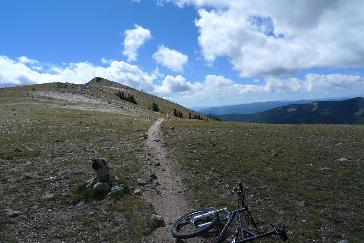
Monarch Crest Trail

More Crest goodness
The Monarch Crest portion of the CDT is one of my favorite trails. It cruises along the continental divide at 12,000ft, above timberline, for several miles. It is buttery smooth most of the time, but it would be a waste to blast through it with incredible views on both sides of the divide. I passed a large group of riders before reaching my turn-off at Agate Creek. Other than that, I almost had the ridge to myself. I rode a total of about 13 miles above 11,000ft.

Self portrait on the Crest
Agate Creek Trail was new for me. I knew it dropped steeply. The first two miles were non-stop death grip on the brakes. This trail is open to motos too, so it was pretty chopped up. It was very technical. A rider in the group I passed told me I was going to get wet feet on Agate Creek. Lower down, the trail crosses the creek many, many times. Each time, the stream got a little wider, a little deeper, and a lot more risky to try to ride across. Dismounts became frequent. I had forgotten my ankle brace on this ride. On the bike, I was more worried about going over the bars on this rocky trail than hurting an ankle. Off the bike, walking across rocky bottom streams was an ankle fracture waiting to happen. I was very tentative on this descent. It took me a long time to reach the bottom. Once the end is reach, a wicked steep set of switchbacks is taken back up to Hwy 50. I had to walk bits of this. The trail popped out about two miles from my car, which was a nice coast back down. My altitude headache never became a problem during the ride and was gone by the time I finished.

Top of Agate Creek Trail
I really liked this new, almost all dirt option to ride the crest. The descent is pretty bony, and you do miss the Rainbow Trail on this side. But it sure beats riding for better part of two hours up Hwy 50. The ride went 36.4 miles with 4600ft of climbing in 4.7 hours riding time. I was completely cooked when I got back to the car. I couldn't get to Sonic quick enough for a large malted milk shake.
Wednesday was one of my best trail riding days ever. The weather has been nothing but perfect here, 70's, no humidity, breezy, and brilliantly sunny. Wouldn't it be a shame if Hurricane Earl forced me to stay here an extra day or two? I had to do two rides on Wednesday. Never let a perfect day go to waste. This will have to wait for another post.
3 comments:
What bike were you on?
I brought my Titus Racer-X 26" dualie out here. Very glad I did. I've been hitting a lot of rough stuff. I would not be able to ride this stuff 4-6hrs per day on a hardtail.
Holy Smokes! I haven't checked your blog in a few days. All I can say is AWESOME! You're my hero Dougie......keep after it.
JB
Post a Comment