First falls on Falling Waters with Cathy and Aaron
Wet leaves on slimy granite were a constant battle heading up
Third falls on Falling Waters
Approaching summit of Little Haystack. We were bumming that
the ridgeline was socked in with clouds. The Franconia Ridge
is supposed to be one of the most spectacular ridges to hike in
New England.
Approaching The Gargoyles (I think) on the ridge
A balancing rock on the ridge
Moist air would approach the ridge at 50mph, rise and condense
in a flash. Moments of clarity like this were fleeting instances, but
it gave us hope we might see more.
Heading north along the ridge with a bit of sun even poking though
Working our way towards Lafayette. Skies were clearing.
Lafayette in background finally in the clear
Aaron and Cathy on final approach to Lafayette summit with
Mt Lincoln in background. Midweek, we nearly had the ridge
to ourselves.
The wind was so strong at the summit of Lafayette that it was
risky to stand in it. Plus it was quite cold. Cathy and Aaron
taking shelter with Mt Washington visible in upper left.
Initial descent off Lafayette
Mt Lafayette and Eagle Lake from the Greenleaf Hut
More hands and feet on the descent. I-93 in upper right, looking
south. The Old Bridle Path Trail we took down follows the
ridge that obstructs view of I-93. There were numerous vistas of the
Franconia Ridge to the east along the way.
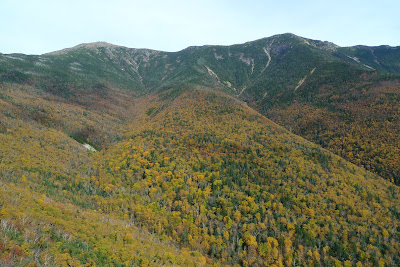
Peak color in Franconia Notch with Mt Truman and Mt Lincoln
New feature of GE shows profile and speed. Hike took 7.3hrs
with probably less than 5.5hrs moving time to cover the 9 miles.
We hiked loop in CCW direction.


No comments:
Post a Comment