The weather didn’t fully cooperate for the second week of
my trip when Cathy and mom joined me. Had to shuffle activities around weather
and Zion river levels. I had planned to
do a couple local Cedar City rides on Friday before heading back to SLC later
in the day. But I hadn’t hit Brian Head yet, the highest elevation ride I had
planned. The weather was going to be flawless, so I had to get this ride in
even if it made the day a bit rushed.
Brian Head is only 50 minutes away. I saw 37F on car
thermometer driving over. Also saw a cyclist in shorts coming over the pass.
That would have to be one chilly descent! On UT-143, I encountered mule deer
and cattle in the road many times, none too eager to get out of the way.
Sometimes the deer and cattle were together. I would begin my ride by climbing
a couple thousand feet back up this road and have to ride through all these
animals again.
I resisted the urge to put long layers on. The temp was in
the 40’s, but the ride goes right into a 3000ft climb. Will only freeze for a
few minutes until the blood gets flowing. Two weeks of continuous activity put
me in a pretty ragged state. Despite being on a “schedule,” I wasn’t pushing
any harder than a light tempo pace up this climb. At least I could go minutes
at a time without a car passing.
The top of UT-143 touches into Cedar Breaks National
Monument. There was a pull-off right there, so I checked it out. I never made
it into Bryce. Cedar Breaks must be a taste of what Bryce is like.
Up on the plateau, Brian Head prominently jutted out. Almost
a thousand feet to go on a gravel access road. Fall colors were starting to
show, and leaf peepers were out. A few cars headed to the summit. As I
approached the summit, a group of a dozen or so mountain bikers were just
beginning to head down, obviously having been shuttled up there. There were only two
women up there while I hung out at the summit for a while. Might have been 50F
but zero wind and so quiet. Visibility was easily over 100 miles.
Beginning the descent, a brief chunky hike-a-bike was encountered. I
thought oh no, is that a taste of more to come? No, the descent had something
else in store. The large pack of riders appeared to have turned on Dark Hollow
descent, which was fine by me. I ended up having the remaining 95% of the
descent to myself.
Riding along the Sidney Peaks ridgeline trail at 11,000ft,
the views were comparable to Salida or Crested Butte ridgeline riding. Just
spectacular on this crisp brilliant day.
Splitting off onto the Left Fork Bunker Creek Trail, things
got interesting. This cut into forested patches. The area experienced extreme
wind for a couple days earlier in the
week when all the torential rain fell. I encountered a couple downed trees and
hoped that was it. Then I encountered a tangled mess so thick, you couldn’t
even poke an arm into it. I could not find a way through the forest around it.
I tried multiple lines, each time getting my bike so stuck I thought I’d have
to abandon it in place. I was not too happy. I had just crossed a double track
and though about back tracking and taking the road back down. I did get around
the mess, only to find tree after tree down. Half of the trees were live trees,
not just beetle dead trees.
Once I got a little further down off the ridge, the flow
improved. Lots of derailleur destroying debris to watch out for, but some
ruckus speed could be carried. Left Fork pops out on Bunker Creek jeep road,
which I was parked at the bottom of. No more trees to dismount for! There was
still a surprising amount of water on the doubletrack, fortunately all of it
avoidable.
I finished the nearly 30mi ride in 2.9hrs, much less time
than I would have thought with all the bush-whacking up top. Now it was time
for the gloomy process of packing up the bike and heading back to the “real”
world. Or was I in the real world for the last two weeks? I could easily become
a MTB bum.


Zion National Park from UT-14 on drive to Brian Head.
Think that is West Temple poking up in far distance.

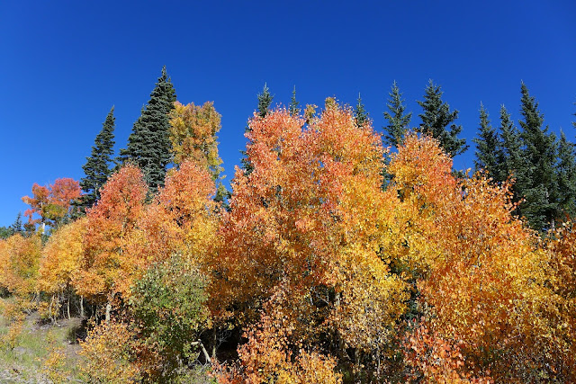
Color while riding up UT-143 approaching 10,000ft


Cedar Breaks National Monument. Less than ideal lighting, but pretty cool.
On right in distance is blowhard mountain, where Luke and I bombed down
as thunder was starting.


Brian Head from plateau on UT-143

From summit of Brian Head looking north. Several hundred feet vertical drop
to ski area below.

View from Brian Head looking over Cedar Breaks.


Brian Head Ski area. Lift service does not go to summit

Summit shelter

Sidney Peaks Trail along 11,000ft ridgeline


Riding on Sidney Peaks trail was comparable to Crested Butte or Salida


Love alpine riding


View north along Sidney Peaks Trail

The blow-down section on Left Fork Trail. Forest was so dense here with so many trees down
that it was almost impossible to bush whack around this mess

Frequent dismounts for a while on Left Fork Trail

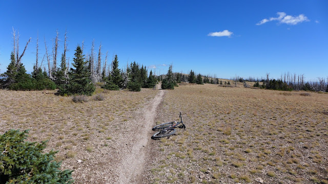
Nearing the bottom on Bunker Creek jeep road
1 comment:
What an epic vacation! And killer photos. Thanks for sharing.
Post a Comment