The first full day I joined Luke Stone to ride the ridgeline that towers above Ogden, Utah, point-to-point . A number of trails are linked, including Grizzly Peak, White Rock, Willard Mtn Rd and Skyline. The route gains a vertical mile from town and entails upwards of 7000ft total climbing in just 35mi.
The oppressive heat that plagued the area earlier broke. The morning was crisp, almost necessitating long layers. Not a cloud in sight either, nor any smoke from wild fires further north. Was setting up to be a photo-perfect day.
Starting out on Grizzly was a shock to the system. No warm-up, just straight into double-digit grades on very narrow bench-cut singletrack with moderate exposure. I was pushing anaerobic efforts more often than not just to go fast enough to not fall over the edge. Ugh. How was this going to set me up on the 3rd, 5th or 10th day of my trip? Luke was schooling me on the climb, and he has 60 pounds on me!
Luke had ridden this ridge a couple weeks earlier and had a route tweak in mind to soften a particularly heinous climbing section by swinging out to White Rock and then back to the Grizzly Trail. Good call. Early morning light was fabulous. In no time, features in the valley were looking tiny.
The switchbacks were unrelenting. Luke was doing far better than I, probably at almost 2:1 ratio at cleaning them. I just once wanted to clean a switchback he botched. It happened. Just once.
White Rock Trail seemed barely used and a bit overgrown in spots. I love "barely there" kind of trails. Got plastered with burrs though.
Once gaining the ridgeline, the grade tempered a bit. We reached Grizzly Peak, and at first Luke poo-pooed taking the spur to the actual peak. It look like it was just a wee bump, but no, it was a couple minutes of anaerobic chunder mashing. Worth it though, 360 degree view.
On the ridge, we picked up a wider trail that brought us into Willard Basin. A 4WD/ATV road leads up there. There was fair amount of holiday weekend traffic. I was amazed to see how courteous the motorized users were of cyclists.
A lot of hunters up there too. Not sure what season it is. Lot of guns in Utah. Eating breakfast at the hotel, a guy walks by with revolver shoved into the top of his jeans. Utah is an open carry state. Doesn't freak me out. I grew up in family of avid sportsmen. I think I had my first gun before I even had a car. Times sure have changed.
Luke learned that water is available in Willard Basin from a spring. We were banking on it, as this is a very long traverse with no other water sources available. Supposedly it was potable. I did not bring the filter I just bought. At the spring, it is just a pipe poking out of ground with water flowing out of it. No signs. Ice cold. It was crystal clear with no sediment. Looked good to me! We filled our Camelbaks.
We followed the dirt 4WD road up to Inspiration Point, which is near Willard Peak and gives awesome bird's eye view of Ogden and the SLC basin. A lot of people come up here, but vast majority use motorized means.
Dropping from this peak to skirt around Willard Peak was uber sketchy. Hike-a-bike down with fear of death slipping. Well, maybe not death, but certainly getting sliced wide open on the jagged rocks.
On Skyline Trail now, we scared up a mountain goat. I was just asking Luke earlier in the ride if he'd seen any goats on his rides yep. Nope. We'll he saw one now. Skyline Trail follows the crest all the way down to North Ogden Canyon Rd, but not before going over Ben Lomond, the highest point of our ride at nearly 10,000ft.
The scenery became surreal, on par with scenery from the best places I have ever ridden in Colorado and elsewhere. The risk factor was commensurate with the views. Lots of exposure. There were a couple brief hike-a-bikes leading up to Ben Lomond, maybe partly just because I was weirded out by the exposure. The final 30ft to the peak was a rock scramble without the bikes. Just like Inspiration Point, killer view from Ben Lomond.
Luke told me how he crashed around switchbacks the first time he came down from Ben Lomond. Great. If he was crashing, I'll be walking. The first 500+ feet of drop was pretty much all loose scree with impossible (for me) to negotiate switchbacks. Once we got through this section, the runs between switchbacks became tests of nerves. How fast do you dare go? Even if I could have hung with Luke, I had to back off because he kicked up huge plume of dust. My eyes and back of my throat were getting caked.
Many hikers were encountered on the descent. We chatted briefly with one group. A guy asked how far were going. After explaining that we're riding the whole ridge point to point, he quipped "that sounds like an Ogden Enchilada." This was a reference to a ride in Moab, UT that is called The Whole Enchilada. He was obviously familiar with it.
Luke had popped a spoke in his custom carbon wheels earlier in the ride, and I kept thinking the way he was bombing this descent, nothing good was going to come from it. But the wheel barely lost any trueness with the missing spoke. Says a lot for carbon MTB wheels. I've always been a skeptic, but less so now.
Once we popped out at Canyon Rd, we crossed over to continue the descent on Pioneer Trail, a segment Luke did not include in his last ride. A bit more of the same, and I was surprised how much vertical was still needed to be lost getting back down to town.
Just before popping out onto pavement, we hit a new trail that was all bermed turns and kickers. It was a blast, nice touch to finish a ride. It meandered through an area full of big yellow daisies, and bees were swarming the area. Without warning, I felt like I just took a staple to my left nipple. A bee got caught in behind my Camelbak sternum strap and bit me. Son of a bitch! I hadn't been bit by a bee since a few years ago at NEK. That time, my hand swelled up to 2x normal size. Now my left nipple was on fire and swelling up. I was going to be lop-sided for a while!
Once on pavement, it was a quick, mostly downhill 4mi cruise back to the car at my hotel. I logged about 36mi with 6800ft of climbing in 4:45hrs moving time. This ride ranks right up there with the Monarch Crest in Salida, CO or Trail 401 in Crested Butte, CO. It is a much less refined ride than these other two. The climbing is more punishing, there are brief hike-a-bikes, and you have masses of civilization below you, but the terrain you are interacting with is very special. So much diversity. Ogden is a place I'd consider moving to in retirement. How many more years would I physically be able to pull off rides like this?
Here are select photos from ride. I posted several more photos in FB album.

Starting out on Grizzly Trail.

Seems these burrs would just jump out and stick on ya. On White Rock Trail.

Luke rounding switch back on White Rock Trail with the white rock in background.

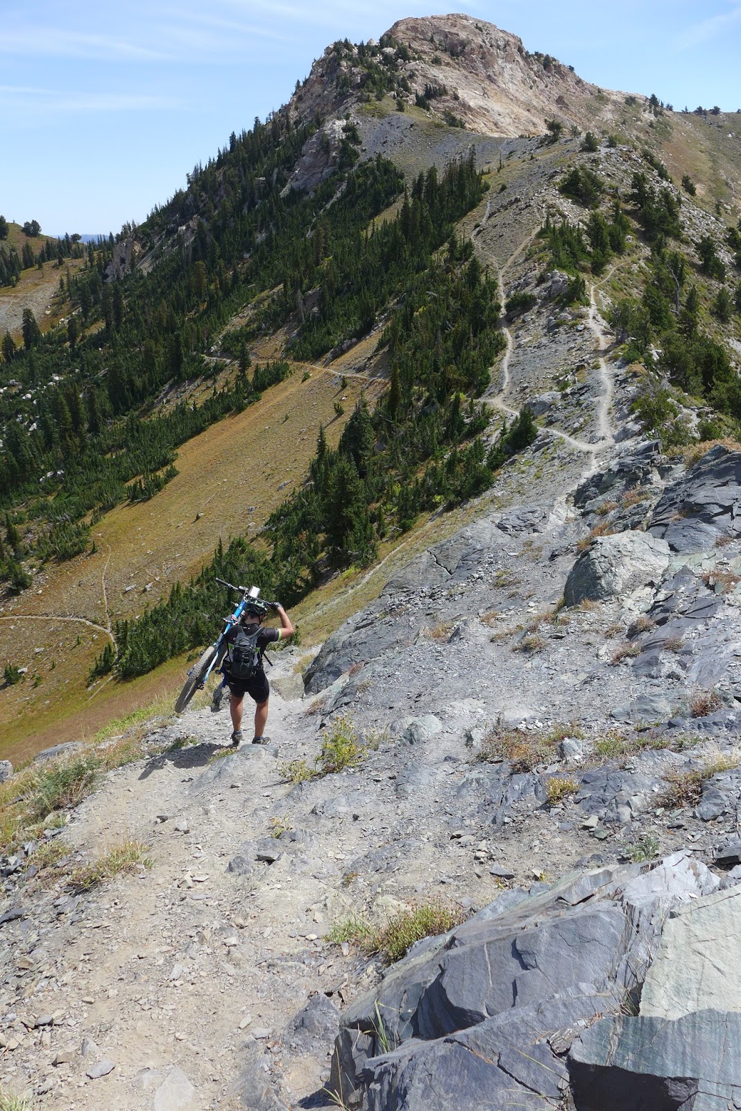
Probably back on Grizzly Trail with Bringham City way below.

Willard Basin spring.

Willard Peak from Inspiration Point with Skyline Trail connecting two.

The SLC basin from Inspiration Point.
Initial hike-a-bike down from Inspiration Point on Skyline Trail

Skyline Trail. Doesn't get any better than this.

Fun terrain to interact with on Skyline.

Goat from Skyline Trail

Many nice vistas from Skyline Trail. Scary drop from this one.

Could be Monarch Crest or Trail 401 if the city below didn't give it away.
Just love riding stuff like this.

Luke's silhouette on Skyline Trail

Skyline Trail looking north back at Willard Peak.

Luke traversing a "no-fall zone" on Skyline Trail approaching Ben Lomond

Looking north along Skyline Trail back to Willard Peak from Ben Lomond

One of many sketchy switchbacks on initial plummet from Ben Lomond summit.
No comments:
Post a Comment