There are several sections of Colorado Trail (CT) that fellow cyclists rave about. One section is from Silverton to Lake City, which follows the Continental Divide at 10,000-13,000ft above sea level. I can't ride this whole section alone without bike packing (spending the night on the trail) or with a massive shuttle to start an all day ride. So I must carefully carve out a section I can "self shuttle."
Self shuttling means earning my turns and making a complete loop out of the ride. There are very few access points to this section of the CT. One near Cataract Lake is closed to bikes. I'd love to ride that section too, but it wasn't going to work on this trip. Another route up is Wager Gulch Rd, a jeep road open to the public. It climbs from roughly 9300ft to 12,300ft. I had no intel on suitability for climbing by bicycle. It could have been all hike-a-bike for all I knew. I did know average grade was about 12%. This meant I had a good chunk of a Mt Washington climb with 30 pound bike, on rough surface carrying 15# pack, in very thin air just to start the ridge riding.
I also chose a speculative way down from the ridge, one map calling the route 56. Was that a Forest Service road number? County road? No idea. All I knew was the riding up top was supposed to be special. Most that have ridden it get on near Silverton via Stony Pass and get off on Hwy 149. I could have ridden through to Hwy 149, but then I'd add many paved miles on shoulderless state highway to get back to my car. What fun would there be in that? I'd rather risk a massive Hill Junkie style boondoggle.
It was frigid driving over to Lake City. I saw dusting of snow on the highest peaks. Yikes! Would I be riding in snow? I started out with near winter clothing on this time, as there is a nearly flat 9 mile lead-in before the real climbing started. The Garmin recorded a low of 36F for the ride.
I get to Wager Gulch Rd (aka County Route 36) and see right way it was not going to be a picnic. The first two miles were unbelievably difficult. The grade rarely dropped below 15%, and there were extended sections of 18-20%. Fortunately, the surface was well packed. Maybe the recent rains helped. That just meant there were no excuses. You just had to pedal, dammit! Two 4WD's and one moto passed me on the way up. One in a ordinary SUV stopped at a fork later and asked me for directions to Carson, an old mining ghost town that has been preserved. I said I was going by that way, so it had to be the fork to the right.
I was dismayed every time the grade dropped less than 12%. That just meant the grade had to exceed 12% to make up for it. I cleaned the whole climb, but dang that took a lot out of me.
I reached the divide in less time than I budgeted. But the sky told me that finally, today, I would not have to worry about bad weather popping up. I could take my time on the crest. This was good, as the visibility must have been over 100 miles.
From the Carson pass at 12,300ft, CT/CDT singletrack is picked up. Sweet! It switch-backed to near the summit of Coney Peak at 13,300ft. The view in all directions was unbelievable. This was clearly the most "in the mountains" sensation I've experienced.
There were three small climbs and one major climb along the divide. I passed a total of five backpackers along the way, a group of three and two singles. Not only did I see no bikes, there were no bike tracks. There were brief hike-a-bikes along the way, a couple places where the trail traversed talus fields. Small price to pay to be up here with your bike. There was a moderate breeze. The temp hovered around 50F, a little too cool for short sleeves, but I resisted the urge to put long layers back on.
I was sad when it was time to head back down. The descent was extremely sketchy at times, very loose and rutted. All rideable, but great care with death grip on brakes was needed. I'd never be able to ride up the way I went down.
I finished the 35mi loop with 5800ft of climbing in 4.5hrs moving time. Almost an hour of stopped time was logged shooting photos. I took 85 photos on this ride. Enough words. Here are a few cherry-picked photos from the ride.

Lake San Cristobal reflecting the continental divide at start of ride.

Carson ghost town from Wager Gulch Rd. Vehicle parked there is from guy who asked for directions.

From the divide looking across valley I started in.

On the CT at 13,200ft looking south.
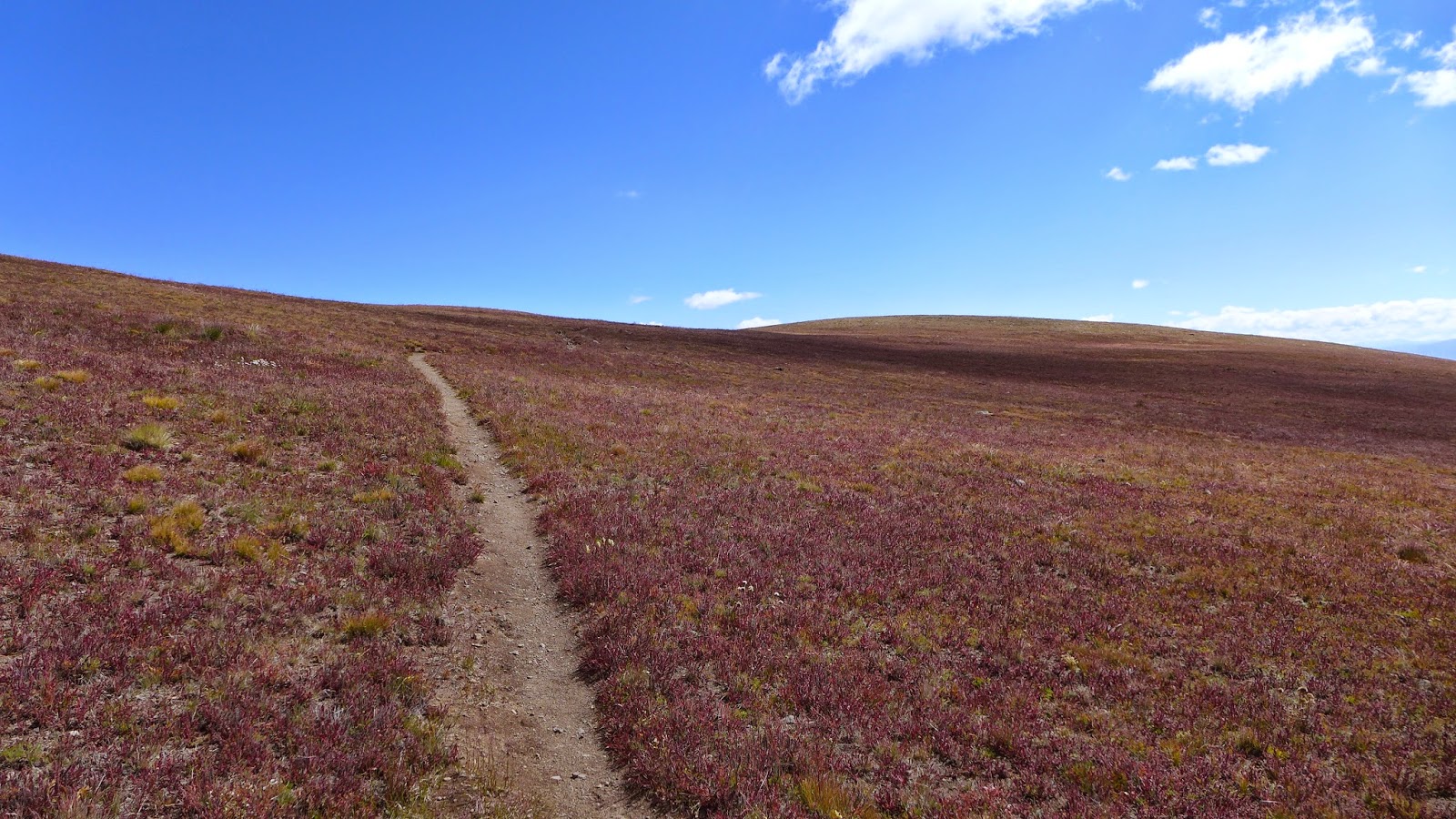
Sometimes this is all you see. Around 13,000ft elevation. I love it!

Looking north along the divide.

Red Mountain.

Heading north along the divide.

Wager Gulch Rd, my route up, faintly visible.

Looking back south.

Lake San Cristobal where I started and Red Mountain on left.

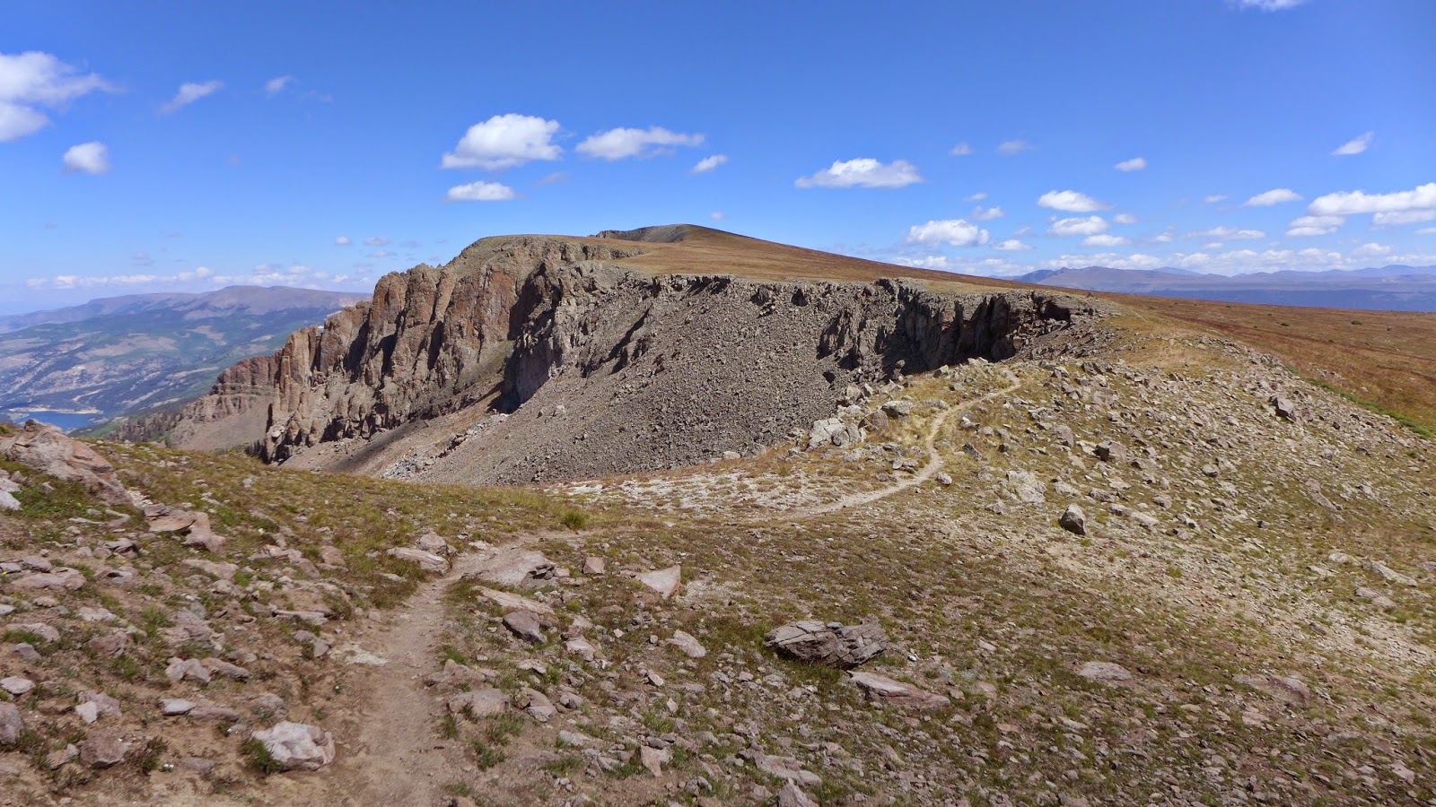
Another perspective catching singletrack below after traversing some very steep talus switchbacks.

Looking north along the divide, about to descend some very steep swichbacks in talus (brief hike-a-bike).

I had just come down from up there on some pretty sketchy switchbacks in that talus field.
Heading north along the rim.


Beginning descent. Red Mountain in foreground and Uncompahgre Peak in background. Like to hike that one some day.

Uber steep and often sketchy County Road 56.
Touch of color in the aspens.

From Hwy 149 switchback looking at the divide, pretty much the stretch I did on one frame.
Shooting into the sun washes image out a bit.
1 comment:
Just an amazing ride! I'm jealous!
Post a Comment